Idyllwild Topo Map California
To zoom in, hover over the map of Idyllwild
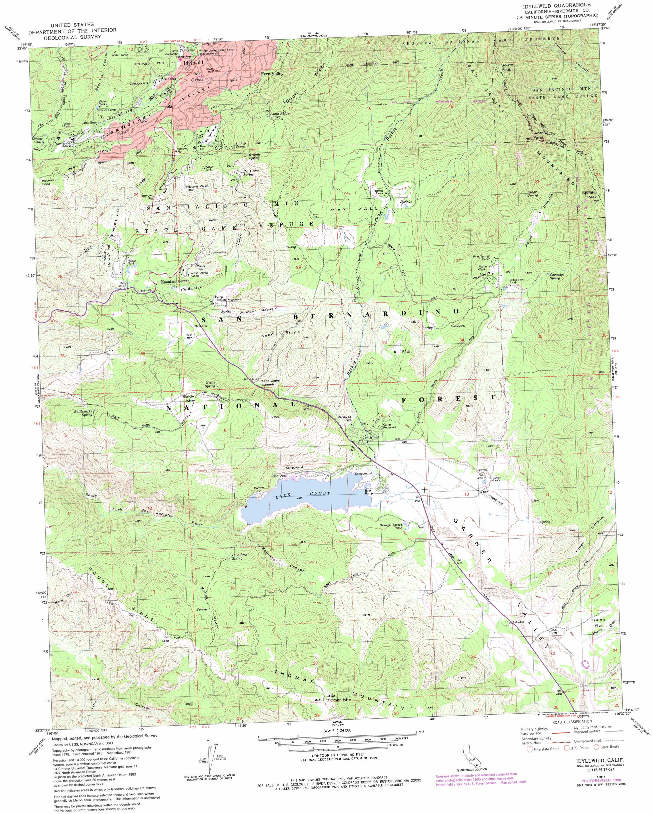
USGS Topo Quad 33116f6 - 1:24,000 scale
| Topo Map Name: | Idyllwild |
| USGS Topo Quad ID: | 33116f6 |
| Print Size: | ca. 21 1/4" wide x 27" high |
| Southeast Coordinates: | 33.625° N latitude / 116.625° W longitude |
| Map Center Coordinates: | 33.6875° N latitude / 116.6875° W longitude |
| U.S. State: | CA |
| Filename: | o33116f6.jpg |
| Download Map JPG Image: | Idyllwild topo map 1:24,000 scale |
| Map Type: | Topographic |
| Topo Series: | 7.5´ |
| Map Scale: | 1:24,000 |
| Source of Map Images: | United States Geological Survey (USGS) |
| Alternate Map Versions: |
Idyllwild CA 1981, updated 1982 Download PDF Buy paper map Idyllwild CA 1981, updated 1988 Download PDF Buy paper map Idyllwild CA 1996, updated 1999 Download PDF Buy paper map Idyllwild CA 2012 Download PDF Buy paper map Idyllwild CA 2015 Download PDF Buy paper map |
| FStopo: | US Forest Service topo Idyllwild is available: Download FStopo PDF Download FStopo TIF |
1:24,000 Topo Quads surrounding Idyllwild
Beaumont |
Cabazon |
White Water |
Desert Hot Springs |
Seven Palms Valley |
San Jacinto |
Lake Fulmor |
San Jacinto Peak |
Palm Springs |
Cathedral City |
Hemet |
Blackburn Canyon |
Idyllwild |
Palm View Peak |
Rancho Mirage |
Sage |
Cahuilla Mountain |
Anza |
Butterfly Peak |
Toro Peak |
Vail Lake |
Aguanga |
Beauty Mountain |
Bucksnort Mountain |
Collins Valley |
> Back to 33116e1 at 1:100,000 scale
> Back to 33116a1 at 1:250,000 scale
> Back to U.S. Topo Maps home
Idyllwild topo map: Gazetteer
Idyllwild: Basins
May Valley elevation 1548m 5078′Idyllwild: Dams
Lake Hemet 817 Dam elevation 1323m 4340′Idyllwild: Flats
Blodgett Flat elevation 1484m 4868′Johnston Meadow elevation 1438m 4717′
K Flat elevation 1445m 4740′
Quinn Flat elevation 1376m 4514′
Redshank elevation 1533m 5029′
Saunders Meadow elevation 1692m 5551′
Idyllwild: Gaps
Keen Camp Summit elevation 1507m 4944′Idyllwild: Parks
Hurkey Creek Park elevation 1355m 4445′Idyllwild Park elevation 1614m 5295′
McCall Memorial Park elevation 1352m 4435′
Idyllwild: Populated Places
Idyllwild elevation 1601m 5252′Mountain Center elevation 1377m 4517′
Idyllwild: Post Offices
Idyllwild Post Office elevation 1626m 5334′Idyllwild Post Office (historical) elevation 1601m 5252′
Keen Camp Post Office (historical) elevation 1413m 4635′
Idyllwild: Reservoirs
Lake Hemet elevation 1323m 4340′Idyllwild: Ridges
Chalk Hill elevation 1600m 5249′Keen Ridge elevation 1584m 5196′
Rouse Ridge elevation 1609m 5278′
South Ridge elevation 2268m 7440′
West Ridge elevation 1627m 5337′
Idyllwild: Springs
Big Cedar Spring elevation 1778m 5833′Cartridge Spring elevation 1643m 5390′
Cedar Spring elevation 1841m 6040′
Granite Spring elevation 1872m 6141′
Jozee Spring elevation 1537m 5042′
Nettle Spring elevation 1619m 5311′
Pine Tree Spring elevation 1402m 4599′
Rattlesnake Spring elevation 1572m 5157′
South Ridge Spring elevation 1939m 6361′
Idyllwild: Streams
Coldwater Creek elevation 1120m 3674′Herkey Creek elevation 1324m 4343′
Lilly Creek elevation 1575m 5167′
Morris Creek elevation 1366m 4481′
Idyllwild: Summits
Antsell Rock elevation 2333m 7654′Apache Peak elevation 2302m 7552′
Baldy Mountain elevation 1697m 5567′
Inspiration Point elevation 1637m 5370′
Little Thomas Mountain elevation 2002m 6568′
South Peak elevation 2393m 7851′
Idyllwild: Valleys
Apple Canyon elevation 1540m 5052′Bear Trap Canyon elevation 1550m 5085′
Fobes Canyon elevation 1354m 4442′
Hemet Valley elevation 1323m 4340′
Spillway Canyon elevation 1271m 4169′
Willow Valley elevation 1224m 4015′
Idyllwild digital topo map on disk
Buy this Idyllwild topo map showing relief, roads, GPS coordinates and other geographical features, as a high-resolution digital map file on DVD: