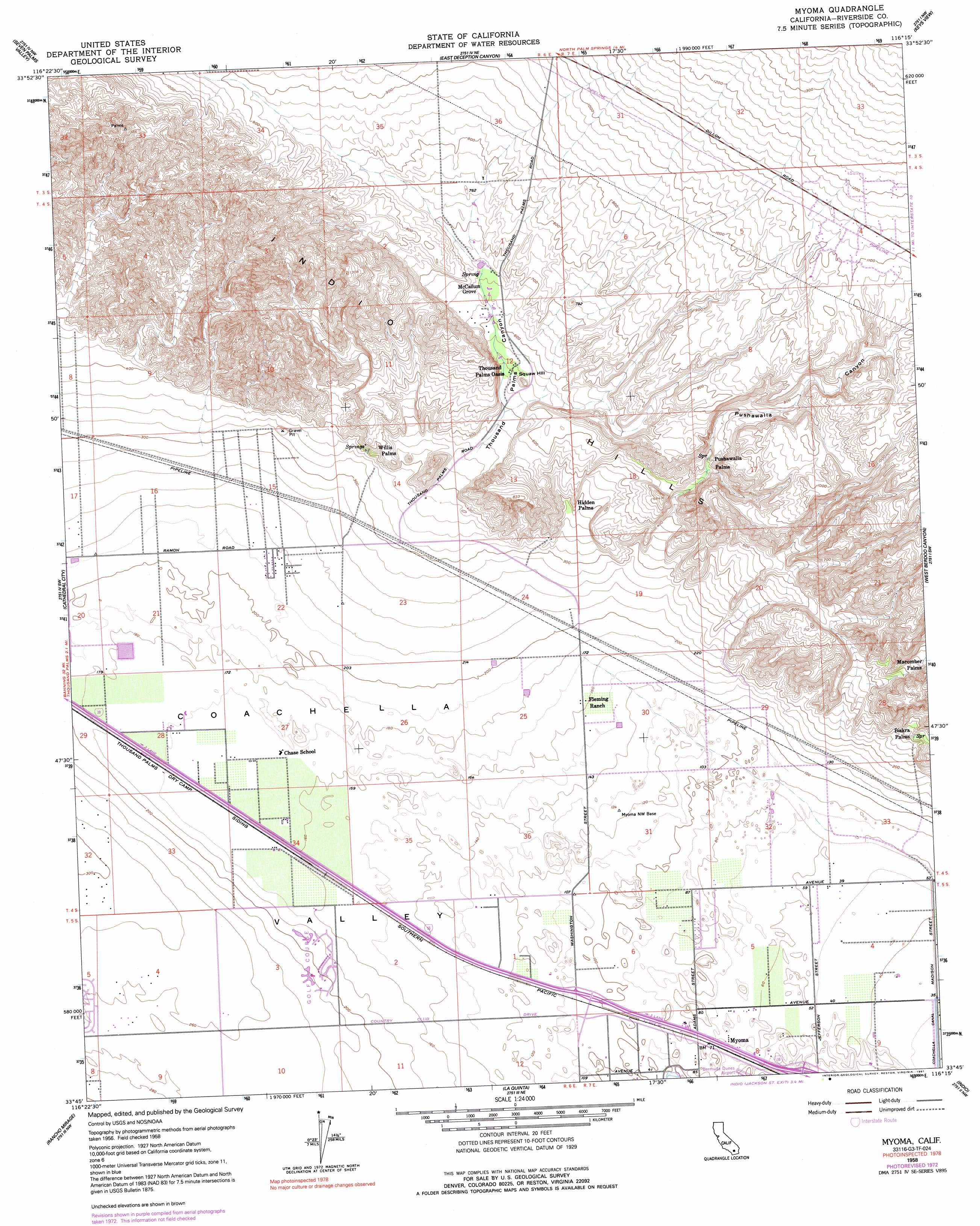
Myoma Topo Map California
To zoom in, hover over the map of Myoma
USGS Topo Quad 33116g3 - 1:24,000 scale
| Topo Map Name: | Myoma |
| USGS Topo Quad ID: | 33116g3 |
| Print Size: | ca. 21 1/4" wide x 27" high |
| Southeast Coordinates: | 33.75° N latitude / 116.25° W longitude |
| Map Center Coordinates: | 33.8125° N latitude / 116.3125° W longitude |
| U.S. State: | CA |
| Filename: | o33116g3.jpg |
| Download Map JPG Image: | Myoma topo map 1:24,000 scale |
| Map Type: | Topographic |
| Topo Series: | 7.5´ |
| Map Scale: | 1:24,000 |
| Source of Map Images: | United States Geological Survey (USGS) |
| Alternate Map Versions: |
Myoma CA 1958, updated 1959 Download PDF Buy paper map Myoma CA 1958, updated 1967 Download PDF Buy paper map Myoma CA 1958, updated 1973 Download PDF Buy paper map Myoma CA 1958, updated 1991 Download PDF Buy paper map Myoma CA 2012 Download PDF Buy paper map Myoma CA 2015 Download PDF Buy paper map |
1:24,000 Topo Quads surrounding Myoma
Morongo Valley |
Yucca Valley South |
Joshua Tree South |
Indian Cove |
Queen Mountain |
Desert Hot Springs |
Seven Palms Valley |
East Deception Canyon |
Keys View |
Malapai Hill |
Palm Springs |
Cathedral City |
Myoma |
West Berdoo Canyon |
Rockhouse Canyon |
Palm View Peak |
Rancho Mirage |
La Quinta |
Indio |
Thermal Canyon |
Butterfly Peak |
Toro Peak |
Martinez Mountain |
Valerie |
Mecca |
> Back to 33116e1 at 1:100,000 scale
> Back to 33116a1 at 1:250,000 scale
> Back to U.S. Topo Maps home
Myoma topo map: Gazetteer
Myoma: Parks
Coachella Valley Fringe-Toed Lizard Preserve elevation 60m 196′Indian Hills Palms Park elevation 160m 524′
Myoma: Populated Places
Biskra Palms elevation 95m 311′Hidden Palms elevation 131m 429′
Macomber Palms elevation 161m 528′
Myoma elevation 22m 72′
Pushawalla Palms elevation 174m 570′
Shadow Ridge Creek elevation 59m 193′
Willis Palms elevation 124m 406′
Myoma: Ranges
Indio Hills elevation 234m 767′Myoma: Summits
Squaw Hill elevation 174m 570′Myoma: Trails
Hidden Horseshoe and Pushawalla Palms Trail elevation 177m 580′Indian Palms Trail elevation 179m 587′
McCallum Trail elevation 188m 616′
Smoke Tree Ranch Trail elevation 158m 518′
Wash Trail elevation 225m 738′
Willis Palms and West Mesa Trail elevation 192m 629′
Myoma: Valleys
Coachella Valley elevation 85m 278′Fun Valley elevation 256m 839′
Pushawalla Canyon elevation 95m 311′
Thousand Palms Canyon elevation 114m 374′
Myoma: Woods
McCallum Grove elevation 195m 639′Myoma digital topo map on disk
Buy this Myoma topo map showing relief, roads, GPS coordinates and other geographical features, as a high-resolution digital map file on DVD: