San Jacinto Topo Map California
To zoom in, hover over the map of San Jacinto
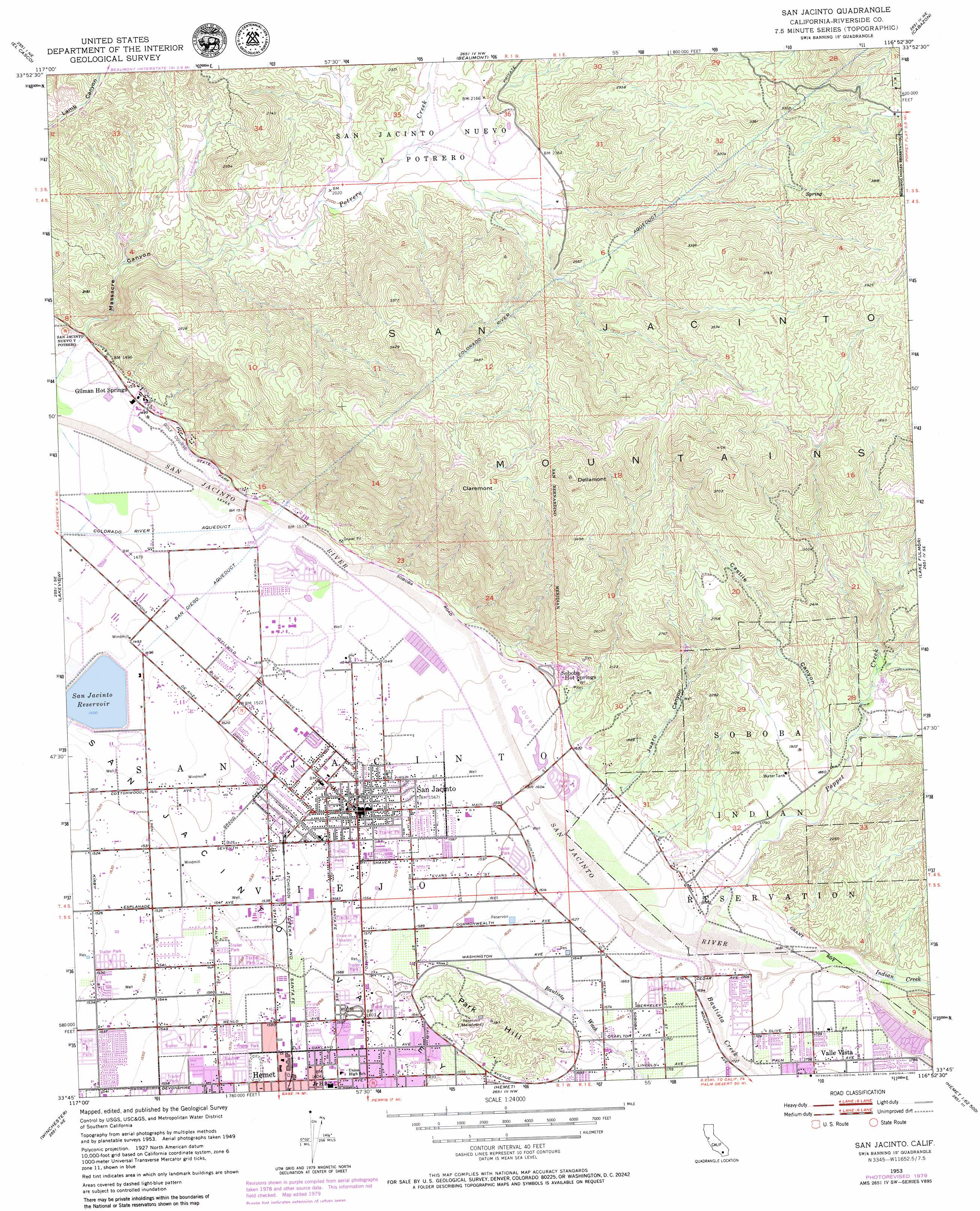
USGS Topo Quad 33116g8 - 1:24,000 scale
| Topo Map Name: | San Jacinto |
| USGS Topo Quad ID: | 33116g8 |
| Print Size: | ca. 21 1/4" wide x 27" high |
| Southeast Coordinates: | 33.75° N latitude / 116.875° W longitude |
| Map Center Coordinates: | 33.8125° N latitude / 116.9375° W longitude |
| U.S. State: | CA |
| Filename: | o33116g8.jpg |
| Download Map JPG Image: | San Jacinto topo map 1:24,000 scale |
| Map Type: | Topographic |
| Topo Series: | 7.5´ |
| Map Scale: | 1:24,000 |
| Source of Map Images: | United States Geological Survey (USGS) |
| Alternate Map Versions: |
San Jacinto CA 1953, updated 1954 Download PDF Buy paper map San Jacinto CA 1953, updated 1959 Download PDF Buy paper map San Jacinto CA 1953, updated 1973 Download PDF Buy paper map San Jacinto CA 1953, updated 1980 Download PDF Buy paper map San Jacinto CA 1996, updated 1999 Download PDF Buy paper map San Jacinto CA 2012 Download PDF Buy paper map San Jacinto CA 2015 Download PDF Buy paper map |
| FStopo: | US Forest Service topo San Jacinto is available: Download FStopo PDF Download FStopo TIF |
1:24,000 Topo Quads surrounding San Jacinto
Redlands |
Yucaipa |
Forest Falls |
San Gorgonio Mountain |
Catclaw Flat |
Sunnymead |
El Casco |
Beaumont |
Cabazon |
White Water |
Perris |
Lakeview |
San Jacinto |
Lake Fulmor |
San Jacinto Peak |
Romoland |
Winchester |
Hemet |
Blackburn Canyon |
Idyllwild |
Murrieta |
Bachelor Mountain |
Sage |
Cahuilla Mountain |
Anza |
> Back to 33116e1 at 1:100,000 scale
> Back to 33116a1 at 1:250,000 scale
> Back to U.S. Topo Maps home
San Jacinto topo map: Gazetteer
San Jacinto: Airports
Hemet Valley Hospital Helistop elevation 493m 1617′San Jacinto: Areas
North Mountain Experimental Area elevation 979m 3211′San Jacinto: Dams
San Jacinto Dam elevation 457m 1499′San Jacinto: Parks
Hoffman Park elevation 476m 1561′Mistletoe Park elevation 481m 1578′
Rancho Park elevation 485m 1591′
Salee Park elevation 474m 1555′
San Jacinto River Park elevation 459m 1505′
Valley Wide Regional Park elevation 467m 1532′
San Jacinto: Populated Places
Gilman Hot Springs elevation 451m 1479′San Jacinto elevation 477m 1564′
Soboba Hot Springs elevation 500m 1640′
San Jacinto: Post Offices
San Jacinto Post Office elevation 478m 1568′San Jacinto: Reservoirs
San Jacinto Reservoir elevation 457m 1499′San Jacinto: Streams
Bautista Creek elevation 508m 1666′Bautista Wash elevation 493m 1617′
Indian Creek elevation 518m 1699′
Poppet Creek elevation 508m 1666′
San Jacinto: Summits
Claremont elevation 1181m 3874′Dellamont elevation 1231m 4038′
Park Hill elevation 577m 1893′
San Jacinto: Valleys
Castile Canyon elevation 549m 1801′Juaro Canyon elevation 510m 1673′
Massacre Canyon elevation 470m 1541′
San Jacinto digital topo map on disk
Buy this San Jacinto topo map showing relief, roads, GPS coordinates and other geographical features, as a high-resolution digital map file on DVD: