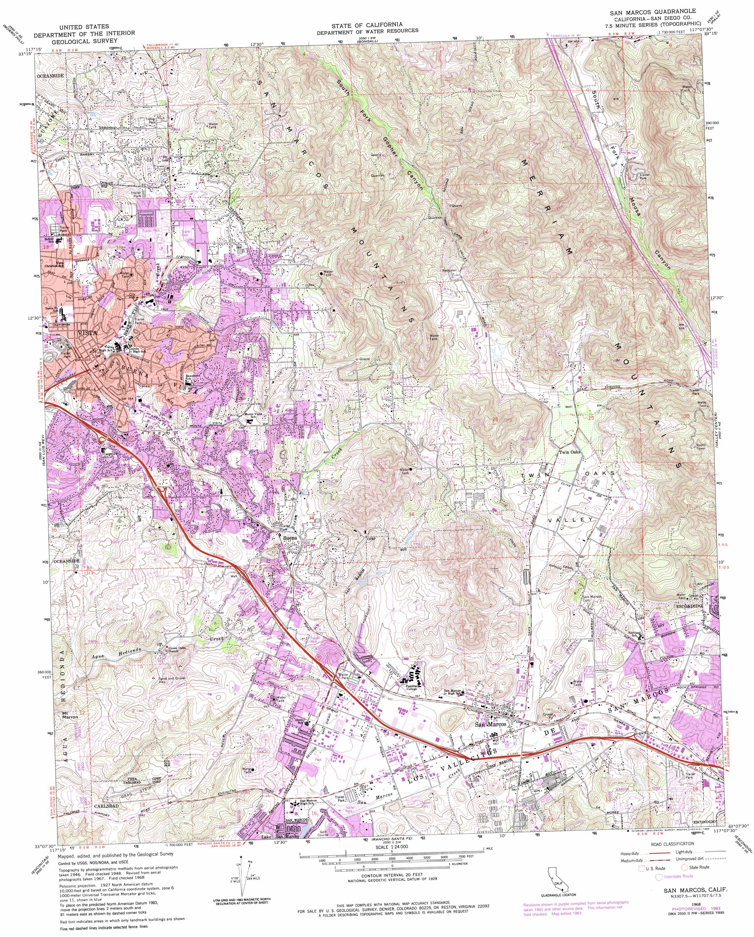
San Marcos Topo Map California
To zoom in, hover over the map of San Marcos
USGS Topo Quad 33117b2 - 1:24,000 scale
| Topo Map Name: | San Marcos |
| USGS Topo Quad ID: | 33117b2 |
| Print Size: | ca. 21 1/4" wide x 27" high |
| Southeast Coordinates: | 33.125° N latitude / 117.125° W longitude |
| Map Center Coordinates: | 33.1875° N latitude / 117.1875° W longitude |
| U.S. State: | CA |
| Filename: | o33117b2.jpg |
| Download Map JPG Image: | San Marcos topo map 1:24,000 scale |
| Map Type: | Topographic |
| Topo Series: | 7.5´ |
| Map Scale: | 1:24,000 |
| Source of Map Images: | United States Geological Survey (USGS) |
| Alternate Map Versions: |
San Marcos CA 1948, updated 1955 Download PDF Buy paper map San Marcos CA 1948, updated 1965 Download PDF Buy paper map San Marcos CA 1949 Download PDF Buy paper map San Marcos CA 1968, updated 1970 Download PDF Buy paper map San Marcos CA 1968, updated 1979 Download PDF Buy paper map San Marcos CA 1968, updated 1983 Download PDF Buy paper map San Marcos CA 1996, updated 2000 Download PDF Buy paper map San Marcos CA 2012 Download PDF Buy paper map San Marcos CA 2015 Download PDF Buy paper map |
1:24,000 Topo Quads surrounding San Marcos
Margarita Peak |
Fallbrook |
Temecula |
Pechanga |
Vail Lake |
Las Pulgas Canyon |
Morro Hill |
Bonsall |
Pala |
Boucher Hill |
Oceanside |
San Luis Rey |
San Marcos |
Valley Center |
Rodriguez Mountain |
Encinitas |
Rancho Santa Fe |
Escondido |
San Pasqual |
|
Del Mar |
Poway |
San Vicente Reservoir |
> Back to 33117a1 at 1:100,000 scale
> Back to 33116a1 at 1:250,000 scale
> Back to U.S. Topo Maps home
San Marcos topo map: Gazetteer
San Marcos: Crossings
Interchange 37 elevation 308m 1010′San Marcos: Parks
Brengle Terrace City Park elevation 142m 465′Buena Vista Park elevation 115m 377′
Cerro de las Posas Park elevation 207m 679′
Civic Center Park elevation 120m 393′
Helen Bougher Memorial Park elevation 219m 718′
Jacks Pond Park elevation 219m 718′
Lake Moree Park elevation 239m 784′
Raintree Park elevation 127m 416′
Thibodo Park elevation 151m 495′
Walnut Grove Park elevation 215m 705′
Wildwood Park elevation 111m 364′
William R Bradley Park elevation 165m 541′
Woodland Park elevation 208m 682′
San Marcos: Populated Places
Buena elevation 138m 452′Casitas del Sol Mobile Home Park elevation 211m 692′
Foothills of San Marcos Mobile Home Park elevation 240m 787′
Gold Star Mobile Home elevation 123m 403′
Lake San Marcos elevation 160m 524′
LaMoree Mobile Estates elevation 236m 774′
Lawrence Welk Resort Village elevation 173m 567′
Madrid Manor Mobile Home Park elevation 215m 705′
Palomar East Mobile Home Park elevation 176m 577′
Palomar West Mobile Home Park elevation 209m 685′
Rancho Vista Mobile Home Park elevation 148m 485′
Richland elevation 214m 702′
San Marcos elevation 177m 580′
San Marcos Mobile Estates elevation 222m 728′
Sierra Vista Trailer Park elevation 123m 403′
Sycamore Creek Mobile Home Park elevation 113m 370′
Twin Oaks elevation 220m 721′
Vista elevation 100m 328′
Vista Cascade Mobile Home Park elevation 140m 459′
Vista Manor Trailer Park elevation 120m 393′
San Marcos: Post Offices
San Marcos Post Office elevation 179m 587′Vista Post Office elevation 115m 377′
San Marcos: Ranges
Buena Vista Hills elevation 166m 544′Merriam Mountains elevation 423m 1387′
San Marcos Mountains elevation 371m 1217′
San Marcos: Reservoirs
Jacks Lake elevation 217m 711′Pechstein Reservoir elevation 256m 839′
Pechstein Reservoir (historical) elevation 251m 823′
San Marcos: Streams
Buena Creek elevation 109m 357′San Marcos: Valleys
South Fork Moosa Canyon elevation 135m 442′Twin Oaks Valley elevation 171m 561′
San Marcos digital topo map on disk
Buy this San Marcos topo map showing relief, roads, GPS coordinates and other geographical features, as a high-resolution digital map file on DVD: