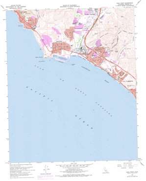
Dana Point Topo Map California
To zoom in, hover over the map of Dana Point
USGS Topo Quad 33117d6 - 1:24,000 scale
| Topo Map Name: | Dana Point |
| USGS Topo Quad ID: | 33117d6 |
| Print Size: | ca. 21 1/4" wide x 27" high |
| Southeast Coordinates: | 33.375° N latitude / 117.625° W longitude |
| Map Center Coordinates: | 33.4375° N latitude / 117.6875° W longitude |
| U.S. State: | CA |
| Filename: | o33117d6.jpg |
| Download Map JPG Image: | Dana Point topo map 1:24,000 scale |
| Map Type: | Topographic |
| Topo Series: | 7.5´ |
| Map Scale: | 1:24,000 |
| Source of Map Images: | United States Geological Survey (USGS) |
| Alternate Map Versions: |
Dana Point CA 1948, updated 1959 Download PDF Buy paper map Dana Point CA 1948, updated 1959 Download PDF Buy paper map Dana Point CA 1948, updated 1964 Download PDF Buy paper map Dana Point CA 1949, updated 1949 Download PDF Buy paper map Dana Point CA 1968, updated 1970 Download PDF Buy paper map Dana Point CA 1968, updated 1970 Download PDF Buy paper map Dana Point CA 1968, updated 1978 Download PDF Buy paper map Dana Point CA 1968, updated 1978 Download PDF Buy paper map Dana Point CA 1968, updated 1978 Download PDF Buy paper map Dana Point CA 1974, updated 1977 Download PDF Buy paper map Dana Point CA 2012 Download PDF Buy paper map Dana Point CA 2015 Download PDF Buy paper map |
1:24,000 Topo Quads surrounding Dana Point
> Back to 33117a1 at 1:100,000 scale
> Back to 33116a1 at 1:250,000 scale
> Back to U.S. Topo Maps home
Dana Point topo map: Gazetteer
Dana Point: Airports
Capistrano Airport (historical) elevation 15m 49′Dana Point: Arches
Three Arches elevation 7m 22′Dana Point: Bars
Crawfish Rock elevation 0m 0′Dana Point: Bays
Capistrano Bight elevation 0m 0′Dana Cove elevation 0m 0′
Mussel Cove elevation 0m 0′
Dana Point: Beaches
Poche Beach elevation 3m 9′San Clemente City Beach elevation 4m 13′
Dana Point: Capes
Dana Point elevation 15m 49′Dana Point: Cliffs
Coyote Bluff elevation 125m 410′Dana Point: Crossings
Exit 77 elevation 54m 177′Exit 78 elevation 66m 216′
Exit 79 elevation 49m 160′
Exit 81 elevation 27m 88′
Dana Point: Dams
Palisades Reservoir 1022-002 Dam elevation 122m 400′Dana Point: Harbors
Dana Point Harbor elevation 0m 0′East Basin elevation 3m 9′
West Basin elevation 3m 9′
Dana Point: Islands
San Juan Rocks elevation 0m 0′Dana Point: Parks
Arce Park elevation 26m 85′Bonita Park elevation 16m 52′
Capistrano Beach Park elevation 3m 9′
Dana Cove Park elevation 6m 19′
Dana Point Marine Life Refuge elevation 5m 16′
Del Obispo Community Park elevation 6m 19′
Descanso Park elevation 20m 65′
Doheny Marine Life Refuge elevation -3m -10′
Doheny State Beach elevation 5m 16′
Gazebo Park elevation 10m 32′
Good Neighbors Park elevation 26m 85′
Heritage Park elevation 35m 114′
Lantern Bay County Park elevation 34m 111′
Louise Leydon Park elevation 39m 127′
Mira Costa Park elevation 48m 157′
Mission Bell Park elevation 10m 32′
Niguel Marine Life Refuge elevation 2m 6′
Ocean Knoll Park elevation 30m 98′
Pines Park elevation 26m 85′
Salt Creek Beach Park elevation 6m 19′
San Gorgonio Park elevation 55m 180′
Sea Canyon Park elevation 56m 183′
Sea Terrace Community Park elevation 38m 124′
Sunset Park elevation 69m 226′
Thunderbird Park elevation 56m 183′
Dana Point: Populated Places
Beachwood Trailer Park elevation 12m 39′Capistrano Beach elevation 51m 167′
Capistrano Terrace Mobile Home Park elevation 34m 111′
Capistrano Valley Mobile Home Estates elevation 11m 36′
Dana Point elevation 44m 144′
Dana Point Marina Mobile Home Estates elevation 5m 16′
Rancho Alipaz Mobile Home Park elevation 24m 78′
Rancho del Avion Capistrano Mobile Home Park elevation 18m 59′
San Juan Mobile Home Estates elevation 23m 75′
Three Arch Bay elevation 56m 183′
Villa San Juan Mobile Home Park elevation 9m 29′
Dana Point: Post Offices
Dana Point Post Office elevation 46m 150′Dana Point: Reservoirs
Cook Reservoir elevation 76m 249′Krum Reservoir elevation 216m 708′
McCracken Reservoir elevation 123m 403′
Palisades Reservoir elevation 132m 433′
Reed Reservoir elevation 115m 377′
Dana Point: Ridges
Folsom Ridge elevation 199m 652′Dana Point: Streams
Arroyo Salado elevation 41m 134′Horno Creek elevation 25m 82′
Salt Creek elevation 0m 0′
San Juan Creek elevation 1m 3′
Trabuco Creek elevation 18m 59′
Dana Point: Valleys
Deep Canyon elevation 49m 160′Prima Deshecha Canada elevation 2m 6′
Reservoir Canyon elevation 69m 226′
Segunda Deshecha Cañada elevation 2m 6′
Dana Point digital topo map on disk
Buy this Dana Point topo map showing relief, roads, GPS coordinates and other geographical features, as a high-resolution digital map file on DVD:


