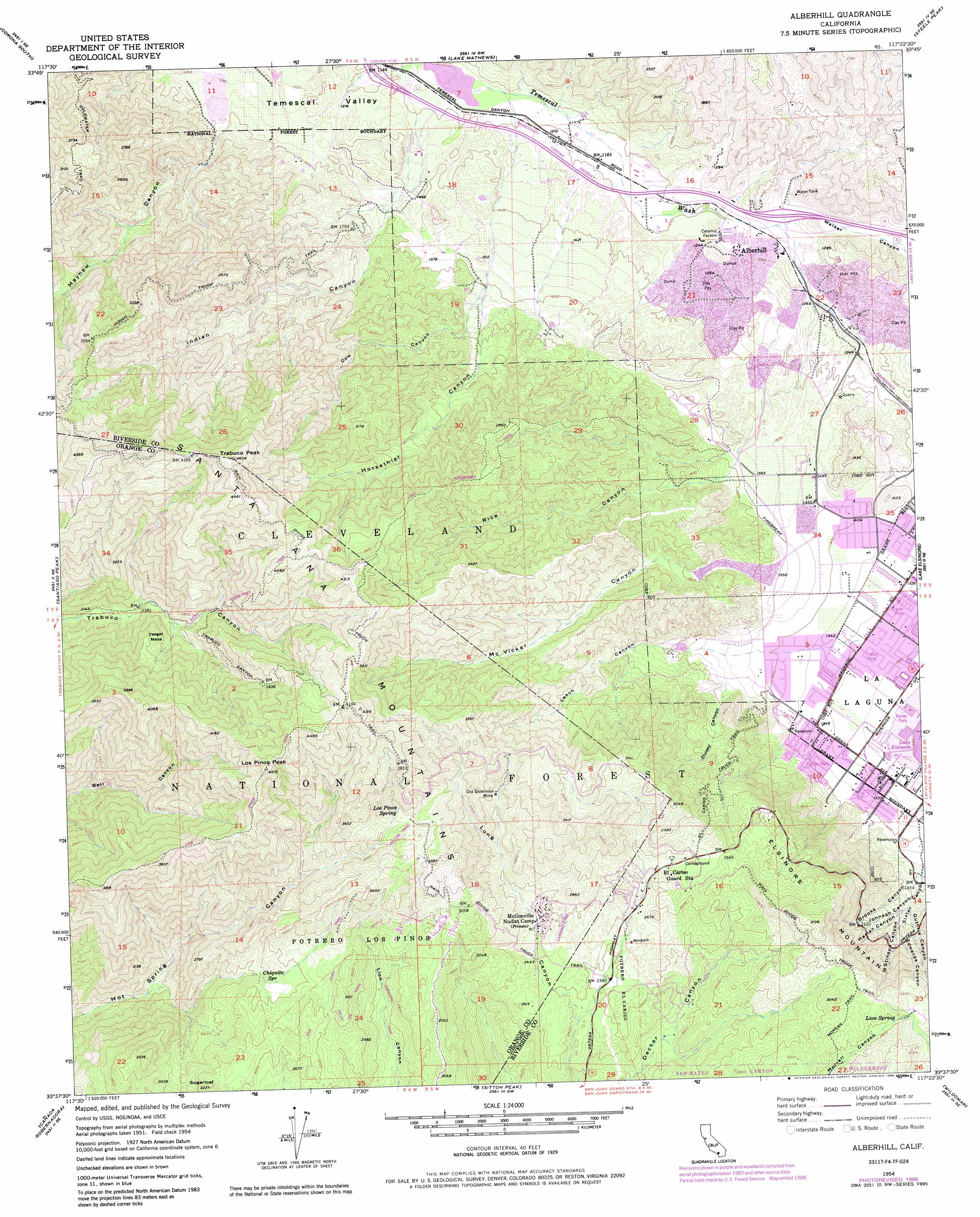
Alberhill Topo Map California
To zoom in, hover over the map of Alberhill
USGS Topo Quad 33117f4 - 1:24,000 scale
| Topo Map Name: | Alberhill |
| USGS Topo Quad ID: | 33117f4 |
| Print Size: | ca. 21 1/4" wide x 27" high |
| Southeast Coordinates: | 33.625° N latitude / 117.375° W longitude |
| Map Center Coordinates: | 33.6875° N latitude / 117.4375° W longitude |
| U.S. State: | CA |
| Filename: | o33117f4.jpg |
| Download Map JPG Image: | Alberhill topo map 1:24,000 scale |
| Map Type: | Topographic |
| Topo Series: | 7.5´ |
| Map Scale: | 1:24,000 |
| Source of Map Images: | United States Geological Survey (USGS) |
| Alternate Map Versions: |
Alberhill CA 1954, updated 1955 Download PDF Buy paper map Alberhill CA 1954, updated 1957 Download PDF Buy paper map Alberhill CA 1954, updated 1967 Download PDF Buy paper map Alberhill CA 1954, updated 1967 Download PDF Buy paper map Alberhill CA 1954, updated 1975 Download PDF Buy paper map Alberhill CA 1954, updated 1985 Download PDF Buy paper map Alberhill CA 1954, updated 1988 Download PDF Buy paper map Alberhill CA 1974, updated 1977 Download PDF Buy paper map Alberhill CA 1997, updated 2000 Download PDF Buy paper map Alberhill CA 1997, updated 2001 Download PDF Buy paper map Alberhill CA 2012 Download PDF Buy paper map Alberhill CA 2015 Download PDF Buy paper map |
| FStopo: | US Forest Service topo Alberhill is available: Download FStopo PDF Download FStopo TIF |
1:24,000 Topo Quads surrounding Alberhill
Prado Dam |
Corona North |
Riverside West |
Riverside East |
Sunnymead |
Black Star Canyon |
Corona South |
Lake Mathews |
Steele Peak |
Perris |
El Toro |
Santiago Peak |
Alberhill |
Lake Elsinore |
Romoland |
San Juan Capistrano |
Canada Gobernadora * |
Sitton Peak |
Wildomar |
Murrieta |
Dana Point |
San Clemente |
Margarita Peak |
Fallbrook |
Temecula |
> Back to 33117e1 at 1:100,000 scale
> Back to 33116a1 at 1:250,000 scale
> Back to U.S. Topo Maps home
Alberhill topo map: Gazetteer
Alberhill: Crossings
Interchange 81 elevation 376m 1233′Interchange 85 elevation 353m 1158′
Alberhill: Mines
Old Dominion Mine elevation 877m 2877′Alberhill: Parks
Machado Park elevation 403m 1322′McVicker Park elevation 476m 1561′
Oak Tree Park elevation 466m 1528′
Summer Lake Park elevation 444m 1456′
Alberhill: Populated Places
Alberhill elevation 376m 1233′Alberhill: Springs
Chiquito Spring elevation 838m 2749′Lion Spring elevation 848m 2782′
Los Pinos Spring elevation 1016m 3333′
Alberhill: Summits
Los Pinos Peak elevation 1358m 4455′Sugarloaf elevation 975m 3198′
Trabuco Peak elevation 1406m 4612′
Yaeger Mesa elevation 918m 3011′
Alberhill: Trails
Cariso Truck Trail elevation 674m 2211′East Horsetheif Trail elevation 936m 3070′
El Cariso Nature Trail elevation 817m 2680′
Falcon Trail elevation 1015m 3330′
Horsethief Trail elevation 1233m 4045′
Indian Truck Trail elevation 853m 2798′
Main Divide Truck Trail elevation 1336m 4383′
Trabuco Canyon Trail elevation 1084m 3556′
Viejo Tie Trail elevation 872m 2860′
West Horsethief Trail elevation 957m 3139′
Alberhill: Valleys
Bishop Canyon elevation 488m 1601′Brooks Canyon elevation 474m 1555′
Cow Canyon elevation 540m 1771′
Dickey Canyon elevation 470m 1541′
Edwards Canyon elevation 597m 1958′
Guthrie Canyon elevation 529m 1735′
Harlan Canyon elevation 524m 1719′
Horsethief Canyon elevation 489m 1604′
Indian Canyon elevation 454m 1489′
Johnson Canyon elevation 513m 1683′
Leach Canyon elevation 437m 1433′
Mayhew Canyon elevation 411m 1348′
McVicker Canyon elevation 476m 1561′
Rice Canyon elevation 497m 1630′
Slater Canyon elevation 449m 1473′
Stinson Canyon elevation 540m 1771′
Walker Canyon elevation 378m 1240′
Alberhill digital topo map on disk
Buy this Alberhill topo map showing relief, roads, GPS coordinates and other geographical features, as a high-resolution digital map file on DVD: