Tustin Topo Map California
To zoom in, hover over the map of Tustin
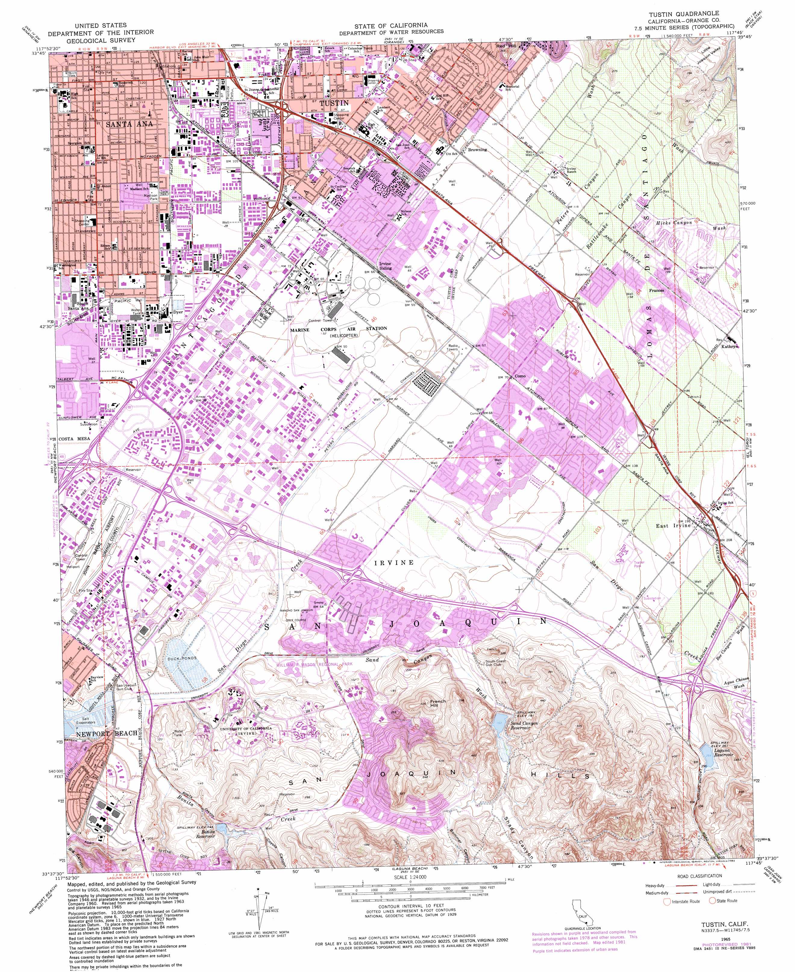
USGS Topo Quad 33117f7 - 1:24,000 scale
| Topo Map Name: | Tustin |
| USGS Topo Quad ID: | 33117f7 |
| Print Size: | ca. 21 1/4" wide x 27" high |
| Southeast Coordinates: | 33.625° N latitude / 117.75° W longitude |
| Map Center Coordinates: | 33.6875° N latitude / 117.8125° W longitude |
| U.S. State: | CA |
| Filename: | o33117f7.jpg |
| Download Map JPG Image: | Tustin topo map 1:24,000 scale |
| Map Type: | Topographic |
| Topo Series: | 7.5´ |
| Map Scale: | 1:24,000 |
| Source of Map Images: | United States Geological Survey (USGS) |
| Alternate Map Versions: |
Tustin CA 1948, updated 1957 Download PDF Buy paper map Tustin CA 1948, updated 1962 Download PDF Buy paper map Tustin CA 1950, updated 1950 Download PDF Buy paper map Tustin CA 1962, updated 1975 Download PDF Buy paper map Tustin CA 1965, updated 1967 Download PDF Buy paper map Tustin CA 1965, updated 1982 Download PDF Buy paper map Tustin CA 1974, updated 1975 Download PDF Buy paper map Tustin CA 2012 Download PDF Buy paper map Tustin CA 2015 Download PDF Buy paper map |
1:24,000 Topo Quads surrounding Tustin
Whittier |
La Habra |
Yorba Linda |
Prado Dam |
Corona North |
Los Alamitos |
Anaheim |
Orange |
Black Star Canyon |
Corona South |
Seal Beach |
Newport Beach |
Tustin |
El Toro |
Santiago Peak |
Laguna Beach |
San Juan Capistrano |
Canada Gobernadora * |
||
Dana Point |
San Clemente |
> Back to 33117e1 at 1:100,000 scale
> Back to 33116a1 at 1:250,000 scale
> Back to U.S. Topo Maps home
Tustin topo map: Gazetteer
Tustin: Airports
Baldwin Base Heliport elevation 13m 42′Jamboree Center Helistop elevation 11m 36′
John Wayne Airport elevation 15m 49′
Martins Landing Field (historical) elevation 11m 36′
Park Place Heliport elevation 11m 36′
Rogerson Building Heliport elevation 12m 39′
SCE Southeastern Division Heliport elevation 30m 98′
The Atrium Heliport elevation 14m 45′
Tustin: Canals
Culver Storm Channel elevation 14m 45′El Modena Irvine Channel elevation 38m 124′
Peters Canyon Channel elevation 13m 42′
Tustin: Crossings
Exit 100 elevation 25m 82′Exit 101A elevation 25m 82′
Exit 101B elevation 35m 114′
Exit 102 elevation 40m 131′
Exit 103 elevation 38m 124′
Exit 104A elevation 37m 121′
Exit 10A elevation 33m 108′
Exit 10B elevation 36m 118′
Exit 11A elevation 37m 121′
Exit 11B elevation 39m 127′
Exit 2 elevation 58m 190′
Exit 3 elevation 48m 157′
Exit 4 elevation 35m 114′
Exit 5 elevation 18m 59′
Exit 6A elevation 11m 36′
Exit 6B elevation 11m 36′
Exit 7 elevation 12m 39′
Exit 7 elevation 13m 42′
Exit 8 elevation 10m 32′
Exit 8 elevation 17m 55′
Exit 9 elevation 33m 108′
Exit 95 elevation 68m 223′
Exit 96 elevation 69m 226′
Exit 97 elevation 49m 160′
Exit 99 elevation 33m 108′
Exit 9A elevation 11m 36′
Tustin: Dams
Bonita Canyon 793-004 Dam elevation 43m 141′Laguna 793-005 Dam elevation 79m 259′
Sand Canyon 1029-002 Dam elevation 50m 164′
Tustin: Parks
Alderwood Park elevation 65m 213′Aldrich Park elevation 24m 78′
Arrowhead Park elevation 24m 78′
Birch Park elevation 34m 111′
Birdsong Park elevation 24m 78′
Blue Gum Park elevation 59m 193′
Blue Jay Park elevation 22m 72′
Bonita Creek Park elevation 6m 19′
Brywood Park elevation 45m 147′
Canyon Park elevation 75m 246′
Carrotwood Park elevation 63m 206′
Centennial Park elevation 24m 78′
Chaparral Park elevation 106m 347′
College Park elevation 21m 68′
Columbus Tustin Park elevation 43m 141′
Coralwood Park elevation 45m 147′
Crestwood Park elevation 51m 167′
Culverdale Wilderness Park elevation 14m 45′
Culverwood Wilderness Park elevation 16m 52′
Deerfield Community Park elevation 24m 78′
Delhi Park elevation 18m 59′
Downtown Santa Ana Historic District elevation 38m 124′
Flagstone Park elevation 21m 68′
Frontier Park elevation 32m 104′
Heritage Park elevation 37m 121′
Hoeptner Park elevation 39m 127′
Lemongrass Park elevation 26m 85′
Lillie King Park elevation 12m 39′
Madison Park elevation 26m 85′
Magnolia Park elevation 22m 72′
North Lake Park elevation 29m 95′
Northwood Community Park elevation 53m 173′
Pepper Tree Park elevation 42m 137′
Pepperwood Park elevation 53m 173′
Pine Tree Park elevation 34m 111′
Prentice Park elevation 39m 127′
Presley Park elevation 34m 111′
Ralph C Bren Memorial Park elevation 92m 301′
Ranch Park elevation 34m 111′
San Joaquin Freshwater Marsh Reserve elevation 2m 6′
Sandpointe Park elevation 10m 32′
Santa Ana Zoo elevation 39m 127′
Sasscer Park elevation 35m 114′
Shorebird Park elevation 27m 88′
Silkwood Park elevation 51m 167′
Stanford Park elevation 15m 49′
Stone Creek Park elevation 23m 75′
Sycamore Park elevation 52m 170′
Turtle Creek Community Park elevation 80m 262′
University Community Park elevation 28m 91′
Utt Park elevation 37m 121′
William R Mason Regional Park elevation 21m 68′
Willows Park elevation 30m 98′
Windrow Community Park elevation 35m 114′
Woodpine Park elevation 23m 75′
Yost Theatre (historical) elevation 37m 121′
Tustin: Populated Places
Aliso elevation 29m 95′Browning elevation 28m 91′
Como elevation 22m 72′
Dyer elevation 18m 59′
East Irvine elevation 60m 196′
Frances elevation 58m 190′
Irvine elevation 17m 55′
Kathryn elevation 71m 232′
Montesilla Mobile Home Club elevation 37m 121′
Myford elevation 38m 124′
Parque Santiago Mobile Home Park elevation 40m 131′
Rail-A-Way Trailer Park elevation 29m 95′
Saddleback Mobile Lodge elevation 38m 124′
Santa Ana elevation 35m 114′
South Santa Ana elevation 14m 45′
Standard Avenue Mobile Home Park elevation 26m 85′
The Meadows elevation 41m 134′
Tustin elevation 43m 141′
Tustin Village Mobile Home Club elevation 39m 127′
Villa Grande Mobile Home Park elevation 36m 118′
Villa Valencia elevation 27m 88′
Tustin: Post Offices
Tustin Post Office elevation 40m 131′Tustin: Reservoirs
Bonita Reservoir elevation 43m 141′Laguna Reservoir elevation 79m 259′
North Lake elevation 29m 95′
Sand Canyon Reservoir elevation 50m 164′
Tustin: Streams
Agua Chinon Wash elevation 52m 170′Bee Canyon Wash elevation 52m 170′
Bonita Creek elevation 4m 13′
Hicks Canyon Wash elevation 47m 154′
Peters Canyon Wash elevation 16m 52′
Rattlesnake Canyon Wash elevation 25m 82′
San Diego Creek elevation 0m 0′
Sand Canyon Wash elevation 6m 19′
Tustin: Summits
French Hill elevation 121m 396′Red Hill elevation 79m 259′
Tustin: Valleys
Bommer Canyon elevation 61m 200′Coyote Canyon elevation 47m 154′
Little Joaquin Valley elevation 95m 311′
Shady Canyon elevation 59m 193′
Tustin digital topo map on disk
Buy this Tustin topo map showing relief, roads, GPS coordinates and other geographical features, as a high-resolution digital map file on DVD: