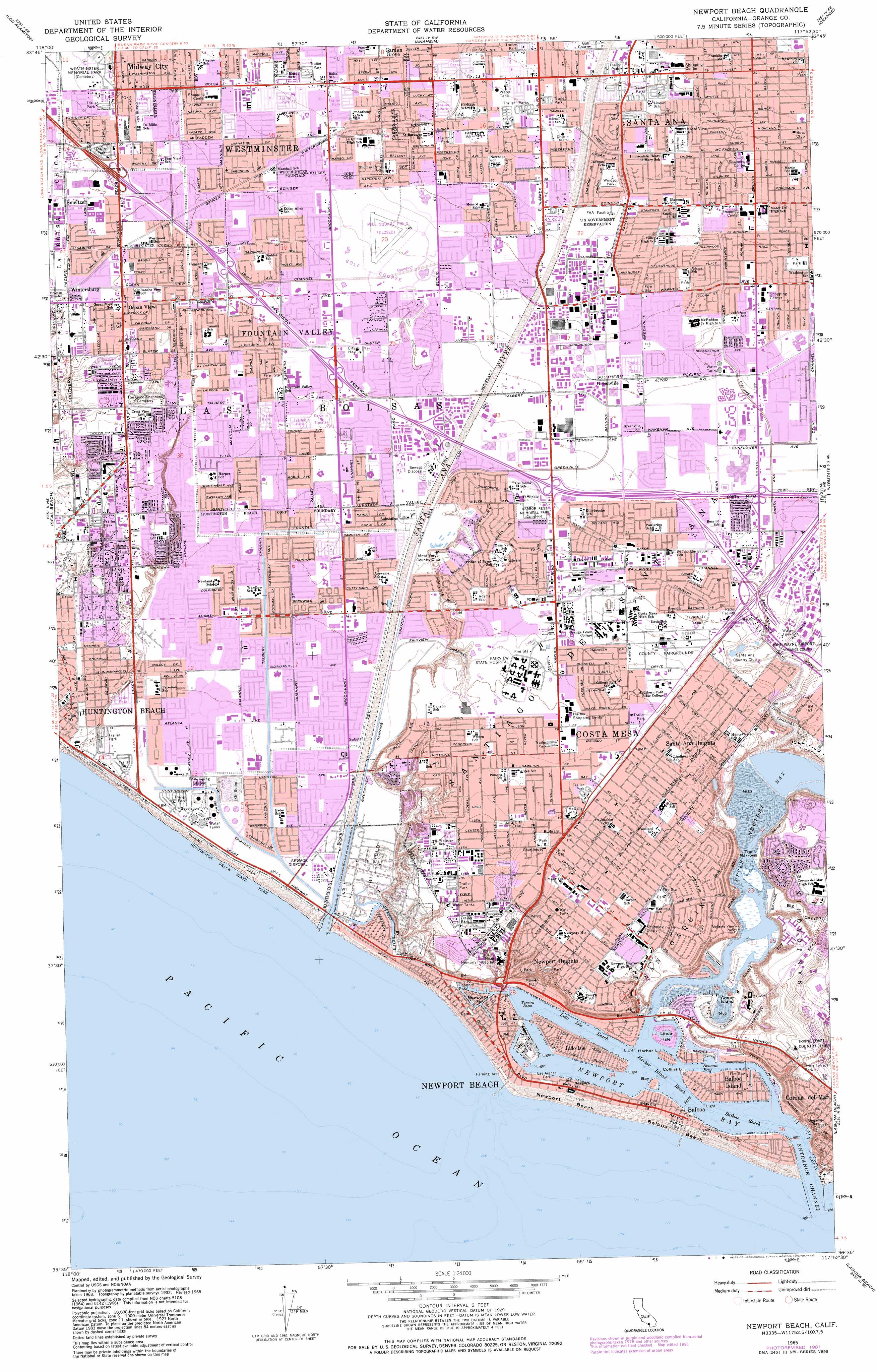
Newport Beach Topo Map California
To zoom in, hover over the map of Newport Beach
USGS Topo Quad 33117f8 - 1:24,000 scale
| Topo Map Name: | Newport Beach |
| USGS Topo Quad ID: | 33117f8 |
| Print Size: | ca. 21 1/4" wide x 27" high |
| Southeast Coordinates: | 33.625° N latitude / 117.875° W longitude |
| Map Center Coordinates: | 33.6875° N latitude / 117.9375° W longitude |
| U.S. State: | CA |
| Filename: | o33117f8.jpg |
| Download Map JPG Image: | Newport Beach topo map 1:24,000 scale |
| Map Type: | Topographic |
| Topo Series: | 7.5´ |
| Map Scale: | 1:24,000 |
| Source of Map Images: | United States Geological Survey (USGS) |
| Alternate Map Versions: |
Costa Mesa CA 1974, updated 1975 Download PDF Buy paper map Newport Beach CA 1974, updated 1977 Download PDF Buy paper map Newport Beach CA 2012 Download PDF Buy paper map Newport Beach CA 2015 Download PDF Buy paper map |
1:24,000 Topo Quads surrounding Newport Beach
South Gate |
Whittier |
La Habra |
Yorba Linda |
Prado Dam |
Long Beach |
Los Alamitos |
Anaheim |
Orange |
Black Star Canyon |
Seal Beach |
Newport Beach |
Tustin |
El Toro |
|
Laguna Beach |
San Juan Capistrano |
|||
Dana Point |
> Back to 33117e1 at 1:100,000 scale
> Back to 33116a1 at 1:250,000 scale
> Back to U.S. Topo Maps home
Newport Beach topo map: Gazetteer
Newport Beach: Airports
Bank of America-Metro Center Heliport elevation 10m 32′Costa Mesa Police Department Heliport elevation 23m 75′
Fountain Valley Regional Hospital Heliport elevation 12m 39′
Huntington Beach Airport (historical) elevation 2m 6′
Los Angeles Times Costa Mesa Heliport elevation 9m 29′
Newport Beach Police Heliport elevation 29m 95′
Newport Beach: Bays
Upper Newport Bay elevation 0m 0′Newport Beach: Beaches
Huntington City Beach elevation 4m 13′North Star Beach elevation 3m 9′
Newport Beach: Canals
East Garden Grove Wintersburg Channel elevation 7m 22′Fairview Channel elevation 2m 6′
Fountain Valley Channel elevation 4m 13′
Greenville Banning Channel elevation 7m 22′
Huntington Beach Channel elevation 0m 0′
Paularino Channel elevation 11m 36′
Santa Ana Delhi Channel elevation 10m 32′
Santa Ana Gardens Channel elevation 10m 32′
Talbert Channel elevation 2m 6′
Newport Beach: Crossings
Exit 11A elevation 10m 32′Exit 11B elevation 8m 26′
Exit 12 elevation 9m 29′
Exit 14 elevation 9m 29′
Exit 15A elevation 8m 26′
Exit 15B elevation 8m 26′
Exit 16 elevation 14m 45′
Exit 17A elevation 11m 36′
Exit 17B elevation 8m 26′
Exit 17C elevation 12m 39′
Exit 3 elevation 26m 85′
Exit 4 elevation 22m 72′
Exit 5A elevation 14m 45′
Exit 5B elevation 11m 36′
Exit 9B elevation 9m 29′
Newport Beach: Gaps
The Narrows elevation 0m 0′Newport Beach: Parks
Adams Park elevation 14m 45′Alevalos Park elevation 5m 16′
Allen Park elevation 11m 36′
Angels Community Park elevation 32m 104′
Bartlett Park elevation 7m 22′
Bomo Koral Park elevation 10m 32′
Burke Park elevation 3m 9′
Bushard Park elevation 4m 13′
Canyon Park elevation 13m 42′
Carl Thornton Park elevation 8m 26′
Centennial Regional Park elevation 18m 59′
Center Park elevation 24m 78′
Civic Center Park elevation 22m 72′
College Park elevation 12m 39′
Cordata Park elevation 4m 13′
Coronet Park elevation 13m 42′
Courreges Park elevation 6m 19′
Del Mesa Park elevation 13m 42′
Drew Park elevation 3m 9′
East Bluff Park elevation 32m 104′
Edison Community Park elevation 2m 6′
Elden F Gillespie Park elevation 13m 42′
Ellis Park elevation 7m 22′
Estancia Park elevation 21m 68′
Fairview Park elevation 4m 13′
Flower Street Park elevation 31m 101′
Fountain Valley Park elevation 8m 26′
Friendship Park elevation 23m 75′
Fulton Park elevation 8m 26′
Galaxie View Park elevation 33m 108′
Gisler Park elevation 9m 29′
Gisler Park elevation 3m 9′
Green Valley Park elevation 9m 29′
Griset Park elevation 11m 36′
Harbor Rest Memorial Park elevation 12m 39′
Harper Park elevation 5m 16′
Harper Park elevation 28m 91′
Hawes Park elevation 3m 9′
Heller Park elevation 31m 101′
Helm Park elevation 4m 13′
Helme Park elevation 18m 59′
Heritage Park elevation 10m 32′
Huntington State Beach elevation 4m 13′
Jerome Park elevation 20m 65′
La Capilla Park elevation 10m 32′
Lake Park elevation 10m 32′
Lake View Park elevation 8m 26′
Lambert Park elevation 18m 59′
Land Park elevation 10m 32′
LeBard Park elevation 3m 9′
LeBard Stadium elevation 15m 49′
Lindbergh School Park elevation 24m 78′
Lions Park elevation 28m 91′
Los Alamos Park elevation 9m 29′
Manning Park elevation 7m 22′
Marina View Park elevation 15m 49′
Mariners Park elevation 25m 82′
McCallen Park elevation 11m 36′
Mesa Verde Park elevation 19m 62′
Mile Square Regional Park elevation 14m 45′
Moffett Park elevation 3m 9′
Monroe Park elevation 16m 52′
Newcastle Park elevation 17m 55′
Newland Park elevation 3m 9′
Oak View Center Park elevation 11m 36′
Oak View Park elevation 10m 32′
Orange County Fairgrounds elevation 20m 65′
Park West Park elevation 10m 32′
Paularino Park elevation 10m 32′
Perry Park elevation 19m 62′
Pinkley Park elevation 30m 98′
Plavan Park elevation 9m 29′
Pleasant View Park elevation 8m 26′
Roger Stanton Park elevation 13m 42′
Santa Ana River County Beach elevation 4m 13′
Santa Anita Park elevation 22m 72′
Seeley Park elevation 3m 9′
Shiffer Park elevation 10m 32′
Smallwood Park elevation 13m 42′
Sowers Park elevation 2m 6′
Spurgeon Park elevation 26m 85′
Stonecress Park elevation 12m 39′
Suburbia Park elevation 8m 26′
Talbert Park elevation 3m 9′
Talbert Regional Park elevation 2m 6′
Tanager Park elevation 20m 65′
Te Winkle Park elevation 20m 65′
Terry Park elevation 17m 55′
Tustin Park elevation 27m 88′
Upper Newport Bay Ecological Reserve elevation 3m 9′
Victoria Vista Park elevation 27m 88′
Vista View Park elevation 10m 32′
Wakeman Park elevation 10m 32′
Wardlow Park elevation 3m 9′
West Newport Park elevation 4m 13′
Westmont Park elevation 8m 26′
Wilson Street Park elevation 24m 78′
Wimbleton Park elevation 10m 32′
Windsor Park elevation 19m 62′
Newport Beach: Populated Places
Bali-Hi Mobile Home Lodge elevation 20m 65′Bit-O-Home Trailer Park elevation 18m 59′
Bolsa elevation 16m 52′
Bolsa Verde elevation 14m 45′
Boulevard Gardens elevation 8m 26′
Brookfield Manor Mobile Home Park elevation 3m 9′
California Mobile Home Park elevation 24m 78′
Caravana Trailer Lodge elevation 15m 49′
Cliff Haven elevation 29m 95′
Coach Royal Trailer Park elevation 22m 72′
Colonia Juarez elevation 11m 36′
Costa Mesa elevation 30m 98′
Costa Mesa Mobile Home Estates elevation 24m 78′
Del Prado Bolsa elevation 12m 39′
Driftwood Mobile Home Park elevation 8m 26′
Ebbtide Mobile Home Park elevation 32m 104′
El Nido Mobile Home Estates elevation 28m 91′
Fairview Mobile Home Estates elevation 24m 78′
Fountain Valley elevation 10m 32′
Fountain Valley Mobile Home Estates elevation 5m 16′
Gardners Trailer Park elevation 23m 75′
Greenleaf Mobile Home Park elevation 32m 104′
Harbor Mobile Home Park elevation 31m 101′
Hoosier Trailer Court elevation 26m 85′
Huntington Beach elevation 12m 39′
Huntington Mobile Home Estates elevation 17m 55′
Huntington Shorecliffs Mobile Home Park elevation 2m 6′
Hyde Park Mobile Home Estates elevation 23m 75′
Island View Trailer Park elevation 33m 108′
Kensington Gardens elevation 15m 49′
Kona Kai Mobile Home Park elevation 20m 65′
La Bolsa elevation 20m 65′
Lake Park Santa Ana elevation 22m 72′
Liberty Mobile Home Court elevation 21m 68′
Liberty Park elevation 8m 26′
Midway City elevation 12m 39′
Newport Terrace Mobile Home Park elevation 31m 101′
Ocean View elevation 9m 29′
Pacific Trailer Park elevation 3m 9′
Paularino elevation 13m 42′
Play Port Mobile Home Village elevation 33m 108′
Plaza Mobile Home Estates elevation 11m 36′
Ponderosa Mobile Home Park elevation 27m 88′
Quiet Village Mobile Home Park elevation 22m 72′
Rancho del Sol Mobile Home Park elevation 16m 52′
Rancho Huntington Mobile Home Park elevation 2m 6′
Rancho La Siesta Mobile Home Park elevation 7m 22′
Regal Mobile Club Estates elevation 31m 101′
Royal Gardens Mobile Home Estates elevation 16m 52′
Sandalwood Mobile Home Park elevation 19m 62′
Santa Ana Gardens elevation 17m 55′
Santa Ana Heights elevation 21m 68′
Seacliffe Mobile Home Park elevation 31m 101′
Smeltzer elevation 8m 26′
Snug Harbor Trailer Park elevation 28m 91′
Stoneridge Mobile Home Park elevation 20m 65′
Sugar (historical) elevation 14m 45′
Taggin Wagon Mobile Home Park elevation 25m 82′
Talbert elevation 8m 26′
The Gables elevation 21m 68′
Thurin elevation 25m 82′
Town and Country Villa elevation 23m 75′
Tradewinds Trailer Village elevation 24m 78′
Villa Huntington Mobile Home Park elevation 8m 26′
Villa Magnolia Mobile Home Park elevation 13m 42′
Wintersburg elevation 9m 29′
Newport Beach: Post Offices
Bolsa Station Westminster Post Office elevation 14m 45′Huntington Beach Post Office elevation 11m 36′
Midway City Post Office elevation 12m 39′
Newport Beach: Streams
Santa Ana River elevation 0m 0′Newport Beach: Valleys
Big Canyon elevation 2m 6′Newport Beach digital topo map on disk
Buy this Newport Beach topo map showing relief, roads, GPS coordinates and other geographical features, as a high-resolution digital map file on DVD: