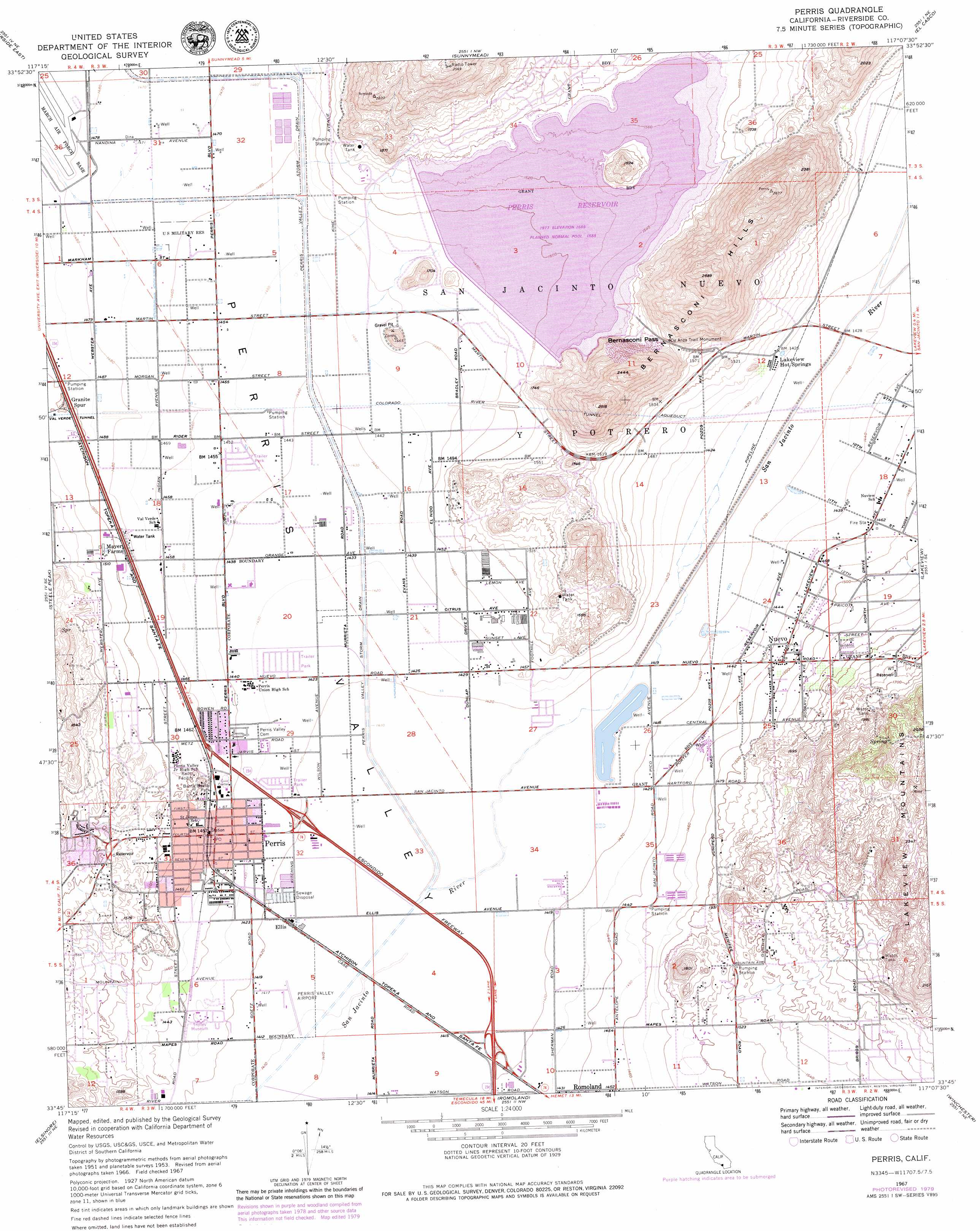
Perris Topo Map California
To zoom in, hover over the map of Perris
USGS Topo Quad 33117g2 - 1:24,000 scale
| Topo Map Name: | Perris |
| USGS Topo Quad ID: | 33117g2 |
| Print Size: | ca. 21 1/4" wide x 27" high |
| Southeast Coordinates: | 33.75° N latitude / 117.125° W longitude |
| Map Center Coordinates: | 33.8125° N latitude / 117.1875° W longitude |
| U.S. State: | CA |
| Filename: | o33117g2.jpg |
| Download Map JPG Image: | Perris topo map 1:24,000 scale |
| Map Type: | Topographic |
| Topo Series: | 7.5´ |
| Map Scale: | 1:24,000 |
| Source of Map Images: | United States Geological Survey (USGS) |
| Alternate Map Versions: |
Perris CA 1953, updated 1954 Download PDF Buy paper map Perris CA 1953, updated 1961 Download PDF Buy paper map Perris CA 1967, updated 1969 Download PDF Buy paper map Perris CA 1967, updated 1975 Download PDF Buy paper map Perris CA 1967, updated 1980 Download PDF Buy paper map Perris CA 1967, updated 1980 Download PDF Buy paper map Perris CA 2012 Download PDF Buy paper map Perris CA 2015 Download PDF Buy paper map |
1:24,000 Topo Quads surrounding Perris
Fontana |
San Bernardino South |
Redlands |
Yucaipa |
Forest Falls |
Riverside West |
Riverside East |
Sunnymead |
El Casco |
Beaumont |
Lake Mathews |
Steele Peak |
Perris |
Lakeview |
San Jacinto |
Alberhill |
Lake Elsinore |
Romoland |
Winchester |
Hemet |
Sitton Peak |
Wildomar |
Murrieta |
Bachelor Mountain |
Sage |
> Back to 33117e1 at 1:100,000 scale
> Back to 33116a1 at 1:250,000 scale
> Back to U.S. Topo Maps home
Perris topo map: Gazetteer
Perris: Airports
Castle Heliport elevation 459m 1505′Perris Valley Airport elevation 431m 1414′
SCE Perris District Heliport elevation 435m 1427′
Perris: Basins
Perris Valley elevation 432m 1417′Perris: Bays
Bernasconi Bay elevation 482m 1581′Big Rock Bay elevation 478m 1568′
Perris: Beaches
Bernasconi Beach elevation 486m 1594′Moreno Beach elevation 485m 1591′
Perris Beach elevation 488m 1601′
Perris: Canals
Perris Valley Storm Drain elevation 442m 1450′Perris: Crossings
Interchange 15 elevation 438m 1437′Interchange 17 elevation 434m 1423′
Interchange 18 elevation 445m 1459′
Interchange 19 elevation 446m 1463′
Perris: Dams
Perris 1-068 Dam elevation 478m 1568′Perris: Gaps
Bernasconi Pass elevation 521m 1709′Perris: Islands
Alessandro Island elevation 531m 1742′Perris: Parks
Banta Beatty Park elevation 445m 1459′Lake Perris State Recreation Area elevation 478m 1568′
Woodhaven Park elevation 438m 1437′
Perris: Pillars
De Anza Trail Monument elevation 538m 1765′Perris: Populated Places
Ellis elevation 433m 1420′Lakeview Hot Springs elevation 436m 1430′
Nuevo elevation 454m 1489′
Perris elevation 443m 1453′
Rancho las Perris elevation 436m 1430′
Perris: Post Offices
Nuevo Post Office elevation 452m 1482′Perris: Ranges
Bernasconi Hills elevation 776m 2545′Perris: Reservoirs
Perris Reservoir elevation 478m 1568′Ski Land Lake elevation 431m 1414′
Perris: Summits
Coney Hill elevation 498m 1633′Perris digital topo map on disk
Buy this Perris topo map showing relief, roads, GPS coordinates and other geographical features, as a high-resolution digital map file on DVD: