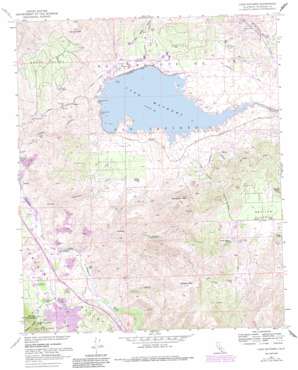
Lake Mathews Topo Map California
To zoom in, hover over the map of Lake Mathews
USGS Topo Quad 33117g4 - 1:24,000 scale
| Topo Map Name: | Lake Mathews |
| USGS Topo Quad ID: | 33117g4 |
| Print Size: | ca. 21 1/4" wide x 27" high |
| Southeast Coordinates: | 33.75° N latitude / 117.375° W longitude |
| Map Center Coordinates: | 33.8125° N latitude / 117.4375° W longitude |
| U.S. State: | CA |
| Filename: | o33117g4.jpg |
| Download Map JPG Image: | Lake Mathews topo map 1:24,000 scale |
| Map Type: | Topographic |
| Topo Series: | 7.5´ |
| Map Scale: | 1:24,000 |
| Source of Map Images: | United States Geological Survey (USGS) |
| Alternate Map Versions: |
Lake Mathews CA 1953, updated 1955 Download PDF Buy paper map Lake Mathews CA 1953, updated 1958 Download PDF Buy paper map Lake Mathews CA 1967, updated 1969 Download PDF Buy paper map Lake Mathews CA 1967, updated 1975 Download PDF Buy paper map Lake Mathews CA 1967, updated 1984 Download PDF Buy paper map Lake Mathews CA 1967, updated 1988 Download PDF Buy paper map Lake Mathews CA 1974, updated 1975 Download PDF Buy paper map Lake Mathews CA 1997, updated 2000 Download PDF Buy paper map Lake Mathews CA 2012 Download PDF Buy paper map Lake Mathews CA 2015 Download PDF Buy paper map |
| FStopo: | US Forest Service topo Lake Mathews is available: Download FStopo PDF Download FStopo TIF |
1:24,000 Topo Quads surrounding Lake Mathews
> Back to 33117e1 at 1:100,000 scale
> Back to 33116a1 at 1:250,000 scale
> Back to U.S. Topo Maps home
Lake Mathews topo map: Gazetteer
Lake Mathews: Airports
Lake Mathews Airport elevation 425m 1394′SCE Palm Springs District Heliport elevation 367m 1204′
Lake Mathews: Basins
Eagle Valley elevation 391m 1282′Lake Mathews: Crossings
Interchange 88 elevation 310m 1017′Lake Mathews: Dams
Lee Lake 818-002 Dam elevation 347m 1138′Mathews Dam elevation 424m 1391′
Lake Mathews: Lakes
Lee Lake elevation 347m 1138′Lake Mathews: Levees
Mathews Dike elevation 428m 1404′Lake Mathews: Mines
Cajalco Tin Mine elevation 369m 1210′Lake Mathews: Parks
Indian Pictographs Historical Marker elevation 289m 948′Lake Mathews Ecological Reserve elevation 443m 1453′
Lake Mathews: Plains
Gavilan Plateau elevation 635m 2083′Lake Mathews: Populated Places
Arcilla elevation 292m 958′Temescal elevation 339m 1112′
Weisel elevation 278m 912′
Lake Mathews: Reservoirs
Lake Mathews elevation 424m 1391′Lake Mathews: Summits
Arington Mountain elevation 557m 1827′Black Rocks elevation 481m 1578′
Estelle Mountain elevation 842m 2762′
Gavilan Peak elevation 737m 2417′
Monument Peak elevation 699m 2293′
Lake Mathews: Tunnels
Cajalco Tunnel elevation 438m 1437′Lake Mathews: Valleys
Cajalco Canyon elevation 256m 839′Coldwater Canyon elevation 374m 1227′
Dawson Canyon elevation 301m 987′
Olsen Canyon elevation 279m 915′
Lake Mathews digital topo map on disk
Buy this Lake Mathews topo map showing relief, roads, GPS coordinates and other geographical features, as a high-resolution digital map file on DVD:


