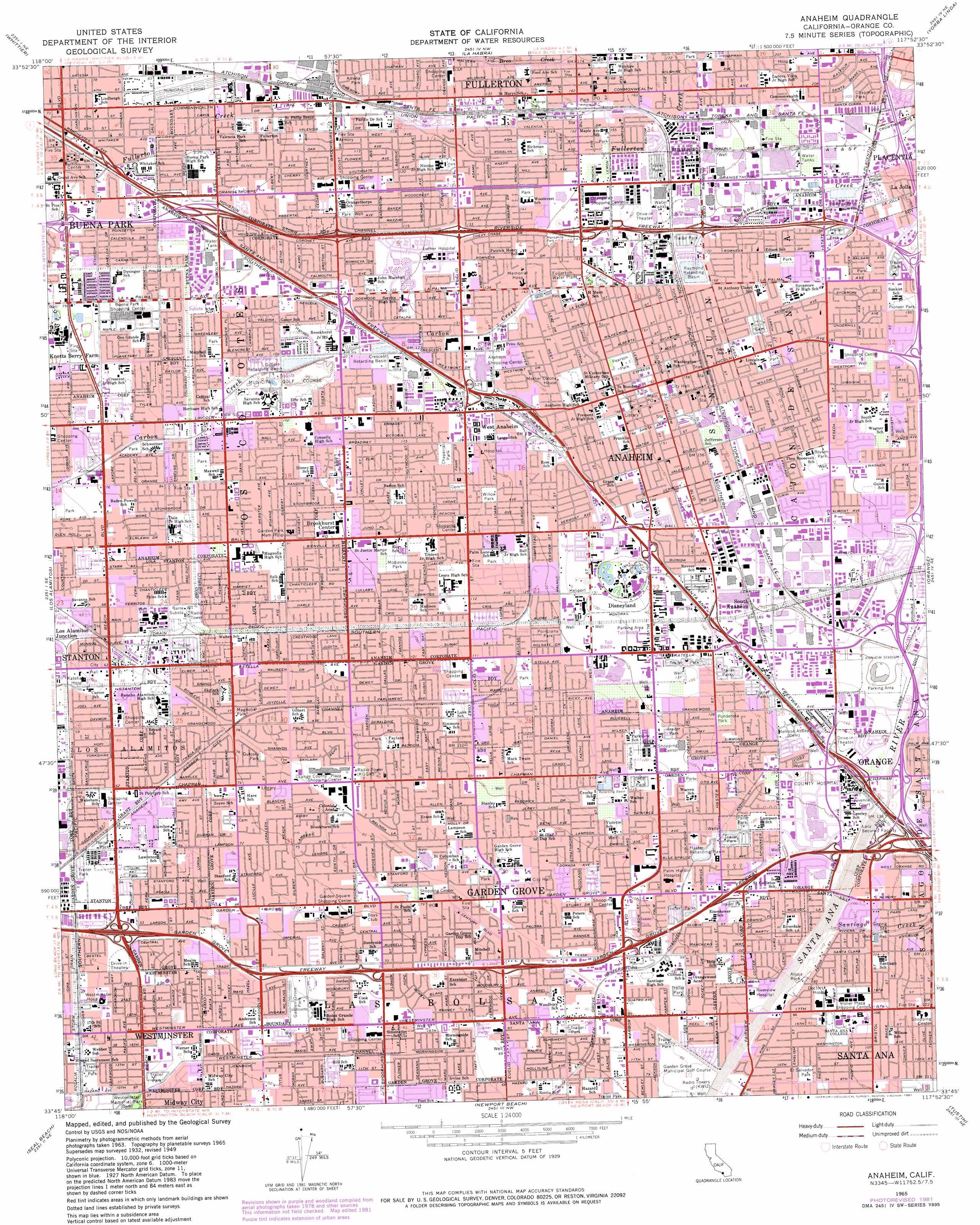
Anaheim Topo Map California
To zoom in, hover over the map of Anaheim
USGS Topo Quad 33117g8 - 1:24,000 scale
| Topo Map Name: | Anaheim |
| USGS Topo Quad ID: | 33117g8 |
| Print Size: | ca. 21 1/4" wide x 27" high |
| Southeast Coordinates: | 33.75° N latitude / 117.875° W longitude |
| Map Center Coordinates: | 33.8125° N latitude / 117.9375° W longitude |
| U.S. State: | CA |
| Filename: | o33117g8.jpg |
| Download Map JPG Image: | Anaheim topo map 1:24,000 scale |
| Map Type: | Topographic |
| Topo Series: | 7.5´ |
| Map Scale: | 1:24,000 |
| Source of Map Images: | United States Geological Survey (USGS) |
| Alternate Map Versions: |
Anaheim CA 1949, updated 1956 Download PDF Buy paper map Anaheim CA 1950 Download PDF Buy paper map Anaheim CA 1965, updated 1967 Download PDF Buy paper map Anaheim CA 1965, updated 1972 Download PDF Buy paper map Anaheim CA 1965, updated 1981 Download PDF Buy paper map Anaheim CA 1974, updated 1977 Download PDF Buy paper map Anaheim CA 2012 Download PDF Buy paper map Anaheim CA 2015 Download PDF Buy paper map |
1:24,000 Topo Quads surrounding Anaheim
Los Angeles |
El Monte |
Baldwin Park |
San Dimas |
Ontario |
South Gate |
Whittier |
La Habra |
Yorba Linda |
Prado Dam |
Long Beach |
Los Alamitos |
Anaheim |
Orange |
Black Star Canyon |
Seal Beach |
Newport Beach |
Tustin |
El Toro |
|
Laguna Beach |
San Juan Capistrano |
> Back to 33117e1 at 1:100,000 scale
> Back to 33116a1 at 1:250,000 scale
> Back to U.S. Topo Maps home
Anaheim topo map: Gazetteer
Anaheim: Airports
Albalisa Dinner Playhouse Incorporated Heliport elevation 29m 95′Anaheim Police Heliport elevation 50m 164′
Brian Chuchua Jeep Heliport elevation 60m 196′
Fullerton Municipal Airport elevation 28m 91′
Northrop Anaheim Heliport elevation 48m 157′
UCI Medical Center Heliport elevation 41m 134′
Anaheim: Canals
Barber City Channel elevation 19m 62′Morningside Drain elevation 19m 62′
Rosalia Storm Drain elevation 13m 42′
Westminster Channel elevation 16m 52′
Anaheim: Crossings
Exit 10 elevation 24m 78′Exit 107A elevation 43m 141′
Exit 107B elevation 43m 141′
Exit 107C elevation 46m 150′
Exit 109 elevation 49m 160′
Exit 11 elevation 31m 101′
Exit 110A elevation 49m 160′
Exit 110B elevation 42m 137′
Exit 111 elevation 41m 134′
Exit 112 elevation 42m 137′
Exit 113 elevation 39m 127′
Exit 114A elevation 30m 98′
Exit 114B elevation 28m 91′
Exit 115 elevation 24m 78′
Exit 116 elevation 21m 68′
Exit 12A elevation 33m 108′
Exit 12B elevation 31m 101′
Exit 13 elevation 34m 111′
Exit 14A elevation 42m 137′
Exit 14B elevation 39m 127′
Exit 14C elevation 46m 150′
Exit 1A elevation 42m 137′
Exit 1B elevation 44m 144′
Exit 2 elevation 49m 160′
Exit 23B elevation 24m 78′
Exit 24 elevation 27m 88′
Exit 26 elevation 35m 114′
Exit 27 elevation 45m 147′
Exit 28 elevation 43m 141′
Exit 29 elevation 54m 177′
Exit 3 elevation 55m 180′
Exit 30 elevation 61m 200′
Exit 4 elevation 61m 200′
Exit 5B elevation 61m 200′
Exit 6A elevation 63m 206′
Exit 6B elevation 70m 229′
Exit 8 elevation 20m 65′
Exit 9 elevation 23m 75′
Anaheim: Parks
Adlena Park elevation 37m 121′Alona Park elevation 31m 101′
Amerige Park elevation 46m 150′
Angel Stadium of Anaheim elevation 47m 154′
Barton Park elevation 34m 111′
Blakey Park elevation 16m 52′
Boisseranc Park elevation 27m 88′
Boysen Park elevation 53m 173′
Byerrum Park elevation 56m 183′
Chaparra Park elevation 37m 121′
Chapman Park elevation 63m 206′
Citrus Park elevation 50m 164′
Community Center Park elevation 28m 91′
Dee Field elevation 47m 154′
Eddie West Field elevation 34m 111′
Edison Park elevation 56m 183′
Edna Park elevation 31m 101′
El Salvador Park elevation 27m 88′
Euclid Park elevation 28m 91′
Faylane Park elevation 29m 95′
Fisher Park elevation 40m 131′
Ford Park elevation 48m 157′
Garden Grove Park elevation 19m 62′
Gilbert Park elevation 32m 104′
Glover Stadium elevation 47m 154′
Grand Park elevation 43m 141′
Gutosky Park elevation 25m 82′
Hansen Park elevation 34m 111′
Hare School Park elevation 24m 78′
Heritage Park elevation 10m 32′
Independence Park of Fullerton elevation 41m 134′
John Marshall Park elevation 37m 121′
Juarez Park elevation 56m 183′
Julianna Park elevation 50m 164′
Kroger-Melrose Historic District elevation 49m 160′
La Palma Park elevation 46m 150′
Lake School Park elevation 33m 108′
Lemon Park elevation 46m 150′
Leonard Park elevation 40m 131′
Liberty Park elevation 11m 36′
Lincoln Park elevation 54m 177′
Little Peoples Park elevation 47m 154′
Magnolia Park elevation 21m 68′
Manzanita Park elevation 47m 154′
Maxwell Park elevation 28m 91′
Modjeska Park elevation 33m 108′
Nicolas Park elevation 40m 131′
Oasis Park elevation 15m 49′
Orangethorpe School Park elevation 35m 114′
Pacific Drive Park elevation 35m 114′
Palm Lane Park elevation 37m 121′
Pearson Park elevation 47m 154′
Peter Marshall Park elevation 30m 98′
Pioneer Park elevation 60m 196′
Pioneer Park elevation 38m 124′
Poinciana Park elevation 38m 124′
Ponderosa Park elevation 40m 131′
Reid Park elevation 22m 72′
Richman Park elevation 45m 147′
Rosita Park elevation 22m 72′
Santa Ana Municipal Stadium elevation 34m 111′
Santa Fe Park elevation 69m 226′
Schweitzer Park elevation 24m 78′
Sierra Park elevation 37m 121′
Stanton Park elevation 19m 62′
Stoddard Park elevation 36m 118′
Twin Lakes Park elevation 29m 95′
Valencia Park elevation 28m 91′
Vietnam War Memorial Park elevation 14m 45′
Westhaven Park elevation 33m 108′
Westminster Park elevation 16m 52′
William W Eldridge Park elevation 44m 144′
Willow Park elevation 37m 121′
Woodbury Park elevation 25m 82′
Woodcrest Park elevation 44m 144′
Anaheim: Populated Places
Almond elevation 28m 91′Americana Mobile Home Park elevation 17m 55′
Anaheim elevation 48m 157′
Anaheim Mobile Home Estates elevation 21m 68′
Anaheim Royal Mobile Home Park elevation 60m 196′
Anaheim Shores elevation 38m 124′
Bahia Trailer Villa elevation 32m 104′
Beach West Mobile Home Estates elevation 17m 55′
Berrydale Trailer Park elevation 34m 111′
Brookhurst elevation 38m 124′
Buena Park elevation 23m 75′
Casa Hermosa Mobile Home Park elevation 31m 101′
Cherokee Mobile Gardens elevation 22m 72′
Clair elevation 22m 72′
Colonia Manzanilla elevation 24m 78′
Del Prado Mobile Park Club elevation 29m 95′
Del Ray Mobile Home Estates elevation 43m 141′
Eldorado Mobile Home Estates elevation 32m 104′
Emerald Isle Mobile Home Park elevation 29m 95′
Fernwood Mobile Home Park elevation 20m 65′
Fuller Park elevation 27m 88′
Fullerton elevation 50m 164′
Garden Grove elevation 27m 88′
Goldcrest Mobile Home Club elevation 33m 108′
Golden Skies Mobile Home Park elevation 45m 147′
Green Lantern Village elevation 13m 42′
Katella Mobile Home Estates elevation 23m 75′
La Belle Fontane Estates elevation 24m 78′
La Jolla elevation 62m 203′
Los Alamitos Junction elevation 20m 65′
Meadowlark Mobile Home Estates elevation 27m 88′
Micaflores elevation 42m 137′
Miraflores (historical) elevation 48m 157′
Neff elevation 36m 118′
Nutwood elevation 33m 108′
Oasis Mobile Home Park elevation 36m 118′
Ocean Breeze Trailer Park elevation 19m 62′
Orangetree elevation 52m 170′
Palm Lodge Mobile Home Estates elevation 61m 200′
Park Royale elevation 43m 141′
Parque Pacifico Mobile Home Park elevation 18m 59′
Plantation Mobile Home Estates elevation 43m 141′
Ponderosa Mobile Home Estates elevation 42m 137′
Prado Verde Mobile Home Park elevation 16m 52′
Rancho Fullerton Mobile Home Estates elevation 37m 121′
Rancho La Paz elevation 50m 164′
Rancho Thirty-nine Mobile Home Park elevation 17m 55′
Sahara Mobile Home Park elevation 25m 82′
Santa Ysabel (historical) elevation 62m 203′
South Anaheim elevation 46m 150′
South Grove Mobile Home Estates elevation 22m 72′
Stanton elevation 20m 65′
Summerset Mobile Home Estates elevation 17m 55′
Sunkist Gardens elevation 52m 170′
Tree Mobile Home Park elevation 34m 111′
Villa Capri Mobile Home Park elevation 18m 59′
West Anaheim elevation 38m 124′
West Anaheim Junction elevation 44m 144′
West Grove Mobile Home Estates elevation 13m 42′
Westminster Mobile Home Park elevation 11m 36′
Willowick Royal Mobile Home Park elevation 27m 88′
Anaheim: Post Offices
Anaheim Post Office elevation 40m 131′Federal Station Anaheim Post Office elevation 47m 154′
Garden Grove Post Office elevation 27m 88′
Holiday Station Anaheim Post Office elevation 40m 131′
Stadium Station Anaheim Post Office elevation 48m 157′
Stanton Post Office elevation 22m 72′
Sunkist Station Anaheim Post Office elevation 57m 187′
Anaheim: Reservoirs
Crescent Retarding Basin elevation 36m 118′Gilbert Retarding Basin elevation 32m 104′
Haster Retarding Basin elevation 28m 91′
Raymond Retarding Basin elevation 51m 167′
West Street Basin elevation 31m 101′
Anaheim: Streams
Santiago Creek elevation 33m 108′Anaheim digital topo map on disk
Buy this Anaheim topo map showing relief, roads, GPS coordinates and other geographical features, as a high-resolution digital map file on DVD: