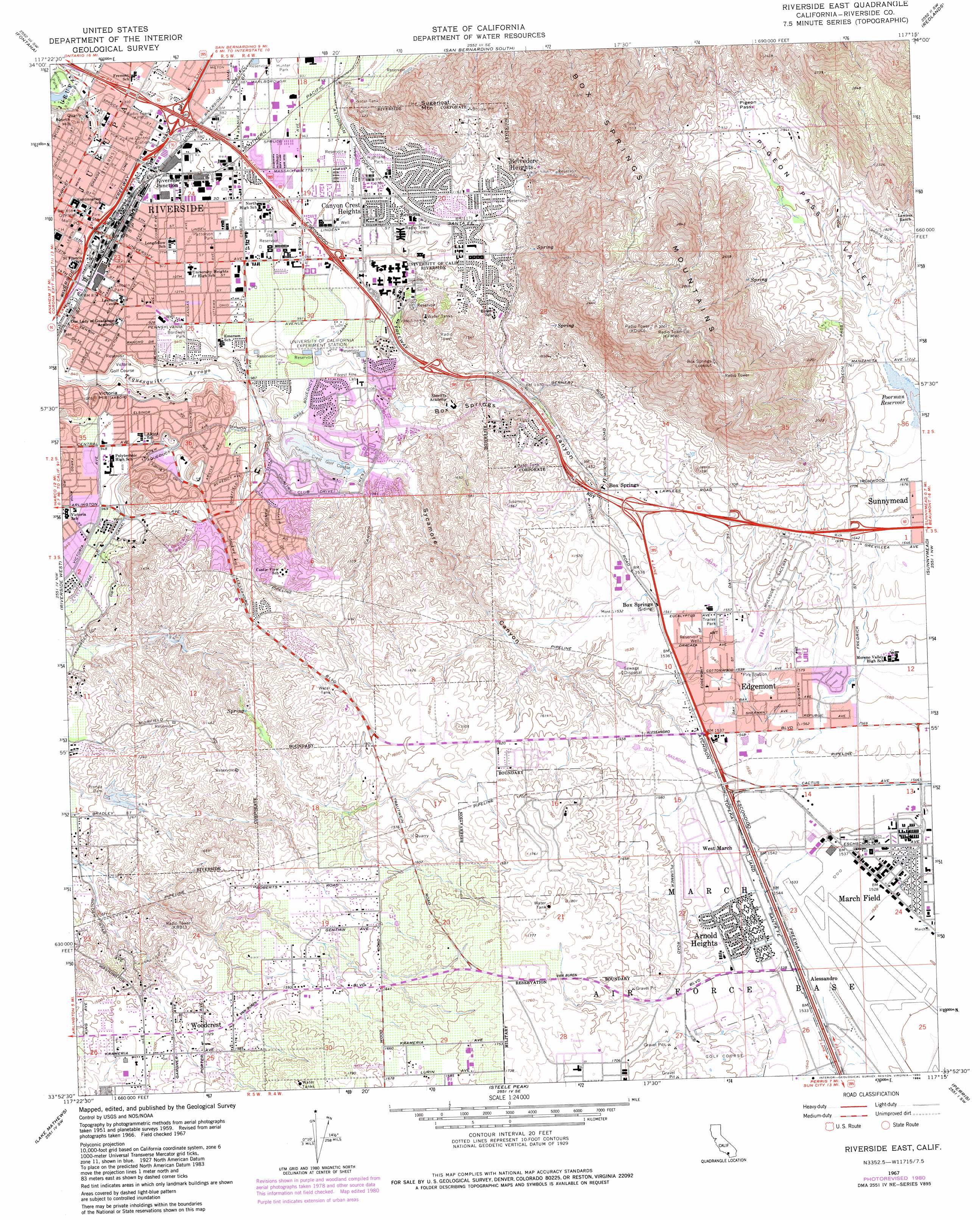
Riverside East Topo Map California
To zoom in, hover over the map of Riverside East
USGS Topo Quad 33117h3 - 1:24,000 scale
| Topo Map Name: | Riverside East |
| USGS Topo Quad ID: | 33117h3 |
| Print Size: | ca. 21 1/4" wide x 27" high |
| Southeast Coordinates: | 33.875° N latitude / 117.25° W longitude |
| Map Center Coordinates: | 33.9375° N latitude / 117.3125° W longitude |
| U.S. State: | CA |
| Filename: | o33117h3.jpg |
| Download Map JPG Image: | Riverside East topo map 1:24,000 scale |
| Map Type: | Topographic |
| Topo Series: | 7.5´ |
| Map Scale: | 1:24,000 |
| Source of Map Images: | United States Geological Survey (USGS) |
| Alternate Map Versions: |
Riverside East CA 1953, updated 1955 Download PDF Buy paper map Riverside East CA 1953, updated 1962 Download PDF Buy paper map Riverside East CA 1967, updated 1969 Download PDF Buy paper map Riverside East CA 1967, updated 1974 Download PDF Buy paper map Riverside East CA 1967, updated 1974 Download PDF Buy paper map Riverside East CA 1967, updated 1980 Download PDF Buy paper map Riverside East CA 1967, updated 1984 Download PDF Buy paper map Riverside East CA 1967, updated 1984 Download PDF Buy paper map Riverside East CA 2012 Download PDF Buy paper map Riverside East CA 2015 Download PDF Buy paper map |
1:24,000 Topo Quads surrounding Riverside East
Cucamonga Peak |
Devore |
San Bernardino North |
Harrison Mountain |
Keller Peak |
Guasti |
Fontana |
San Bernardino South |
Redlands |
Yucaipa |
Corona North |
Riverside West |
Riverside East |
Sunnymead |
El Casco |
Corona South |
Lake Mathews |
Steele Peak |
Perris |
Lakeview |
Santiago Peak |
Alberhill |
Lake Elsinore |
Romoland |
Winchester |
> Back to 33117e1 at 1:100,000 scale
> Back to 33116a1 at 1:250,000 scale
> Back to U.S. Topo Maps home
Riverside East topo map: Gazetteer
Riverside East: Canals
Gage Canal elevation 313m 1026′Riverside East: Crossings
Interchange 25 elevation 468m 1535′Interchange 27A elevation 472m 1548′
Interchange 27B elevation 471m 1545′
Interchange 27C elevation 465m 1525′
Interchange 28 elevation 471m 1545′
Interchange 29 elevation 470m 1541′
Interchange 30A elevation 457m 1499′
Interchange 30B elevation 421m 1381′
Interchange 31 elevation 370m 1213′
Interchange 32A elevation 318m 1043′
Interchange 32B elevation 315m 1033′
Interchange 33 elevation 293m 961′
Interchange 34A elevation 268m 879′
Interchange 34B elevation 269m 882′
Interchange 34C elevation 263m 862′
Riverside East: Dams
Alessandro 1003-003 Dam elevation 334m 1095′Box Springs 1003-007 Dam elevation 341m 1118′
Henry J Mills 35-014 Dam elevation 502m 1646′
Prenda 1003-004 Dam elevation 373m 1223′
Sycamore 1003-005 Dam elevation 310m 1017′
Riverside East: Gaps
Pigeon Pass elevation 586m 1922′Riverside East: Parks
Andulka Park elevation 311m 1020′Bergmont Park elevation 510m 1673′
Bobby Bonds Park and Sports Complex elevation 284m 931′
Bordwell Park elevation 284m 931′
Box Springs Mountain Regional Park elevation 598m 1961′
Castleview Park elevation 406m 1332′
Fairmount Park elevation 244m 800′
Hidden Springs Community Park elevation 538m 1765′
Hunter Park elevation 278m 912′
Islander Park elevation 360m 1181′
Lincoln Park elevation 271m 889′
Moreno Valley Community Park elevation 485m 1591′
Mount Vernon Park elevation 366m 1200′
North Park elevation 264m 866′
Orange Crest Number 2 Park elevation 542m 1778′
Patterson Park elevation 285m 935′
Quail Run Park elevation 419m 1374′
Sycamore Canyon Park elevation 403m 1322′
Taft Park elevation 495m 1624′
Towngate Memorial Park elevation 480m 1574′
Westbluff Park elevation 530m 1738′
Riverside East: Populated Places
Alessandro elevation 468m 1535′Arnold Heights elevation 475m 1558′
Bannockburn Village elevation 316m 1036′
Belvedere Heights elevation 377m 1236′
Box Springs elevation 459m 1505′
Canyon Crest Heights elevation 322m 1056′
Edgemont elevation 477m 1564′
Lemona elevation 330m 1082′
March Field elevation 466m 1528′
Riverside Junction elevation 269m 882′
West March elevation 472m 1548′
Woodcrest elevation 468m 1535′
Riverside East: Post Offices
March Air Reserve Base Post Office elevation 463m 1519′Riverside Post Offcie elevation 260m 853′
Riverside East: Ranges
Box Springs Mountains elevation 672m 2204′Riverside East: Springs
Cassina Springs elevation 708m 2322′Hidden Springs elevation 590m 1935′
Riverside East: Streams
Spring Brook elevation 245m 803′Riverside East: Summits
North Hill elevation 277m 908′Sugarloaf Mountain elevation 578m 1896′
Victoria Hill elevation 298m 977′
Riverside East: Valleys
Box Springs Canyon elevation 337m 1105′Pigeon Pass Valley elevation 517m 1696′
Sycamore Canyon elevation 317m 1040′
Riverside East digital topo map on disk
Buy this Riverside East topo map showing relief, roads, GPS coordinates and other geographical features, as a high-resolution digital map file on DVD: