Venice Topo Map California
To zoom in, hover over the map of Venice
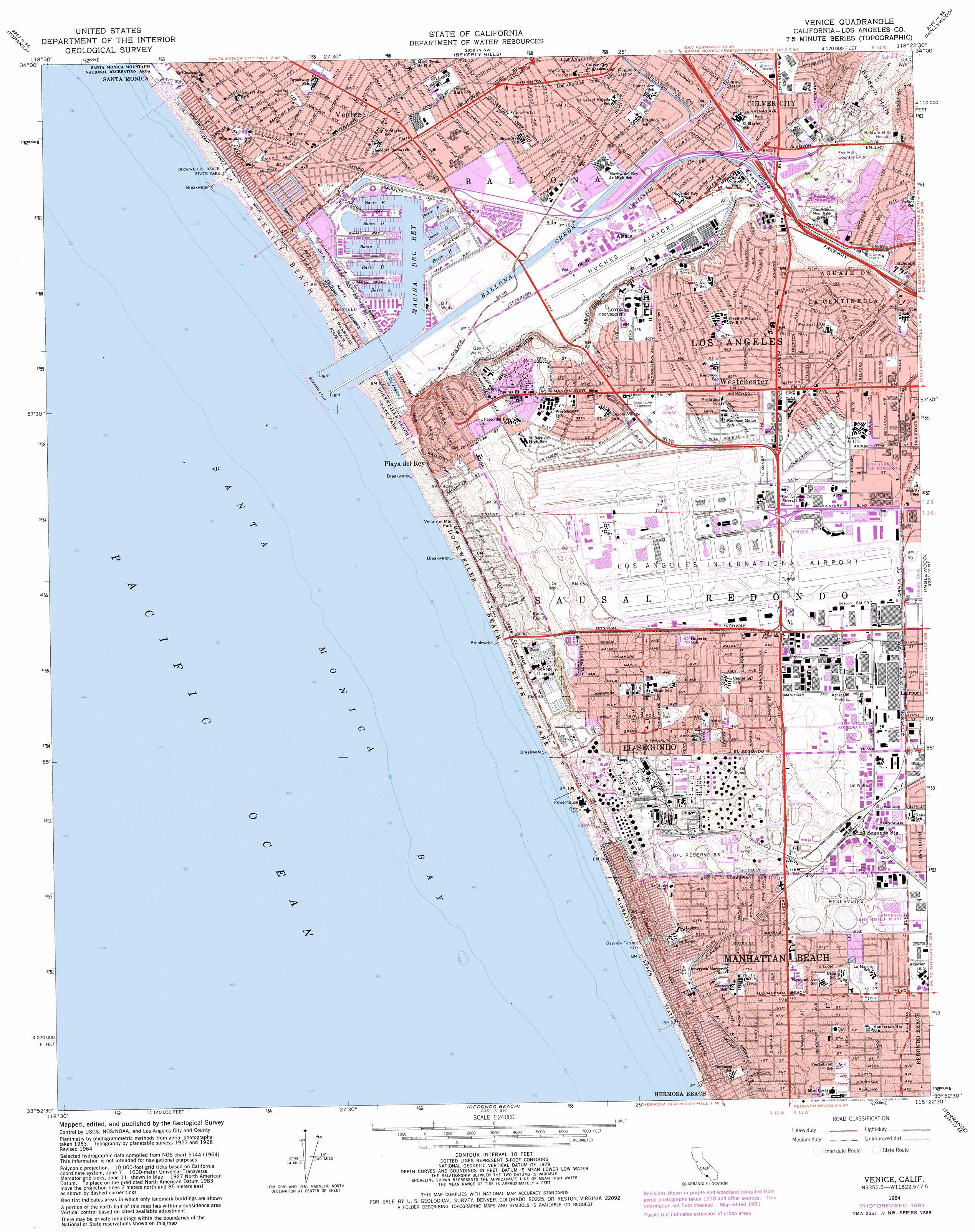
USGS Topo Quad 33118h4 - 1:24,000 scale
| Topo Map Name: | Venice |
| USGS Topo Quad ID: | 33118h4 |
| Print Size: | ca. 21 1/4" wide x 27" high |
| Southeast Coordinates: | 33.875° N latitude / 118.375° W longitude |
| Map Center Coordinates: | 33.9375° N latitude / 118.4375° W longitude |
| U.S. State: | CA |
| Filename: | o33118h4.jpg |
| Download Map JPG Image: | Venice topo map 1:24,000 scale |
| Map Type: | Topographic |
| Topo Series: | 7.5´ |
| Map Scale: | 1:24,000 |
| Source of Map Images: | United States Geological Survey (USGS) |
| Alternate Map Versions: |
Venice CA 1950, updated 1952 Download PDF Buy paper map Venice CA 1950, updated 1957 Download PDF Buy paper map Venice CA 1964, updated 1965 Download PDF Buy paper map Venice CA 1964, updated 1975 Download PDF Buy paper map Venice CA 1964, updated 1982 Download PDF Buy paper map Venice CA 1964, updated 1982 Download PDF Buy paper map Venice CA 2012 Download PDF Buy paper map Venice CA 2015 Download PDF Buy paper map |
1:24,000 Topo Quads surrounding Venice
Calabasas |
Canoga Park |
Van Nuys |
Burbank |
Pasadena |
Malibu |
Topanga |
Beverly Hills |
Hollywood |
Los Angeles |
Venice |
Inglewood |
South Gate |
||
Redondo Beach |
Torrance |
Long Beach |
||
San Pedro |
> Back to 33118e1 at 1:100,000 scale
> Back to 33118a1 at 1:250,000 scale
> Back to U.S. Topo Maps home
Venice topo map: Gazetteer
Venice: Airports
Airport Imperial Building Helistop elevation 41m 134′Airport Towers Number 1 Heliport elevation 35m 114′
Chevron Refinery Heliport elevation 2m 6′
Hughes Airport (historical) elevation 4m 13′
Hughes Corporate Heliport elevation 19m 62′
Hughes Space and Communications Heliport elevation 41m 134′
Kilroy Airport Center Heliport elevation 30m 98′
Los Angeles International Airport elevation 35m 114′
Merle Norman Cosmetics Building 3 Heliport elevation 31m 101′
Pacific Bell - 2300 Imperial Highway Heliport elevation 28m 91′
The Ritz-Carlton Hotel Company Heliport elevation 5m 16′
TRW-Manhattan Beach Heliport elevation 32m 104′
Venice: Areas
Airport Dunes elevation 22m 72′Venice: Bays
Santa Monica Bay elevation 13m 42′Venice: Beaches
Venice Beach elevation 1m 3′Venice: Canals
Centinela Creek Channel elevation 4m 13′Grand Canal elevation 2m 6′
Sepulveda Channel elevation 10m 32′
Venice: Crossings
Exit 1 elevation 36m 118′Exit 48 elevation 21m 68′
Exit 50A elevation 12m 39′
Exit 50B elevation 13m 42′
Venice: Harbors
Basin A elevation 0m 0′Basin B elevation 0m 0′
Basin C elevation 0m 0′
Basin D elevation 0m 0′
Basin E elevation 0m 0′
Basin F elevation 0m 0′
Basin G elevation 1m 3′
Basin H elevation 2m 6′
Marina del Rey elevation 0m 0′
Venice: Lakes
Ballona Lagoon elevation 4m 13′Del Rey Lagoon elevation 4m 13′
Venice: Parks
Acacia Park elevation 27m 88′Admiralty Park elevation 4m 13′
Aviation Park elevation 41m 134′
Blanco Park elevation 11m 36′
Burton Chace Park elevation 3m 9′
Candy Cane Park elevation 40m 131′
Carl E Nielsen Youth Park elevation 34m 111′
Constitution Park elevation 40m 131′
Culver Slauson Park elevation 8m 26′
Culver West Park elevation 10m 32′
Del Rey Lagoon Park elevation 6m 19′
Dockweiler State Beach elevation 5m 16′
El Marino Park elevation 8m 26′
Fox Hills Park elevation 31m 101′
Glen Alla Park elevation 6m 19′
Hannon Field elevation 46m 150′
Hilltop Park elevation 54m 177′
Holly Valley Park elevation 32m 104′
Kansas Park elevation 30m 98′
Kinney Plaza elevation 3m 9′
Leavey Field elevation 48m 157′
Library Park elevation 30m 98′
Live Oak Park elevation 39m 127′
Manhattan Beach State Park elevation 1m 3′
Manhattan Heights Park elevation 24m 78′
Mar Vista Gardens elevation 7m 22′
Marine Avenue Park elevation 30m 98′
Oakwood Playground elevation 7m 22′
Oakwood Recreation Center elevation 6m 19′
Page Baseball Stadium elevation 43m 141′
Parque Culiacan elevation 13m 42′
Polliwog Park elevation 26m 85′
Recreation Park elevation 25m 82′
Sand Dune Park elevation 27m 88′
Sullivan Field elevation 46m 150′
Sycamore Park elevation 34m 111′
Venice Canal Historic District elevation 1m 3′
Venice City Beach elevation 5m 16′
Venice Recreation Center elevation 4m 13′
Waller Football Stadium elevation 48m 157′
Washington Park elevation 38m 124′
Westchester Playground elevation 40m 131′
Westminster Park elevation 9m 29′
Venice: Populated Places
Alla elevation 5m 16′Alsace elevation 5m 16′
Culver Garden elevation 10m 32′
Cypress Grove elevation 9m 29′
Del Ray elevation 6m 19′
El Segundo elevation 35m 114′
Holton (historical) elevation 15m 49′
Hyperion (historical) elevation 10m 32′
Ladera Heights elevation 93m 305′
Lairport elevation 30m 98′
Machado (historical) elevation 4m 13′
Manhattan Beach elevation 20m 65′
Marina del Rey elevation 0m 0′
Motordrome (historical) elevation 2m 6′
Palisades Del Rey (historical) elevation 41m 134′
Playa del Rey elevation 6m 19′
Playa Vista elevation 2m 6′
Venice elevation 4m 13′
Westchester elevation 38m 124′
Venice: Post Offices
Culver City Post Office elevation 10m 32′El Segundo Post Office elevation 33m 108′
Fox Hills Station Culver City Post Office elevation 27m 88′
Manhattan Beach Post Office elevation 43m 141′
Ocean Park Station Santa Monica Post Office elevation 8m 26′
Venice: Streams
Ballona Creek elevation 0m 0′Venice: Swamps
Ballona Wetlands elevation 2m 6′Venice digital topo map on disk
Buy this Venice topo map showing relief, roads, GPS coordinates and other geographical features, as a high-resolution digital map file on DVD: