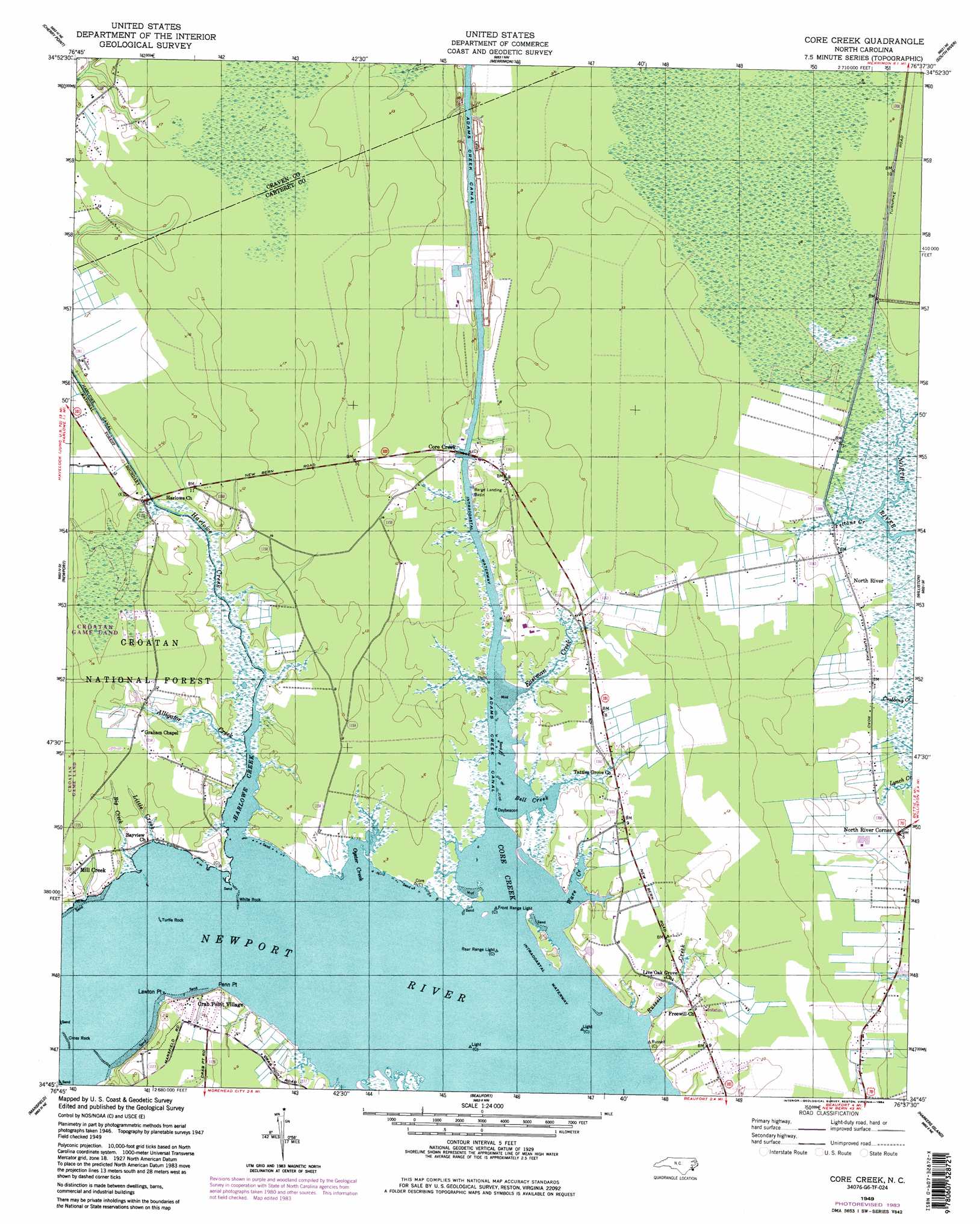
Core Creek Topo Map North Carolina
To zoom in, hover over the map of Core Creek
USGS Topo Quad 34076g6 - 1:24,000 scale
| Topo Map Name: | Core Creek |
| USGS Topo Quad ID: | 34076g6 |
| Print Size: | ca. 21 1/4" wide x 27" high |
| Southeast Coordinates: | 34.75° N latitude / 76.625° W longitude |
| Map Center Coordinates: | 34.8125° N latitude / 76.6875° W longitude |
| U.S. State: | NC |
| Filename: | o34076g6.jpg |
| Download Map JPG Image: | Core Creek topo map 1:24,000 scale |
| Map Type: | Topographic |
| Topo Series: | 7.5´ |
| Map Scale: | 1:24,000 |
| Source of Map Images: | United States Geological Survey (USGS) |
| Alternate Map Versions: |
Core Creek NC 1949, updated 1984 Download PDF Buy paper map Core Creek NC 1949, updated 1984 Download PDF Buy paper map Core Creek NC 1951 Download PDF Buy paper map Core Creek NC 1951, updated 1973 Download PDF Buy paper map Core Creek NC 1994, updated 1997 Download PDF Buy paper map Core Creek NC 1994, updated 1997 Download PDF Buy paper map Core Creek NC 2011 Download PDF Buy paper map Core Creek NC 2013 Download PDF Buy paper map Core Creek NC 2016 Download PDF Buy paper map |
| FStopo: | US Forest Service topo Core Creek is available: Download FStopo PDF Download FStopo TIF |
1:24,000 Topo Quads surrounding Core Creek
Upper Broad Creek |
Arapahoe |
Oriental |
Broad Creek |
Point Of Marsh |
Havelock |
Cherry Point |
Merrimon |
South River |
Long Bay |
Masontown |
Newport |
Core Creek |
Williston |
Davis |
Salter Path |
Mansfield |
Beaufort |
Harkers Island |
Horsepen Point |
Cape Lookout |
> Back to 34076e1 at 1:100,000 scale
> Back to 34076a1 at 1:250,000 scale
> Back to U.S. Topo Maps home
Core Creek topo map: Gazetteer
Core Creek: Bars
Cross Rock elevation 0m 0′Turtle Rock elevation 0m 0′
White Rock elevation 0m 0′
Core Creek: Bays
Bell Creek elevation 0m 0′Core Creek elevation 0m 0′
Oyster Creek elevation 0m 0′
Ware Creek elevation 0m 0′
Core Creek: Beaches
Deer Field Shores elevation 1m 3′Core Creek: Canals
Adams Creek Canal elevation 0m 0′Harlowe Canal elevation 3m 9′
Core Creek: Capes
Lawton Point elevation 1m 3′Penn Point elevation 0m 0′
Core Creek: Populated Places
Cedarville Estates elevation 3m 9′Core Creek elevation 1m 3′
Crab Point Village elevation 4m 13′
Craven Corner elevation 3m 9′
Joslyn Trace elevation 2m 6′
McDaniels elevation 3m 9′
Mill Creek elevation 3m 9′
North Harbor elevation 1m 3′
North River elevation 1m 3′
North River Corner elevation 1m 3′
River Heights elevation 2m 6′
Seagate elevation 3m 9′
Core Creek: Streams
Alligator Creek elevation 1m 3′Big Creek elevation 3m 9′
Eastman Creek elevation 0m 0′
Feltons Creek elevation 1m 3′
Harlowe Creek elevation 0m 0′
Little Creek elevation 2m 6′
Russell Creek elevation 0m 0′
Core Creek digital topo map on disk
Buy this Core Creek topo map showing relief, roads, GPS coordinates and other geographical features, as a high-resolution digital map file on DVD:
Atlantic Coast (NY, NJ, PA, DE, MD, VA, NC)
Buy digital topo maps: Atlantic Coast (NY, NJ, PA, DE, MD, VA, NC)
 map DVD")