Newport Topo Map North Carolina
To zoom in, hover over the map of Newport
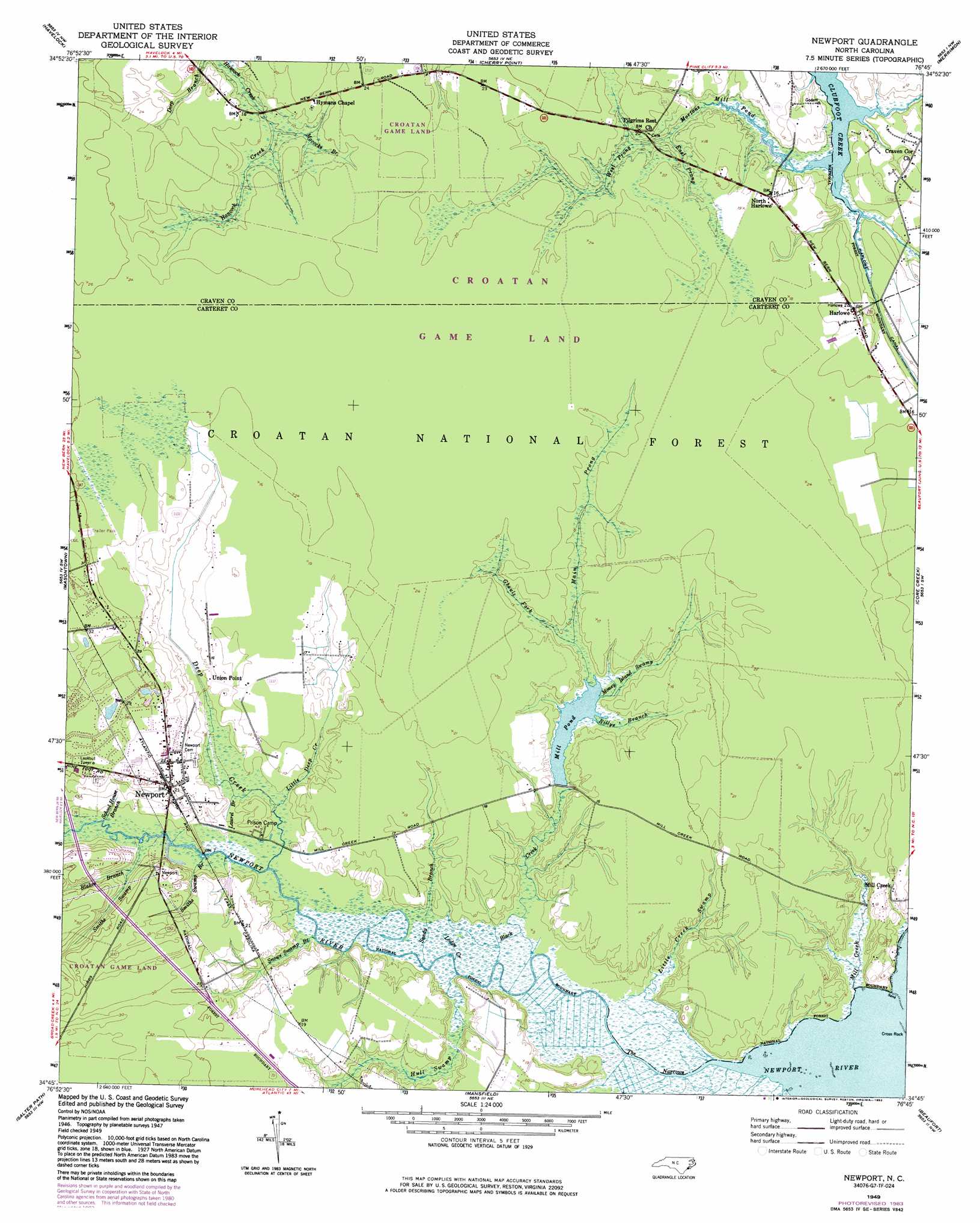
USGS Topo Quad 34076g7 - 1:24,000 scale
| Topo Map Name: | Newport |
| USGS Topo Quad ID: | 34076g7 |
| Print Size: | ca. 21 1/4" wide x 27" high |
| Southeast Coordinates: | 34.75° N latitude / 76.75° W longitude |
| Map Center Coordinates: | 34.8125° N latitude / 76.8125° W longitude |
| U.S. State: | NC |
| Filename: | o34076g7.jpg |
| Download Map JPG Image: | Newport topo map 1:24,000 scale |
| Map Type: | Topographic |
| Topo Series: | 7.5´ |
| Map Scale: | 1:24,000 |
| Source of Map Images: | United States Geological Survey (USGS) |
| Alternate Map Versions: |
Newport NC 1949, updated 1983 Download PDF Buy paper map Newport NC 1951 Download PDF Buy paper map Newport NC 1951, updated 1973 Download PDF Buy paper map Newport NC 1951, updated 1978 Download PDF Buy paper map Newport NC 1994, updated 1997 Download PDF Buy paper map Newport NC 2011 Download PDF Buy paper map Newport NC 2013 Download PDF Buy paper map Newport NC 2016 Download PDF Buy paper map |
| FStopo: | US Forest Service topo Newport is available: Download FStopo PDF Download FStopo TIF |
1:24,000 Topo Quads surrounding Newport
New Bern |
Upper Broad Creek |
Arapahoe |
Oriental |
Broad Creek |
Catfish Lake |
Havelock |
Cherry Point |
Merrimon |
South River |
Hadnot Creek |
Masontown |
Newport |
Core Creek |
Williston |
Swansboro |
Salter Path |
Mansfield |
Beaufort |
Harkers Island |
Cape Lookout |
> Back to 34076e1 at 1:100,000 scale
> Back to 34076a1 at 1:250,000 scale
> Back to U.S. Topo Maps home
Newport topo map: Gazetteer
Newport: Channels
The Narrows elevation 1m 3′Newport: Parks
Dickson Park elevation 6m 19′Newport River Park elevation 1m 3′
Newport: Populated Places
Docs Mobile Home Park elevation 8m 26′Harlowe elevation 4m 13′
Newport elevation 6m 19′
North Harlowe elevation 4m 13′
Union Point elevation 4m 13′
Newport: Reservoirs
Mill Pond elevation 3m 9′Newport: Streams
Billys Branch elevation 2m 6′Black Creek elevation 0m 0′
Blakes Branch elevation 0m 0′
Deep Creek elevation 0m 0′
East Prong Mortons Mill Pond elevation 1m 3′
Ghouls Fork elevation 2m 6′
Hull Swamp elevation 0m 0′
Laurel Branch elevation 0m 0′
Little Creek Swamp elevation 0m 0′
Little Deep Creek elevation 0m 0′
Lodge Creek elevation 0m 0′
Main Prong elevation 2m 6′
Mill Creek elevation 1m 3′
Mococks Branch elevation 1m 3′
Money Island Swamp elevation 1m 3′
Mortons Mill Pond elevation 5m 16′
Sandy Branch elevation 1m 3′
School House Branch elevation 0m 0′
Smiths Swamp elevation 0m 0′
Smiths Swamp Branch elevation 0m 0′
Snows Swamp Branch elevation 0m 0′
West Prong Mortons Mill Pond elevation 1m 3′
Newport: Trails
Neusiok Trail elevation 7m 22′Newport digital topo map on disk
Buy this Newport topo map showing relief, roads, GPS coordinates and other geographical features, as a high-resolution digital map file on DVD:
Atlantic Coast (NY, NJ, PA, DE, MD, VA, NC)
Buy digital topo maps: Atlantic Coast (NY, NJ, PA, DE, MD, VA, NC)
 map DVD")