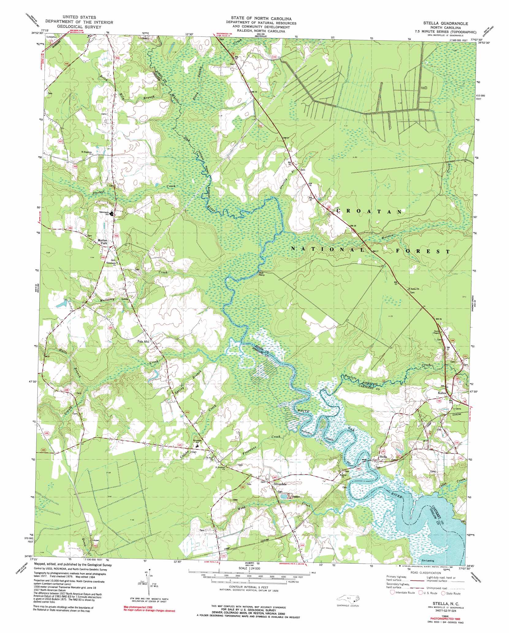
Stella Topo Map North Carolina
To zoom in, hover over the map of Stella
USGS Topo Quad 34077g2 - 1:24,000 scale
| Topo Map Name: | Stella |
| USGS Topo Quad ID: | 34077g2 |
| Print Size: | ca. 21 1/4" wide x 27" high |
| Southeast Coordinates: | 34.75° N latitude / 77.125° W longitude |
| Map Center Coordinates: | 34.8125° N latitude / 77.1875° W longitude |
| U.S. State: | NC |
| Filename: | o34077g2.jpg |
| Download Map JPG Image: | Stella topo map 1:24,000 scale |
| Map Type: | Topographic |
| Topo Series: | 7.5´ |
| Map Scale: | 1:24,000 |
| Source of Map Images: | United States Geological Survey (USGS) |
| Alternate Map Versions: |
Stella NC 1984, updated 1984 Download PDF Buy paper map Stella NC 1984, updated 1991 Download PDF Buy paper map Stella NC 1994, updated 1997 Download PDF Buy paper map Stella NC 1994, updated 1997 Download PDF Buy paper map Stella NC 2011 Download PDF Buy paper map Stella NC 2013 Download PDF Buy paper map Stella NC 2016 Download PDF Buy paper map |
| FStopo: | US Forest Service topo Stella is available: Download FStopo PDF Download FStopo TIF |
1:24,000 Topo Quads surrounding Stella
Phillips Crossroads |
Trenton |
Pollocksville |
New Bern |
Upper Broad Creek |
Jacksonville Nw |
Jacksonville Ne |
Maysville |
Catfish Lake |
Havelock |
Jacksonville North |
Kellum |
Stella |
Hadnot Creek |
Masontown |
Jacksonville South |
Camp Lejeune |
Hubert |
Swansboro |
Salter Path |
Sneads Ferry |
New River Inlet |
Browns Inlet |
> Back to 34077e1 at 1:100,000 scale
> Back to 34076a1 at 1:250,000 scale
> Back to U.S. Topo Maps home
Stella topo map: Gazetteer
Stella: Bridges
Stella Bridge elevation -1m -4′Stella: Parks
Haywood Landing Recreation Site elevation 5m 16′Stella: Populated Places
Bryans Mobile Home Park elevation 11m 36′Kuhns elevation 7m 22′
Morton Fork elevation 12m 39′
Pala Alto elevation 8m 26′
Silverdale elevation 7m 22′
Stella elevation 2m 6′
Stella: Post Offices
Fowle Post Office (historical) elevation 8m 26′Stella: Streams
Black Swamp Creek elevation 5m 16′Brick Kiln Branch elevation 0m 0′
Calebs Creek elevation 0m 0′
Cales Creek elevation 0m 0′
Freemans Creek elevation 0m 0′
Grants Creek elevation 1m 3′
Gravelly Branch elevation 0m 0′
Halls Branch elevation 2m 6′
Holston Creek elevation 0m 0′
Hunters Creek elevation -1m -4′
Mulberry Creek elevation 0m 0′
Spring Branch elevation 0m 0′
Starkys Creek elevation 0m 0′
Webb Creek elevation 0m 0′
Stella digital topo map on disk
Buy this Stella topo map showing relief, roads, GPS coordinates and other geographical features, as a high-resolution digital map file on DVD:
Atlantic Coast (NY, NJ, PA, DE, MD, VA, NC)
Buy digital topo maps: Atlantic Coast (NY, NJ, PA, DE, MD, VA, NC)
 map DVD")