Lewis Swamp Topo Map North Carolina
To zoom in, hover over the map of Lewis Swamp
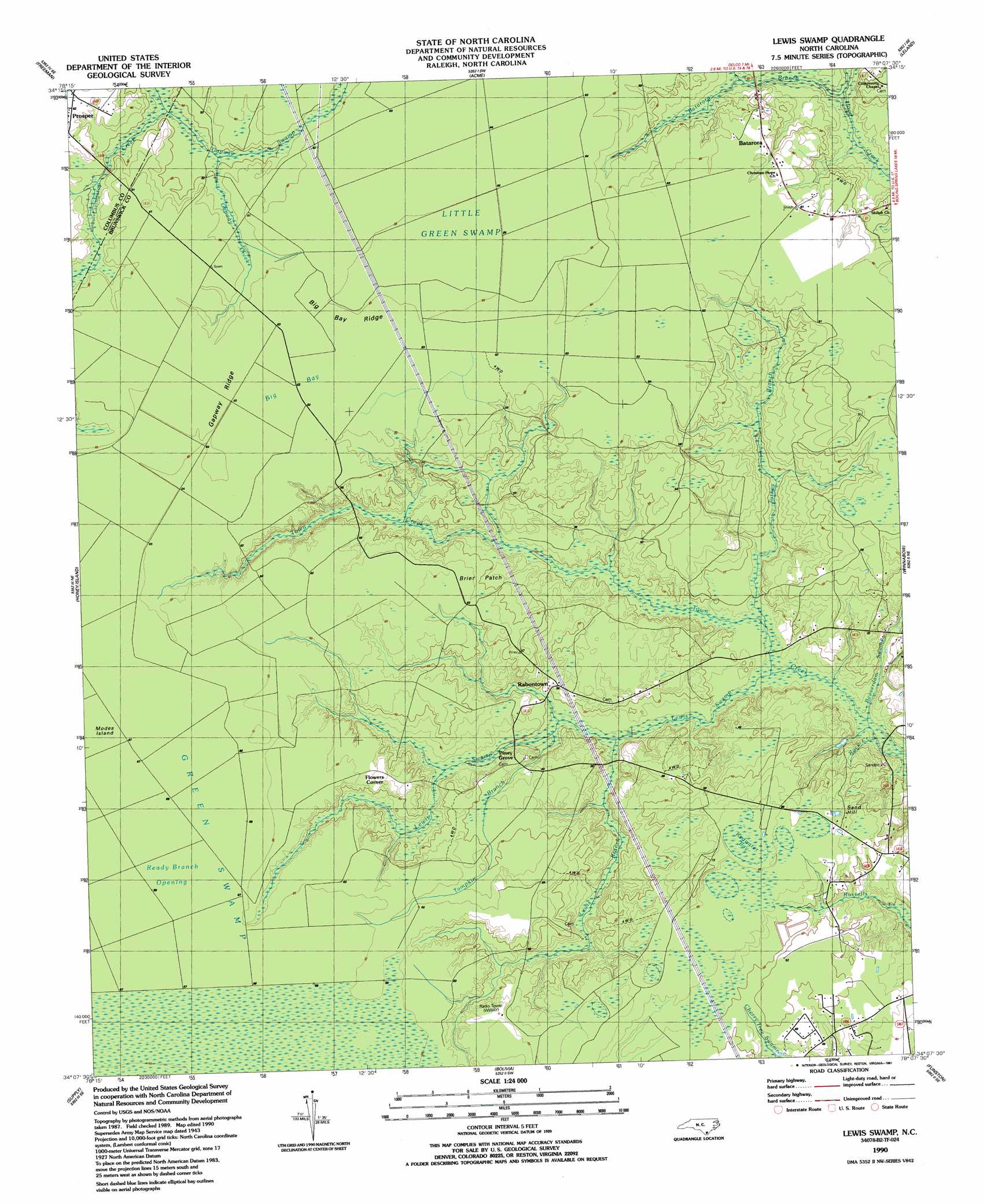
USGS Topo Quad 34078b2 - 1:24,000 scale
| Topo Map Name: | Lewis Swamp |
| USGS Topo Quad ID: | 34078b2 |
| Print Size: | ca. 21 1/4" wide x 27" high |
| Southeast Coordinates: | 34.125° N latitude / 78.125° W longitude |
| Map Center Coordinates: | 34.1875° N latitude / 78.1875° W longitude |
| U.S. State: | NC |
| Filename: | o34078b2.jpg |
| Download Map JPG Image: | Lewis Swamp topo map 1:24,000 scale |
| Map Type: | Topographic |
| Topo Series: | 7.5´ |
| Map Scale: | 1:24,000 |
| Source of Map Images: | United States Geological Survey (USGS) |
| Alternate Map Versions: |
Lewis Swamp NC 1943, updated 1962 Download PDF Buy paper map Lewis Swamp NC 1980, updated 1985 Download PDF Buy paper map Lewis Swamp NC 1990, updated 1991 Download PDF Buy paper map Lewis Swamp NC 2010 Download PDF Buy paper map Lewis Swamp NC 2013 Download PDF Buy paper map Lewis Swamp NC 2016 Download PDF Buy paper map |
1:24,000 Topo Quads surrounding Lewis Swamp
Council |
Kelly |
Point Caswell |
Currie |
Rocky Point |
Lake Waccamaw East |
Freeman |
Acme |
Leland |
Castle Hayne |
Juniper Creek |
Honey Island |
Lewis Swamp |
Winnabow |
Wilmington |
Exum |
Supply |
Bolivia |
Funston |
Carolina Beach |
Shallotte |
Holden Beach |
Lockwoods Folly |
Southport |
Kure Beach |
> Back to 34078a1 at 1:100,000 scale
> Back to 34078a1 at 1:250,000 scale
> Back to U.S. Topo Maps home
Lewis Swamp topo map: Gazetteer
Lewis Swamp: Flats
Brier Patch elevation 18m 59′Lewis Swamp: Islands
Modes Island elevation 20m 65′Lewis Swamp: Populated Places
Batarora elevation 18m 59′Flowers Corner elevation 18m 59′
Old Cumbee Place elevation 19m 62′
Rabontown elevation 12m 39′
Lewis Swamp: Ridges
Big Bay Ridge elevation 19m 62′Gapway Ridge elevation 19m 62′
Lewis Swamp: Streams
Batarora Branch elevation 9m 29′Beaverdam Swamp elevation 2m 6′
Gapway Creek elevation 14m 45′
Gapway Swamp elevation 12m 39′
Lewis Branch elevation 5m 16′
Lewis Swamp elevation 3m 9′
Rock Creek elevation 2m 6′
Tompkin Branch elevation 6m 19′
Turkey Branch elevation 4m 13′
Lewis Swamp: Summits
Sand Hill elevation 17m 55′Lewis Swamp: Swamps
Big Bay elevation 19m 62′Little Green Swamp elevation 19m 62′
Ready Branch Opening elevation 20m 65′
Redwater Bay elevation 21m 68′
Lewis Swamp digital topo map on disk
Buy this Lewis Swamp topo map showing relief, roads, GPS coordinates and other geographical features, as a high-resolution digital map file on DVD:
South Carolina, Western North Carolina & Northeastern Georgia
Buy digital topo maps: South Carolina, Western North Carolina & Northeastern Georgia