Cerro Gordo Topo Map North Carolina
To zoom in, hover over the map of Cerro Gordo
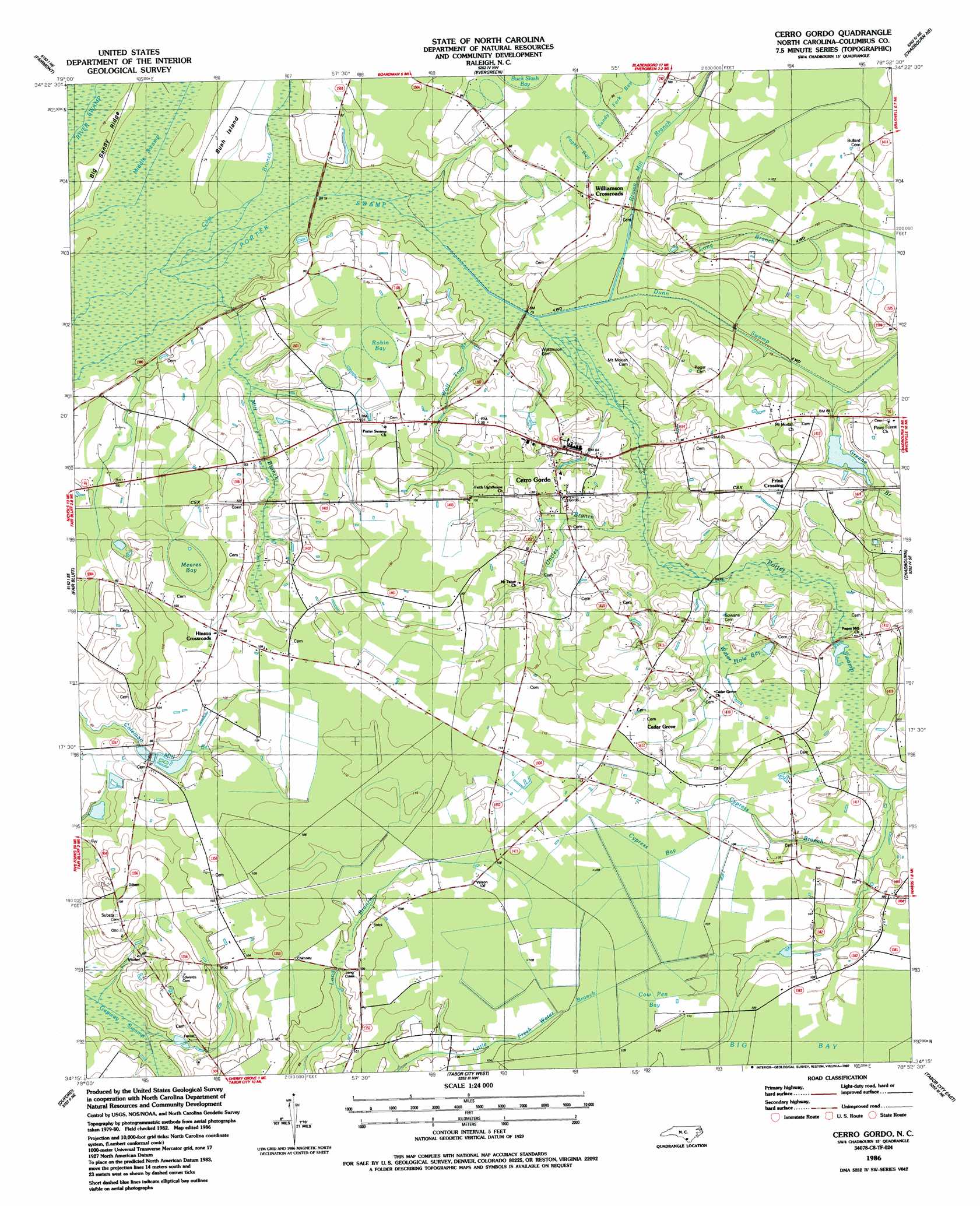
USGS Topo Quad 34078c8 - 1:24,000 scale
| Topo Map Name: | Cerro Gordo |
| USGS Topo Quad ID: | 34078c8 |
| Print Size: | ca. 21 1/4" wide x 27" high |
| Southeast Coordinates: | 34.25° N latitude / 78.875° W longitude |
| Map Center Coordinates: | 34.3125° N latitude / 78.9375° W longitude |
| U.S. State: | NC |
| Filename: | o34078c8.jpg |
| Download Map JPG Image: | Cerro Gordo topo map 1:24,000 scale |
| Map Type: | Topographic |
| Topo Series: | 7.5´ |
| Map Scale: | 1:24,000 |
| Source of Map Images: | United States Geological Survey (USGS) |
| Alternate Map Versions: |
Cerro Gordo NC 1986, updated 1987 Download PDF Buy paper map Cerro Gordo NC 2010 Download PDF Buy paper map Cerro Gordo NC 2013 Download PDF Buy paper map Cerro Gordo NC 2016 Download PDF Buy paper map |
1:24,000 Topo Quads surrounding Cerro Gordo
Mcdonald |
Southwest Lumberton |
Southeast Lumberton |
Bladenboro |
Abbottsburg |
Gaddysville |
Fairmont |
Evergreen |
Chadbourn Ne |
Clarkton |
Lake View |
Fair Bluff |
Cerro Gordo |
Chadbourn |
Whiteville |
Nichols |
Duford |
Tabor City West |
Tabor City East |
Nakina |
Galivants Ferry |
Bayboro |
Loris |
Goretown |
Pireway |
> Back to 34078a1 at 1:100,000 scale
> Back to 34078a1 at 1:250,000 scale
> Back to U.S. Topo Maps home
Cerro Gordo topo map: Gazetteer
Cerro Gordo: Capes
Bush Island elevation 21m 68′Cerro Gordo: Dams
Annetts Pond Dam elevation 29m 95′Cerro Gordo: Guts
Long Branch elevation 30m 98′Cerro Gordo: Populated Places
Cedar Grove elevation 33m 108′Cerro Gordo elevation 27m 88′
Frink Crossing elevation 32m 104′
Hinson Crossroads elevation 32m 104′
Williamson Crossroads elevation 29m 95′
Cerro Gordo: Reservoirs
Annetts Pond elevation 29m 95′Mill Pond elevation 21m 68′
Cerro Gordo: Streams
Brown Mill Branch elevation 22m 72′Cerro Gordo elevation 23m 75′
Cow Branch elevation 21m 68′
Cypress Branch elevation 28m 91′
Dunn Swamp elevation 23m 75′
Greene Branch elevation 26m 85′
Mill Branch elevation 21m 68′
Uncles Branch elevation 23m 75′
Water Branch elevation 27m 88′
Wolf Trap Branch elevation 22m 72′
Cerro Gordo: Swamps
Cedar Grove elevation 30m 98′Cow Pen Bay (historical) elevation 32m 104′
Cypress Bay (historical) elevation 33m 108′
Meares Bay elevation 29m 95′
Middle Swamp elevation 21m 68′
Pagett Bay elevation 29m 95′
Porter Swamp elevation 21m 68′
Robin Bay elevation 27m 88′
Sandy Fork Bay elevation 30m 98′
Water Hole Bay elevation 27m 88′
Cerro Gordo digital topo map on disk
Buy this Cerro Gordo topo map showing relief, roads, GPS coordinates and other geographical features, as a high-resolution digital map file on DVD:
South Carolina, Western North Carolina & Northeastern Georgia
Buy digital topo maps: South Carolina, Western North Carolina & Northeastern Georgia