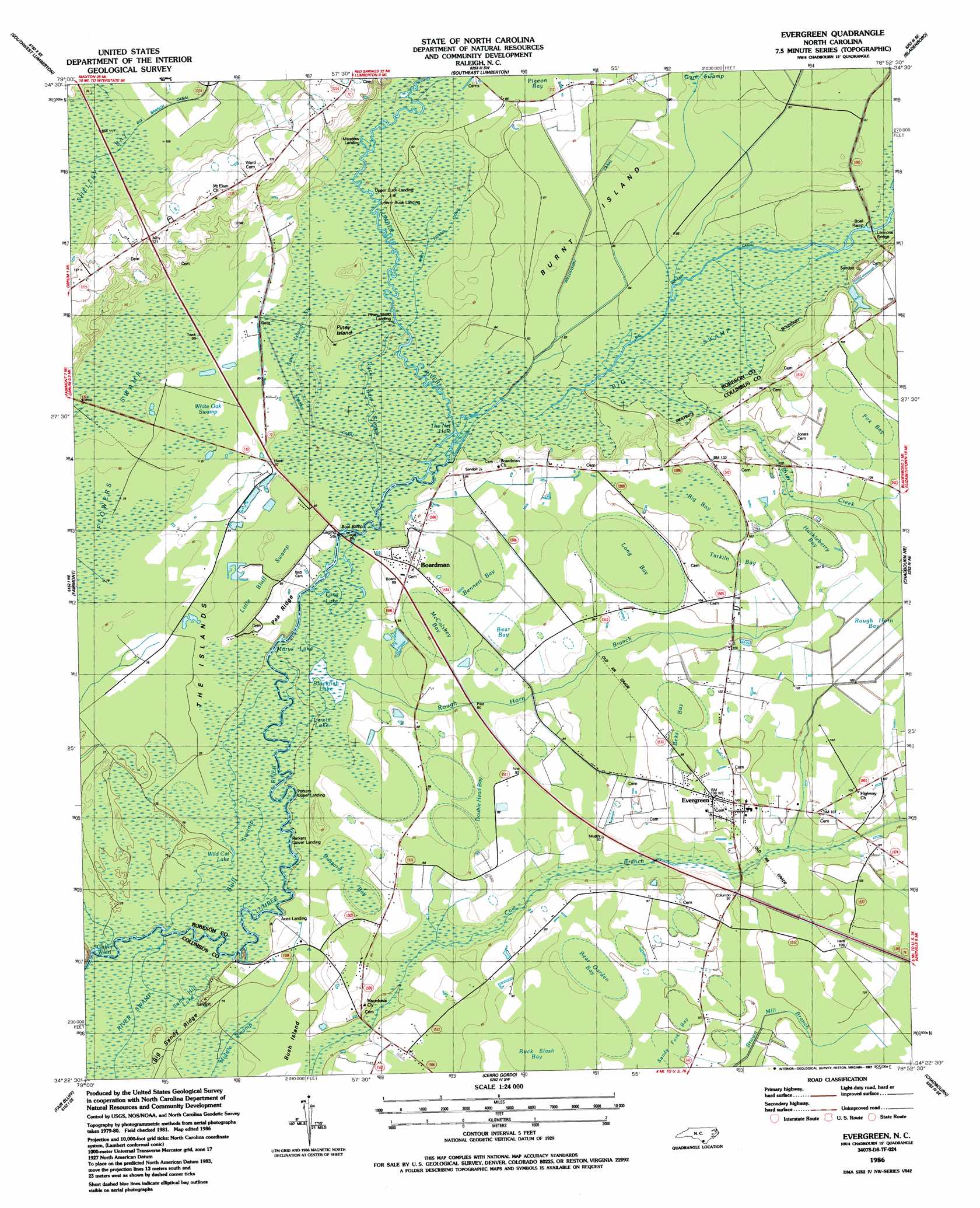
Evergreen Topo Map North Carolina
To zoom in, hover over the map of Evergreen
USGS Topo Quad 34078d8 - 1:24,000 scale
| Topo Map Name: | Evergreen |
| USGS Topo Quad ID: | 34078d8 |
| Print Size: | ca. 21 1/4" wide x 27" high |
| Southeast Coordinates: | 34.375° N latitude / 78.875° W longitude |
| Map Center Coordinates: | 34.4375° N latitude / 78.9375° W longitude |
| U.S. State: | NC |
| Filename: | o34078d8.jpg |
| Download Map JPG Image: | Evergreen topo map 1:24,000 scale |
| Map Type: | Topographic |
| Topo Series: | 7.5´ |
| Map Scale: | 1:24,000 |
| Source of Map Images: | United States Geological Survey (USGS) |
| Alternate Map Versions: |
Evergreen NC 1986, updated 1987 Download PDF Buy paper map Evergreen NC 2010 Download PDF Buy paper map Evergreen NC 2013 Download PDF Buy paper map Evergreen NC 2016 Download PDF Buy paper map |
1:24,000 Topo Quads surrounding Evergreen
Pembroke |
Northwest Lumberton |
Northeast Lumberton |
Tar Heel |
Dublin |
Mcdonald |
Southwest Lumberton |
Southeast Lumberton |
Bladenboro |
Abbottsburg |
Gaddysville |
Fairmont |
Evergreen |
Chadbourn Ne |
Clarkton |
Lake View |
Fair Bluff |
Cerro Gordo |
Chadbourn |
Whiteville |
Nichols |
Duford |
Tabor City West |
Tabor City East |
Nakina |
> Back to 34078a1 at 1:100,000 scale
> Back to 34078a1 at 1:250,000 scale
> Back to U.S. Topo Maps home
Evergreen topo map: Gazetteer
Evergreen: Bays
Griffin Whirl elevation 21m 68′Evergreen: Bridges
Iveys Bridge elevation 24m 78′Lennons Bridge elevation 25m 82′
Evergreen: Canals
Big Swamp Canal elevation 25m 82′Gum Swamp Canal elevation 26m 85′
Piney Island Canal elevation 25m 82′
Stevens Canal elevation 25m 82′
Willoughby Canal elevation 26m 85′
Evergreen: Flats
The Islands elevation 24m 78′Evergreen: Guts
Duck Bait Slough elevation 24m 78′Sand Island Slough elevation 25m 82′
Evergreen: Islands
Piney Island elevation 25m 82′Evergreen: Lakes
Blackfish Lake (historical) elevation 23m 75′Lewis Lake (historical) elevation 23m 75′
Long Lake elevation 23m 75′
Marys Lake elevation 23m 75′
Sand Hill Lake elevation 22m 72′
Smith Lake elevation 23m 75′
The Net Hole elevation 24m 78′
Wild Cat Lake elevation 23m 75′
Evergreen: Populated Places
Boardman elevation 27m 88′Evergreen elevation 31m 101′
Evergreen: Ridges
Pea Ridge elevation 28m 91′Evergreen: Streams
Big Swamp elevation 24m 78′Brier Creek elevation 25m 82′
Rough Horn Branch elevation 23m 75′
Evergreen: Swamps
Bear Bay elevation 27m 88′Bear Garden Bay elevation 29m 95′
Beks Bay elevation 30m 98′
Bennett Bay elevation 26m 85′
Big Bay elevation 30m 98′
Blackfish Lake elevation 23m 75′
Bluff Swamp elevation 22m 72′
Buck Slash Bay elevation 28m 91′
Buzzard Bay elevation 25m 82′
Double Head Bay elevation 27m 88′
Fox Bay elevation 33m 108′
Huckleberry Bay elevation 31m 101′
Lewis Lake elevation 23m 75′
Little Bluff Swamp elevation 24m 78′
Log Pine Bay elevation 28m 91′
Long Bay elevation 28m 91′
McColskey Bay elevation 26m 85′
Scoggin Bay elevation 29m 95′
Tarkiln Bay elevation 31m 101′
White Oak Swamp elevation 24m 78′
Evergreen digital topo map on disk
Buy this Evergreen topo map showing relief, roads, GPS coordinates and other geographical features, as a high-resolution digital map file on DVD:
South Carolina, Western North Carolina & Northeastern Georgia
Buy digital topo maps: South Carolina, Western North Carolina & Northeastern Georgia