Saint Pauls Topo Map North Carolina
To zoom in, hover over the map of Saint Pauls
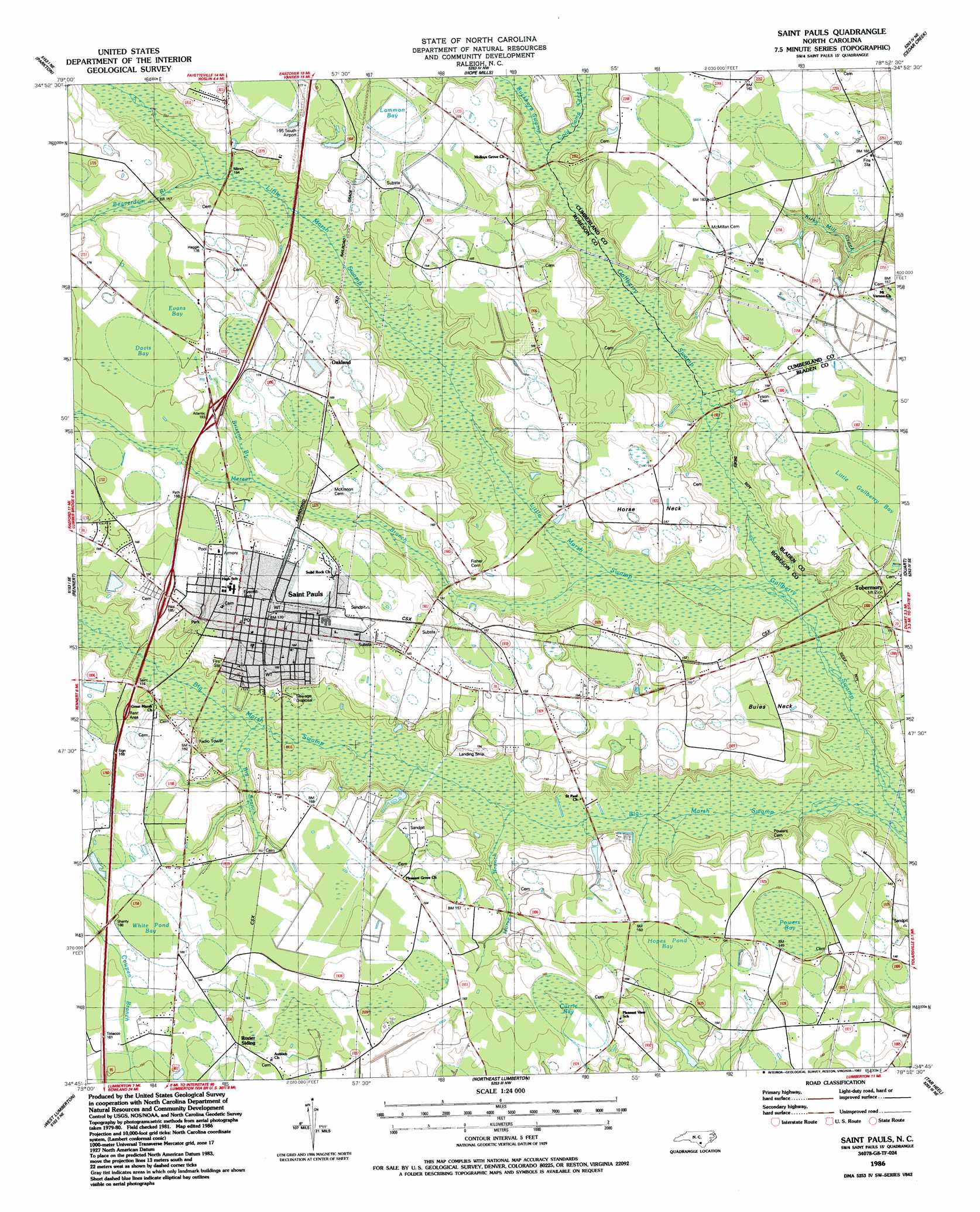
USGS Topo Quad 34078g8 - 1:24,000 scale
| Topo Map Name: | Saint Pauls |
| USGS Topo Quad ID: | 34078g8 |
| Print Size: | ca. 21 1/4" wide x 27" high |
| Southeast Coordinates: | 34.75° N latitude / 78.875° W longitude |
| Map Center Coordinates: | 34.8125° N latitude / 78.9375° W longitude |
| U.S. State: | NC |
| Filename: | o34078g8.jpg |
| Download Map JPG Image: | Saint Pauls topo map 1:24,000 scale |
| Map Type: | Topographic |
| Topo Series: | 7.5´ |
| Map Scale: | 1:24,000 |
| Source of Map Images: | United States Geological Survey (USGS) |
| Alternate Map Versions: |
Saint Pauls NC 1986, updated 1987 Download PDF Buy paper map Saint Pauls NC 1997, updated 2000 Download PDF Buy paper map Saint Pauls NC 2010 Download PDF Buy paper map Saint Pauls NC 2013 Download PDF Buy paper map Saint Pauls NC 2016 Download PDF Buy paper map |
1:24,000 Topo Quads surrounding Saint Pauls
Nicholson Creek |
Clifdale |
Fayetteville |
Vander |
Stedman |
Raeford |
Parkton |
Hope Mills |
Cedar Creek |
Autryville |
Red Springs |
Rennert |
Saint Pauls |
Duart |
Jerome |
Pembroke |
Northwest Lumberton |
Northeast Lumberton |
Tar Heel |
Dublin |
Mcdonald |
Southwest Lumberton |
Southeast Lumberton |
Bladenboro |
Abbottsburg |
> Back to 34078e1 at 1:100,000 scale
> Back to 34078a1 at 1:250,000 scale
> Back to U.S. Topo Maps home
Saint Pauls topo map: Gazetteer
Saint Pauls: Airports
I-95 South Airport elevation 50m 164′Saint Pauls: Basins
Currie Bay elevation 48m 157′Davis Bay elevation 52m 170′
Evans Bay elevation 53m 173′
Hopes Pond Bay elevation 46m 150′
Lammon Bay elevation 49m 160′
Little Gallberry Bay elevation 46m 150′
Powers Bay elevation 45m 147′
White Pond Bay elevation 50m 164′
Saint Pauls: Capes
Buies Neck elevation 42m 137′Horse Neck elevation 46m 150′
Saint Pauls: Parks
Everett Park elevation 52m 170′Saint Pauls: Populated Places
Buies Neck elevation 42m 137′Deerfield Farm Mobile Home Park elevation 49m 160′
Horse Neck elevation 45m 147′
Oakland elevation 53m 173′
Rozier Siding elevation 48m 157′
Saint Pauls elevation 51m 167′
Tobermory elevation 46m 150′
Saint Pauls: Reservoirs
Odom Pond elevation 44m 144′Saint Pauls: Streams
Beaverdam Branch elevation 45m 147′Big Branch elevation 43m 141′
Brisson Branch elevation 48m 157′
Buckhorn Swamp elevation 43m 141′
Cold Camp Creek elevation 43m 141′
Horse Branch elevation 40m 131′
Little Marsh Swamp elevation 38m 124′
Mercer Branch elevation 39m 127′
Saint Pauls digital topo map on disk
Buy this Saint Pauls topo map showing relief, roads, GPS coordinates and other geographical features, as a high-resolution digital map file on DVD:
South Carolina, Western North Carolina & Northeastern Georgia
Buy digital topo maps: South Carolina, Western North Carolina & Northeastern Georgia