Bayboro Topo Map South Carolina
To zoom in, hover over the map of Bayboro
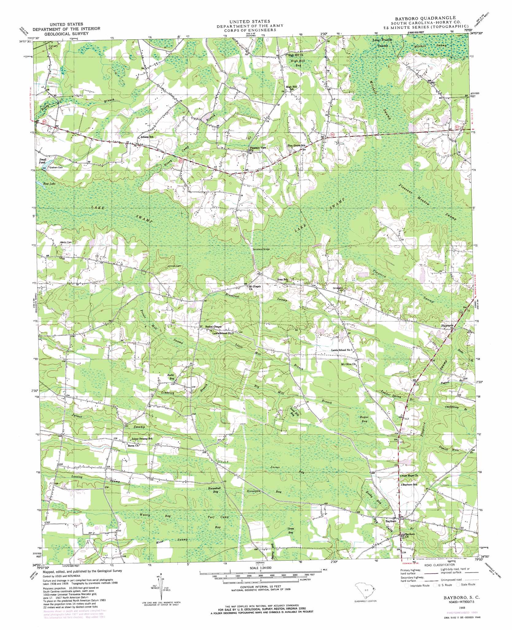
USGS Topo Quad 34079a1 - 1:24,000 scale
| Topo Map Name: | Bayboro |
| USGS Topo Quad ID: | 34079a1 |
| Print Size: | ca. 21 1/4" wide x 27" high |
| Southeast Coordinates: | 34° N latitude / 79° W longitude |
| Map Center Coordinates: | 34.0625° N latitude / 79.0625° W longitude |
| U.S. State: | SC |
| Filename: | o34079a1.jpg |
| Download Map JPG Image: | Bayboro topo map 1:24,000 scale |
| Map Type: | Topographic |
| Topo Series: | 7.5´ |
| Map Scale: | 1:24,000 |
| Source of Map Images: | United States Geological Survey (USGS) |
| Alternate Map Versions: |
Bayboro SC 1948, updated 1981 Download PDF Buy paper map Bayboro SC 1949 Download PDF Buy paper map Bayboro SC 2011 Download PDF Buy paper map Bayboro SC 2014 Download PDF Buy paper map |
1:24,000 Topo Quads surrounding Bayboro
Fork |
Lake View |
Fair Bluff |
Cerro Gordo |
Chadbourn |
Mullins |
Nichols |
Duford |
Tabor City West |
Tabor City East |
Centenary |
Galivants Ferry |
Bayboro |
Loris |
Goretown |
Britton Neck |
Horry |
Adrian |
Shell |
Hammond |
Snow Island |
Dongola |
Conway |
Nixonville |
Hand |
> Back to 34079a1 at 1:100,000 scale
> Back to 34078a1 at 1:250,000 scale
> Back to U.S. Topo Maps home
Bayboro topo map: Gazetteer
Bayboro: Bridges
Strickland Bridge elevation 15m 49′Bayboro: Dams
Graham Pond Dam D-3613 elevation 17m 55′Sarvis Pond Dam D-3614 elevation 19m 62′
Bayboro: Lakes
Boat Lake elevation 14m 45′Bayboro: Populated Places
Bayboro elevation 31m 101′Lewisville (historical) elevation 33m 108′
Playcards elevation 23m 75′
Pleasant View elevation 25m 82′
Bayboro: Reservoirs
Graham Pond elevation 17m 55′Sarvis Pond elevation 19m 62′
Small Pond elevation 16m 52′
Bayboro: Streams
Big Mill Branch elevation 21m 68′Breakfast Swamp elevation 15m 49′
Chickencoop Branch elevation 23m 75′
Daniel Hole Branch elevation 23m 75′
Honey Camp Branch elevation 14m 45′
Leather String Branch elevation 23m 75′
Limbrick Branch elevation 21m 68′
Little Mill Branch elevation 20m 65′
Pasture Branch elevation 23m 75′
Playcard Swamp elevation 16m 52′
Pleasant Meadow Swamp elevation 18m 59′
Zeeks Branch elevation 20m 65′
Bayboro: Swamps
Bogue Bay elevation 34m 111′Bullit Bay elevation 32m 104′
Grass Bay elevation 32m 104′
High Hill Bay elevation 23m 75′
Horsepen Bay elevation 34m 111′
Horseskull Bay elevation 32m 104′
Joiner Bay elevation 33m 108′
Lake Swamp elevation 15m 49′
Mitchell Swamp elevation 18m 59′
Mose Swamp elevation 33m 108′
Prince Mill Swamp elevation 17m 55′
Reedy Bay elevation 33m 108′
Sand Hill Bay elevation 34m 111′
Turf Camp Bay elevation 33m 108′
Watery Bay elevation 33m 108′
Bayboro digital topo map on disk
Buy this Bayboro topo map showing relief, roads, GPS coordinates and other geographical features, as a high-resolution digital map file on DVD:
South Carolina, Western North Carolina & Northeastern Georgia
Buy digital topo maps: South Carolina, Western North Carolina & Northeastern Georgia