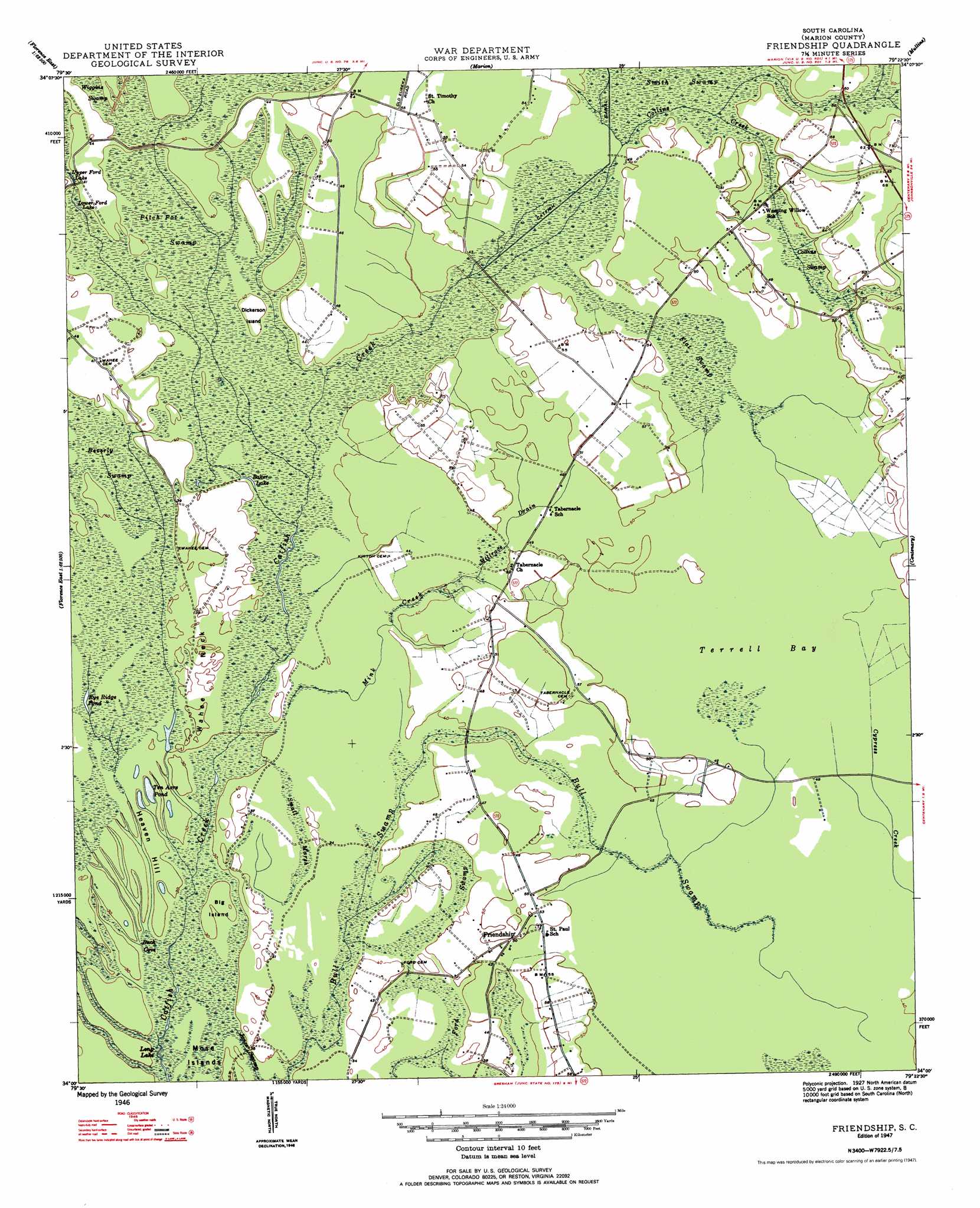
Friendship Topo Map South Carolina
To zoom in, hover over the map of Friendship
USGS Topo Quad 34079a4 - 1:24,000 scale
| Topo Map Name: | Friendship |
| USGS Topo Quad ID: | 34079a4 |
| Print Size: | ca. 21 1/4" wide x 27" high |
| Southeast Coordinates: | 34° N latitude / 79.375° W longitude |
| Map Center Coordinates: | 34.0625° N latitude / 79.4375° W longitude |
| U.S. State: | SC |
| Filename: | o34079a4.jpg |
| Download Map JPG Image: | Friendship topo map 1:24,000 scale |
| Map Type: | Topographic |
| Topo Series: | 7.5´ |
| Map Scale: | 1:24,000 |
| Source of Map Images: | United States Geological Survey (USGS) |
| Alternate Map Versions: |
Friendship SC 1947 Download PDF Buy paper map Friendship SC 1947 Download PDF Buy paper map Friendship SC 2011 Download PDF Buy paper map Friendship SC 2014 Download PDF Buy paper map |
1:24,000 Topo Quads surrounding Friendship
Witherspoon Island |
Oak Grove |
Latta |
Fork |
Lake View |
Florence East |
Pee Dee |
Marion |
Mullins |
Nichols |
Evergreen |
Pamplico North |
Friendship |
Centenary |
Galivants Ferry |
Scranton |
Pamplico South |
Gresham |
Britton Neck |
Horry |
Lake City East |
Prospect Crossroads |
Johnsonville |
Snow Island |
Dongola |
> Back to 34079a1 at 1:100,000 scale
> Back to 34078a1 at 1:250,000 scale
> Back to U.S. Topo Maps home
Friendship topo map: Gazetteer
Friendship: Basins
Terrell Bay elevation 15m 49′Friendship: Capes
Wahee Neck elevation 12m 39′Friendship: Islands
Big Island elevation 9m 29′Dickerson Island elevation 12m 39′
Mose Islands elevation 8m 26′
Friendship: Lakes
Baker Lake elevation 12m 39′Long Lake elevation 9m 29′
Lower Ford Lake elevation 12m 39′
Rye Ridge Pond elevation 10m 32′
Ten Acre Pond elevation 7m 22′
Upper Ford Lake elevation 12m 39′
Friendship: Populated Places
Friendship elevation 15m 49′Tabernacle elevation 15m 49′
Friendship: Streams
Collins Creek elevation 15m 49′Millrace Drain elevation 14m 45′
Mink Creek elevation 10m 32′
Friendship: Summits
Heaven Hill elevation 9m 29′Friendship: Swamps
Beverly Swamp elevation 12m 39′Buck Cove elevation 9m 29′
Collins Swamp elevation 15m 49′
Flat Swamp elevation 15m 49′
Ford Swamp elevation 12m 39′
Pitch Pot Swamp elevation 12m 39′
Small Marsh elevation 11m 36′
Friendship digital topo map on disk
Buy this Friendship topo map showing relief, roads, GPS coordinates and other geographical features, as a high-resolution digital map file on DVD:
South Carolina, Western North Carolina & Northeastern Georgia
Buy digital topo maps: South Carolina, Western North Carolina & Northeastern Georgia