Pee Dee Topo Map South Carolina
To zoom in, hover over the map of Pee Dee
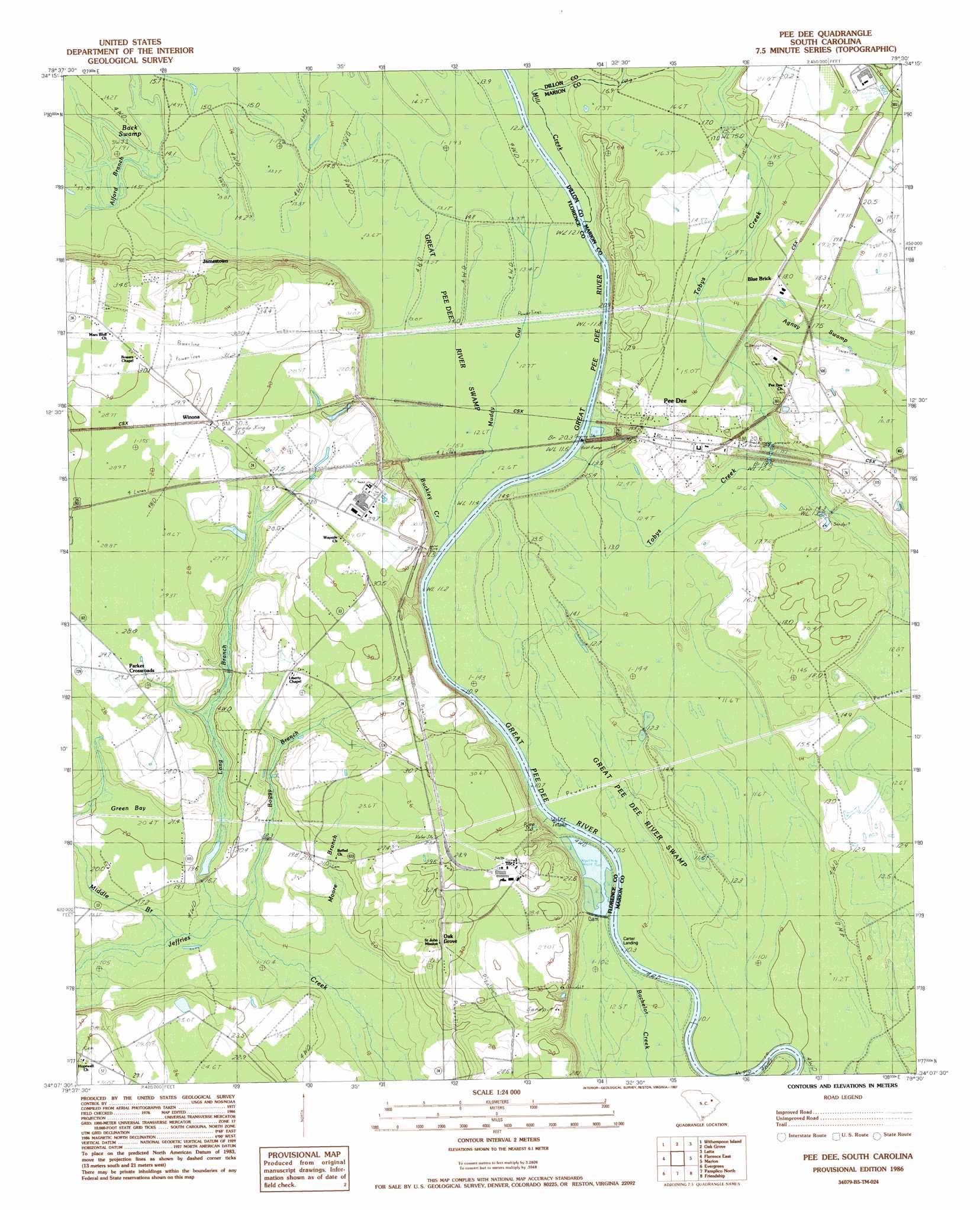
USGS Topo Quad 34079b5 - 1:24,000 scale
| Topo Map Name: | Pee Dee |
| USGS Topo Quad ID: | 34079b5 |
| Print Size: | ca. 21 1/4" wide x 27" high |
| Southeast Coordinates: | 34.125° N latitude / 79.5° W longitude |
| Map Center Coordinates: | 34.1875° N latitude / 79.5625° W longitude |
| U.S. State: | SC |
| Filename: | o34079b5.jpg |
| Download Map JPG Image: | Pee Dee topo map 1:24,000 scale |
| Map Type: | Topographic |
| Topo Series: | 7.5´ |
| Map Scale: | 1:24,000 |
| Source of Map Images: | United States Geological Survey (USGS) |
| Alternate Map Versions: |
Pee Dee SC 1986, updated 1987 Download PDF Buy paper map Pee Dee SC 2011 Download PDF Buy paper map Pee Dee SC 2014 Download PDF Buy paper map |
1:24,000 Topo Quads surrounding Pee Dee
Mont Clare |
Drake |
Bingham |
Dillon West |
Dillon East |
Darlington East |
Witherspoon Island |
Oak Grove |
Latta |
Fork |
Florence West |
Florence East |
Pee Dee |
Marion |
Mullins |
Effingham |
Evergreen |
Pamplico North |
Friendship |
Centenary |
Mill Bay |
Scranton |
Pamplico South |
Gresham |
Britton Neck |
> Back to 34079a1 at 1:100,000 scale
> Back to 34078a1 at 1:250,000 scale
> Back to U.S. Topo Maps home
Pee Dee topo map: Gazetteer
Pee Dee: Bridges
Mars Bluff Bridge elevation 10m 32′Pee Dee: Cliffs
Mars Bluff elevation 26m 85′Pee Dee: Dams
Pepsi Cola Lake Dam D-3562 elevation 15m 49′Pee Dee: Guts
Muddy Gut elevation 13m 42′Pee Dee: Populated Places
Blue Brick elevation 17m 55′Carter Landing elevation 12m 39′
Jamestown elevation 18m 59′
Oak Grove elevation 31m 101′
Parker Crossroads elevation 28m 91′
Pee Dee elevation 18m 59′
Winona elevation 30m 98′
Pee Dee: Reservoirs
Pepsi Cola Lake elevation 15m 49′Pee Dee: Streams
Alford Branch elevation 14m 45′Boggy Branch elevation 16m 52′
Buckley Creek elevation 12m 39′
Cud Swamp elevation 16m 52′
Long Branch elevation 15m 49′
Middle Branch elevation 15m 49′
Mill Creek elevation 13m 42′
Moore Branch elevation 13m 42′
Tobys Creek elevation 10m 32′
Pee Dee: Swamps
Agnay Swamp elevation 16m 52′Back Swamp elevation 14m 45′
Great Pee Dee River Swamp elevation 12m 39′
Green Bay elevation 21m 68′
Pee Dee digital topo map on disk
Buy this Pee Dee topo map showing relief, roads, GPS coordinates and other geographical features, as a high-resolution digital map file on DVD:
South Carolina, Western North Carolina & Northeastern Georgia
Buy digital topo maps: South Carolina, Western North Carolina & Northeastern Georgia