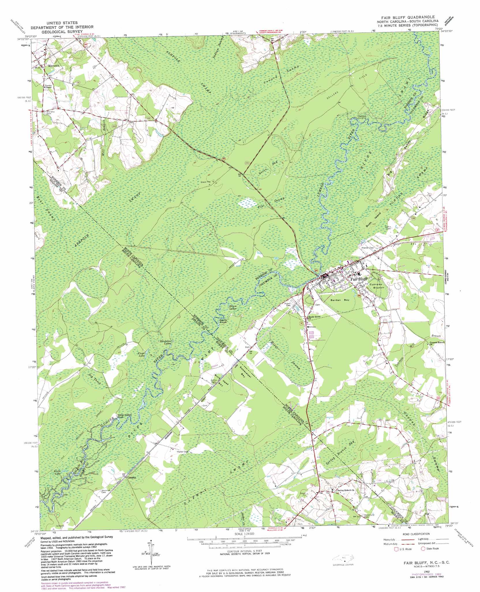
Fair Bluff Topo Map North Carolina
To zoom in, hover over the map of Fair Bluff
USGS Topo Quad 34079c1 - 1:24,000 scale
| Topo Map Name: | Fair Bluff |
| USGS Topo Quad ID: | 34079c1 |
| Print Size: | ca. 21 1/4" wide x 27" high |
| Southeast Coordinates: | 34.25° N latitude / 79° W longitude |
| Map Center Coordinates: | 34.3125° N latitude / 79.0625° W longitude |
| U.S. States: | NC, SC |
| Filename: | o34079c1.jpg |
| Download Map JPG Image: | Fair Bluff topo map 1:24,000 scale |
| Map Type: | Topographic |
| Topo Series: | 7.5´ |
| Map Scale: | 1:24,000 |
| Source of Map Images: | United States Geological Survey (USGS) |
| Alternate Map Versions: |
Fair Bluff NC 1962, updated 1964 Download PDF Buy paper map Fair Bluff NC 1962, updated 1983 Download PDF Buy paper map Fair Bluff NC 1976, updated 1978 Download PDF Buy paper map Fair Bluff NC 2011 Download PDF Buy paper map Fair Bluff NC 2013 Download PDF Buy paper map Fair Bluff NC 2016 Download PDF Buy paper map |
1:24,000 Topo Quads surrounding Fair Bluff
Rowland |
Mcdonald |
Southwest Lumberton |
Southeast Lumberton |
Bladenboro |
Dillon East |
Gaddysville |
Fairmont |
Evergreen |
Chadbourn Ne |
Fork |
Lake View |
Fair Bluff |
Cerro Gordo |
Chadbourn |
Mullins |
Nichols |
Duford |
Tabor City West |
Tabor City East |
Centenary |
Galivants Ferry |
Bayboro |
Loris |
Goretown |
> Back to 34079a1 at 1:100,000 scale
> Back to 34078a1 at 1:250,000 scale
> Back to U.S. Topo Maps home
Fair Bluff topo map: Gazetteer
Fair Bluff: Basins
Buck Head Bay elevation 19m 62′Sawscapel Bay elevation 20m 65′
Fair Bluff: Bays
Sawscalpel Bay elevation 20m 65′Fair Bluff: Bends
Devils Elbow elevation 16m 52′Fair Bluff: Cliffs
Watermelon Bluff elevation 15m 49′Fair Bluff: Flats
Sellers Field elevation 20m 65′Fair Bluff: Islands
Bush Island elevation 19m 62′Fair Bluff: Lakes
Deadman Lakes elevation 16m 52′Floyd Lake elevation 17m 55′
Heron Lakes elevation 17m 55′
White Lake elevation 15m 49′
Fair Bluff: Populated Places
Causey elevation 16m 52′Fair Bluff elevation 19m 62′
Marietta elevation 28m 91′
Fair Bluff: Post Offices
Fair Bluff Post Office elevation 19m 62′Fair Bluff: Ridges
Big Sandy Ridge elevation 22m 72′Fair Bluff: Streams
Bear Swamp elevation 19m 62′Coleman Mill Branch elevation 20m 65′
Indian Swamp elevation 20m 65′
Jordan Creek elevation 18m 59′
Mill Branch elevation 19m 62′
Fair Bluff: Swamps
Ashpole Swamp elevation 19m 62′Barden Bay elevation 19m 62′
Big Thick elevation 17m 55′
Coward Swamp elevation 20m 65′
Cypress Branch elevation 21m 68′
Flat Swamp elevation 18m 59′
Gapway Swamp elevation 19m 62′
Gapway Swamp elevation 17m 55′
Green Bay elevation 20m 65′
Horne Swamp elevation 20m 65′
River Swamp elevation 18m 59′
Spring Branch Bay elevation 21m 68′
Spring Branch Bay elevation 22m 72′
Fair Bluff digital topo map on disk
Buy this Fair Bluff topo map showing relief, roads, GPS coordinates and other geographical features, as a high-resolution digital map file on DVD:
South Carolina, Western North Carolina & Northeastern Georgia
Buy digital topo maps: South Carolina, Western North Carolina & Northeastern Georgia