Fork Topo Map South Carolina
To zoom in, hover over the map of Fork
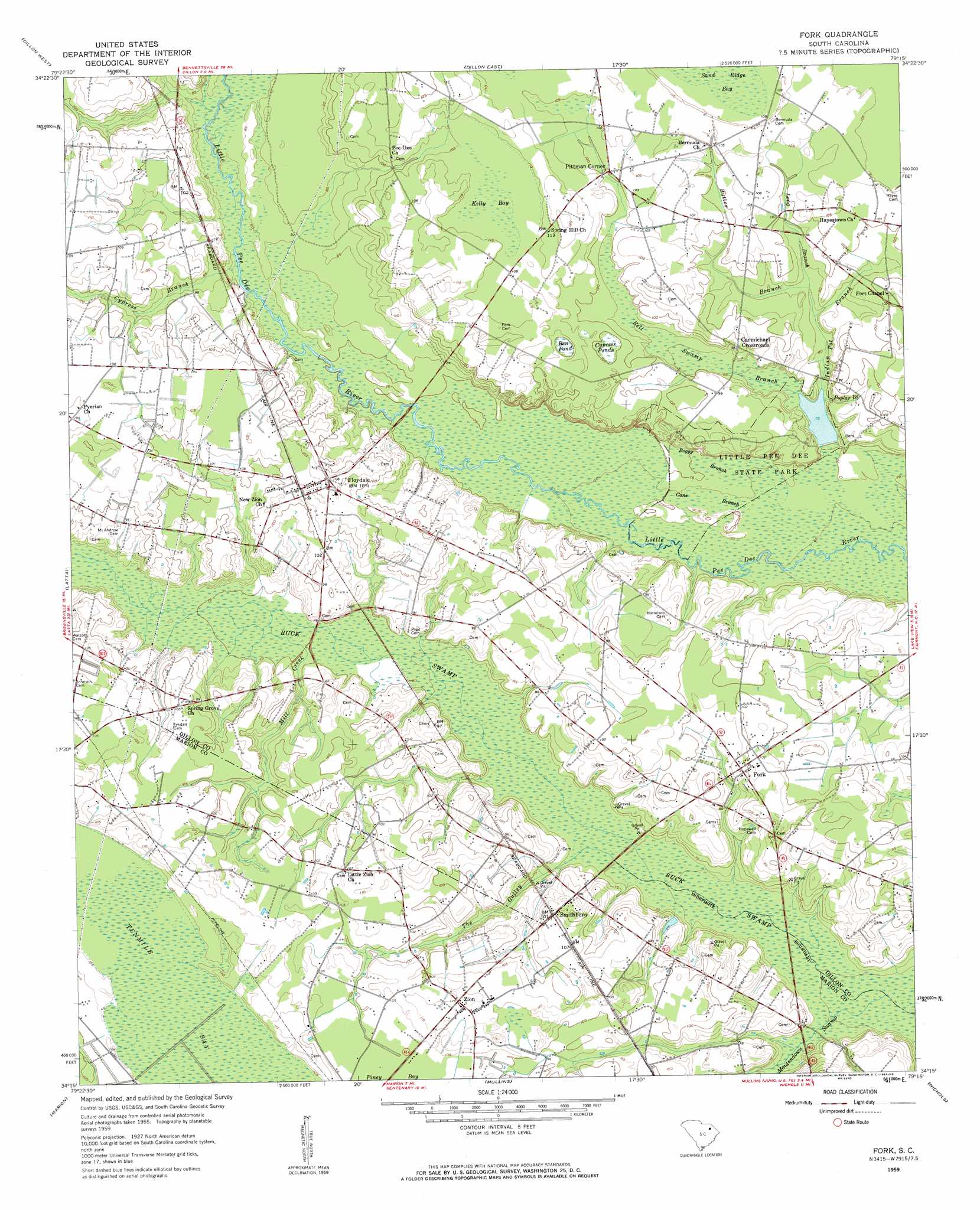
USGS Topo Quad 34079c3 - 1:24,000 scale
| Topo Map Name: | Fork |
| USGS Topo Quad ID: | 34079c3 |
| Print Size: | ca. 21 1/4" wide x 27" high |
| Southeast Coordinates: | 34.25° N latitude / 79.25° W longitude |
| Map Center Coordinates: | 34.3125° N latitude / 79.3125° W longitude |
| U.S. State: | SC |
| Filename: | o34079c3.jpg |
| Download Map JPG Image: | Fork topo map 1:24,000 scale |
| Map Type: | Topographic |
| Topo Series: | 7.5´ |
| Map Scale: | 1:24,000 |
| Source of Map Images: | United States Geological Survey (USGS) |
| Alternate Map Versions: |
Fork SC 1959, updated 1961 Download PDF Buy paper map Fork SC 2011 Download PDF Buy paper map Fork SC 2014 Download PDF Buy paper map |
1:24,000 Topo Quads surrounding Fork
Clio |
Minturn |
Rowland |
Mcdonald |
Southwest Lumberton |
Bingham |
Dillon West |
Dillon East |
Gaddysville |
Fairmont |
Oak Grove |
Latta |
Fork |
Lake View |
Fair Bluff |
Pee Dee |
Marion |
Mullins |
Nichols |
Duford |
Pamplico North |
Friendship |
Centenary |
Galivants Ferry |
Bayboro |
> Back to 34079a1 at 1:100,000 scale
> Back to 34078a1 at 1:250,000 scale
> Back to U.S. Topo Maps home
Fork topo map: Gazetteer
Fork: Dams
Fowlers Second Pond Dam D-3607 elevation 24m 78′Fowlers Third Pond Dam D-3606 elevation 24m 78′
Prr Dee State Park Dam D-3602 elevation 23m 75′
Spiveys 917 Pond Dam D-3605 elevation 22m 72′
Fork: Guts
Boggy Branch elevation 22m 72′Cane Branch elevation 21m 68′
Fork: Parks
Little Pee Dee State Park elevation 29m 95′Fork: Populated Places
Carmichael Crossroads elevation 29m 95′Dunbarton elevation 23m 75′
Floydale elevation 33m 108′
Fork elevation 30m 98′
Hayestown elevation 32m 104′
Pittman Corner elevation 30m 98′
Smithboro elevation 30m 98′
Zion elevation 33m 108′
Fork: Post Offices
Fork Post Office elevation 28m 91′Fork: Reservoirs
Pee Dee State Park Lake elevation 23m 75′Fork: Streams
Bell Swamp Branch elevation 23m 75′Butler Branch elevation 26m 85′
Cypress Branch elevation 24m 78′
Indian Pot Branch elevation 23m 75′
Long Branch elevation 25m 82′
Maidendown Swamp elevation 17m 55′
Maple Swamp elevation 24m 78′
Mill Creek elevation 22m 72′
Poplar Branch elevation 23m 75′
The Gulley elevation 20m 65′
Fork: Swamps
Ben Pond elevation 30m 98′Buck Swamp elevation 20m 65′
Cypress Ponds elevation 30m 98′
Kelly Bay elevation 32m 104′
Tenmile Bay elevation 31m 101′
Fork digital topo map on disk
Buy this Fork topo map showing relief, roads, GPS coordinates and other geographical features, as a high-resolution digital map file on DVD:
South Carolina, Western North Carolina & Northeastern Georgia
Buy digital topo maps: South Carolina, Western North Carolina & Northeastern Georgia