Mcdonald Topo Map North Carolina
To zoom in, hover over the map of Mcdonald
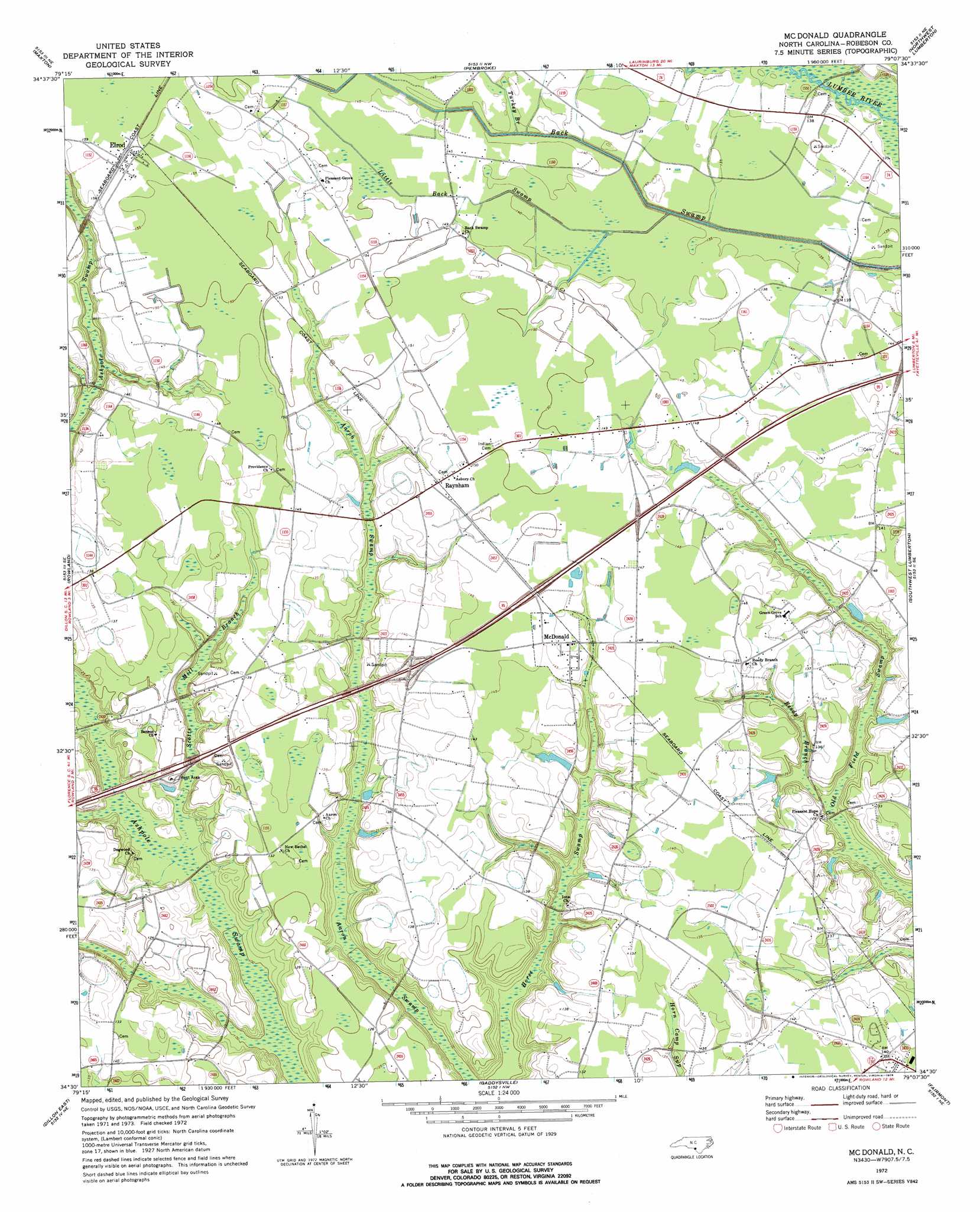
USGS Topo Quad 34079e2 - 1:24,000 scale
| Topo Map Name: | Mcdonald |
| USGS Topo Quad ID: | 34079e2 |
| Print Size: | ca. 21 1/4" wide x 27" high |
| Southeast Coordinates: | 34.5° N latitude / 79.125° W longitude |
| Map Center Coordinates: | 34.5625° N latitude / 79.1875° W longitude |
| U.S. State: | NC |
| Filename: | o34079e2.jpg |
| Download Map JPG Image: | Mcdonald topo map 1:24,000 scale |
| Map Type: | Topographic |
| Topo Series: | 7.5´ |
| Map Scale: | 1:24,000 |
| Source of Map Images: | United States Geological Survey (USGS) |
| Alternate Map Versions: |
Mc Donald NC 1972, updated 1976 Download PDF Buy paper map Mc Donald NC 1976, updated 1978 Download PDF Buy paper map Mc Donald NC 1981, updated 1985 Download PDF Buy paper map McDonald NC 2010 Download PDF Buy paper map McDonald NC 2013 Download PDF Buy paper map McDonald NC 2016 Download PDF Buy paper map |
1:24,000 Topo Quads surrounding Mcdonald
Laurinburg |
Wakulla |
Red Springs |
Rennert |
Saint Pauls |
Johns |
Maxton |
Pembroke |
Northwest Lumberton |
Northeast Lumberton |
Minturn |
Rowland |
Mcdonald |
Southwest Lumberton |
Southeast Lumberton |
Dillon West |
Dillon East |
Gaddysville |
Fairmont |
Evergreen |
Latta |
Fork |
Lake View |
Fair Bluff |
Cerro Gordo |
> Back to 34079e1 at 1:100,000 scale
> Back to 34078a1 at 1:250,000 scale
> Back to U.S. Topo Maps home
Mcdonald topo map: Gazetteer
Mcdonald: Populated Places
Elrod elevation 49m 160′McDonald elevation 45m 147′
Raynham elevation 45m 147′
Mcdonald: Streams
Little Back Swamp elevation 41m 134′Turkey Branch elevation 42m 137′
Mcdonald: Swamps
Aaron Swamp elevation 34m 111′Ashpole Swamp elevation 31m 101′
Horse Swamp elevation 32m 104′
Reedy Branch elevation 37m 121′
Scotts Mill Branch elevation 35m 114′
Mcdonald digital topo map on disk
Buy this Mcdonald topo map showing relief, roads, GPS coordinates and other geographical features, as a high-resolution digital map file on DVD:
South Carolina, Western North Carolina & Northeastern Georgia
Buy digital topo maps: South Carolina, Western North Carolina & Northeastern Georgia