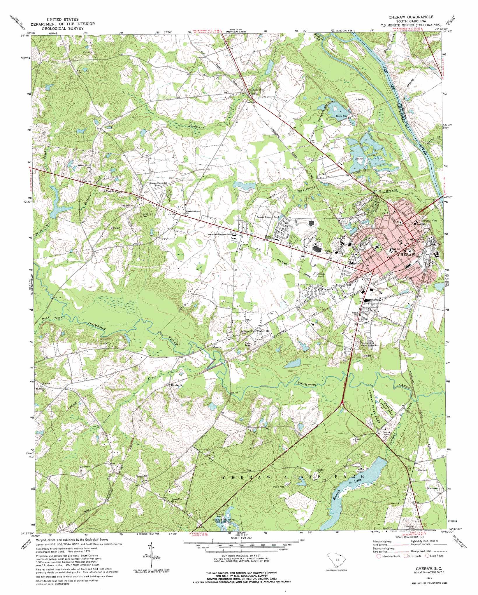
Cheraw Topo Map South Carolina
To zoom in, hover over the map of Cheraw
USGS Topo Quad 34079f8 - 1:24,000 scale
| Topo Map Name: | Cheraw |
| USGS Topo Quad ID: | 34079f8 |
| Print Size: | ca. 21 1/4" wide x 27" high |
| Southeast Coordinates: | 34.625° N latitude / 79.875° W longitude |
| Map Center Coordinates: | 34.6875° N latitude / 79.9375° W longitude |
| U.S. State: | SC |
| Filename: | o34079f8.jpg |
| Download Map JPG Image: | Cheraw topo map 1:24,000 scale |
| Map Type: | Topographic |
| Topo Series: | 7.5´ |
| Map Scale: | 1:24,000 |
| Source of Map Images: | United States Geological Survey (USGS) |
| Alternate Map Versions: |
Cheraw SC 1971, updated 1976 Download PDF Buy paper map Cheraw SC 2011 Download PDF Buy paper map Cheraw SC 2014 Download PDF Buy paper map |
1:24,000 Topo Quads surrounding Cheraw
Russellville |
Wadesboro |
Lilesville |
Rockingham |
Hamlet |
Mount Croghan |
Morven West |
Morven East |
Diggs |
Ghio |
Ruby |
Chesterfield |
Cheraw |
Wallace |
Bennettsville North |
Middendorf |
Patrick |
Cash |
Society Hill |
Bennettsville South |
Lake Robinson |
Hartsville North |
Dovesville |
Mont Clare |
Drake |
> Back to 34079e1 at 1:100,000 scale
> Back to 34078a1 at 1:250,000 scale
> Back to U.S. Topo Maps home
Cheraw topo map: Gazetteer
Cheraw: Airports
Cheraw Municipal Airport elevation 64m 209′Cheraw: Dams
Bridlewood Lower Lake Dam D-3237 elevation 42m 137′Bridlewood Upper Lake Dam D-3236 elevation 46m 150′
Cheathan Lake Dam D-3219 elevation 36m 118′
Cheraw State Park Two Dam D-3224 elevation 44m 144′
Clyde Laney Pond Dam D-3217 elevation 45m 147′
Eskridge Pond Dam D-3221 elevation 46m 150′
Eureka Lake Dam D-3225 elevation 30m 98′
Fish Hatchery Lake One Dam D-3222 elevation 42m 137′
Fish Hatchery Lake Two Dam D-3223 elevation 38m 124′
L C Reid Pond Dam D-3220 elevation 40m 131′
South Carolina Noname 13011 D-3216 Dam elevation 40m 131′
Cheraw: Islands
Big Island elevation 29m 95′Cane Island elevation 29m 95′
Cheraw: Parks
Caston Park elevation 51m 167′Cheraw Historic District elevation 47m 154′
Cheraw State Park elevation 42m 137′
Riverside Park elevation 30m 98′
Southside Park elevation 37m 121′
Cheraw: Populated Places
Cheraw elevation 47m 154′Excelsior (historical) elevation 53m 173′
Fisher Hill elevation 56m 183′
Gillespie (historical) elevation 73m 239′
Isgett Circle elevation 52m 170′
Kimberly elevation 35m 114′
McNeils (historical) elevation 31m 101′
Robinson elevation 44m 144′
Thompsons (historical) elevation 49m 160′
Windsor Park elevation 53m 173′
Cheraw: Post Offices
Cheraw Post Office elevation 49m 160′Cheraw: Reservoirs
Eureka Lake elevation 30m 98′Gaddy Pond elevation 40m 131′
Laney Pond elevation 45m 147′
Cheraw: Streams
Bear Creek elevation 31m 101′Beaver Creek elevation 28m 91′
Hicks Creek elevation 24m 78′
Huckleberry Branch elevation 24m 78′
Husbands Creek elevation 23m 75′
Juniper Creek elevation 24m 78′
Landy Creek elevation 32m 104′
Little Pedee River elevation 24m 78′
Pee Dee River elevation 22m 72′
Sixmile Creek elevation 41m 134′
Westfield Creek elevation 22m 72′
Whites Creek elevation 24m 78′
Wilson Branch elevation 32m 104′
Cheraw digital topo map on disk
Buy this Cheraw topo map showing relief, roads, GPS coordinates and other geographical features, as a high-resolution digital map file on DVD:
South Carolina, Western North Carolina & Northeastern Georgia
Buy digital topo maps: South Carolina, Western North Carolina & Northeastern Georgia