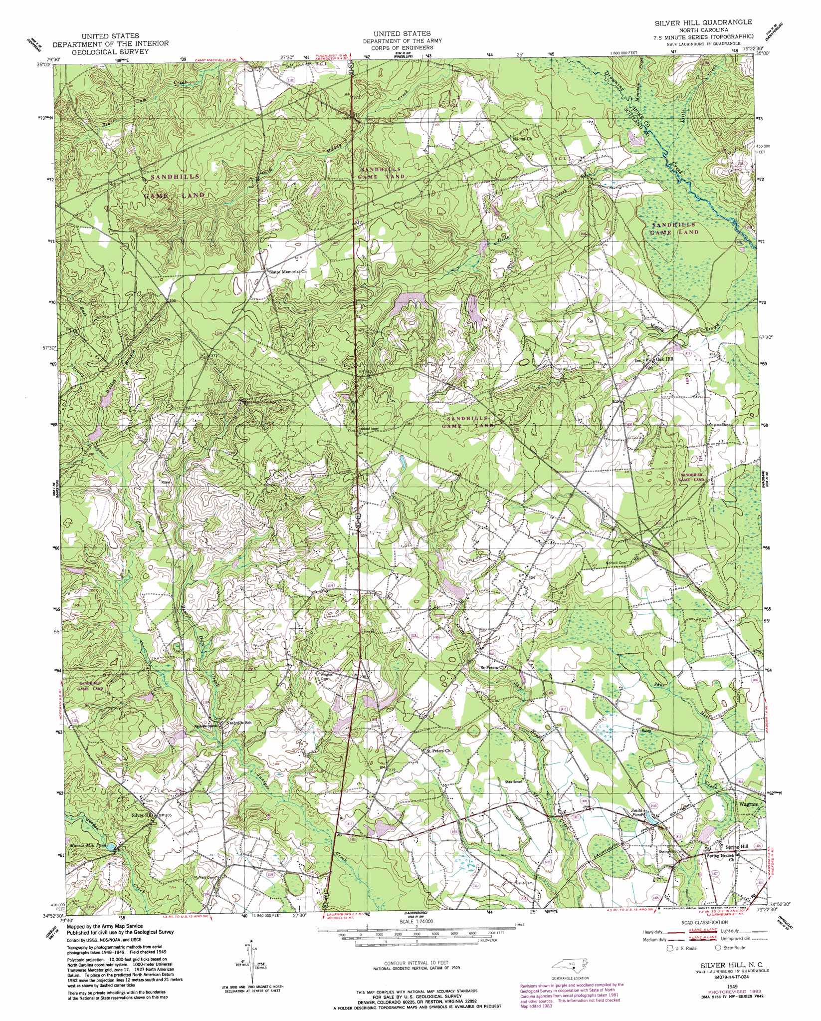
Silver Hill Topo Map North Carolina
To zoom in, hover over the map of Silver Hill
USGS Topo Quad 34079h4 - 1:24,000 scale
| Topo Map Name: | Silver Hill |
| USGS Topo Quad ID: | 34079h4 |
| Print Size: | ca. 21 1/4" wide x 27" high |
| Southeast Coordinates: | 34.875° N latitude / 79.375° W longitude |
| Map Center Coordinates: | 34.9375° N latitude / 79.4375° W longitude |
| U.S. State: | NC |
| Filename: | o34079h4.jpg |
| Download Map JPG Image: | Silver Hill topo map 1:24,000 scale |
| Map Type: | Topographic |
| Topo Series: | 7.5´ |
| Map Scale: | 1:24,000 |
| Source of Map Images: | United States Geological Survey (USGS) |
| Alternate Map Versions: |
Silver Hill NC 1949, updated 1953 Download PDF Buy paper map Silver Hill NC 1949, updated 1983 Download PDF Buy paper map Silver Hill NC 1949, updated 1983 Download PDF Buy paper map Silver Hill NC 1976, updated 1978 Download PDF Buy paper map Silver Hill NC 2010 Download PDF Buy paper map Silver Hill NC 2013 Download PDF Buy paper map Silver Hill NC 2016 Download PDF Buy paper map |
1:24,000 Topo Quads surrounding Silver Hill
Norman |
West End |
Southern Pines |
Niagara |
Lobelia |
Millstone Lake |
Hoffman |
Pinebluff |
Mccain |
Nicholson Creek |
Hamlet |
Marston |
Silver Hill |
Wagram |
Raeford |
Ghio |
Gibson |
Laurinburg |
Wakulla |
Red Springs |
Bennettsville North |
Mccoll |
Johns |
Maxton |
Pembroke |
> Back to 34079e1 at 1:100,000 scale
> Back to 34078a1 at 1:250,000 scale
> Back to U.S. Topo Maps home
Silver Hill topo map: Gazetteer
Silver Hill: Dams
Dixie Pond Dam elevation 90m 295′Newtons Pond Dam elevation 76m 249′
Silver Hill: Populated Places
Oak Hill elevation 84m 275′Silver Hill elevation 92m 301′
Spring Hill elevation 73m 239′
Silver Hill: Reservoirs
Dixie Pond elevation 90m 295′Monroe Mill Pond elevation 79m 259′
Newtons Pond elevation 76m 249′
Smith Pond elevation 75m 246′
Silver Hill: Streams
Beaver Dam Creek elevation 73m 239′East Prong Juniper Creek elevation 89m 291′
Hills Creek elevation 72m 236′
Little Creek elevation 72m 236′
Mountain Creek elevation 73m 239′
West Prong Juniper Creek elevation 89m 291′
Wilkes Branch elevation 87m 285′
Silver Hill digital topo map on disk
Buy this Silver Hill topo map showing relief, roads, GPS coordinates and other geographical features, as a high-resolution digital map file on DVD:
South Carolina, Western North Carolina & Northeastern Georgia
Buy digital topo maps: South Carolina, Western North Carolina & Northeastern Georgia