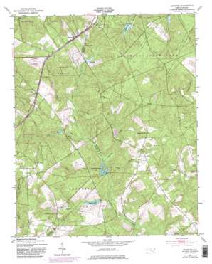
Marston Topo Map North Carolina
To zoom in, hover over the map of Marston
USGS Topo Quad 34079h5 - 1:24,000 scale
| Topo Map Name: | Marston |
| USGS Topo Quad ID: | 34079h5 |
| Print Size: | ca. 21 1/4" wide x 27" high |
| Southeast Coordinates: | 34.875° N latitude / 79.5° W longitude |
| Map Center Coordinates: | 34.9375° N latitude / 79.5625° W longitude |
| U.S. State: | NC |
| Filename: | o34079h5.jpg |
| Download Map JPG Image: | Marston topo map 1:24,000 scale |
| Map Type: | Topographic |
| Topo Series: | 7.5´ |
| Map Scale: | 1:24,000 |
| Source of Map Images: | United States Geological Survey (USGS) |
| Alternate Map Versions: |
Marston NC 1949, updated 1953 Download PDF Buy paper map Marston NC 1949, updated 1965 Download PDF Buy paper map Marston NC 1949, updated 1983 Download PDF Buy paper map Marston NC 1949, updated 1983 Download PDF Buy paper map Marston NC 1976, updated 1978 Download PDF Buy paper map Marston NC 2010 Download PDF Buy paper map Marston NC 2013 Download PDF Buy paper map Marston NC 2016 Download PDF Buy paper map |
1:24,000 Topo Quads surrounding Marston
> Back to 34079e1 at 1:100,000 scale
> Back to 34078a1 at 1:250,000 scale
> Back to U.S. Topo Maps home
Marston topo map: Gazetteer
Marston: Dams
Crawford Lake Dam elevation 78m 255′Gum Swamp Lake Dam elevation 77m 252′
Kinney Cameron Lake Dam elevation 104m 341′
Laurel Hill Dam elevation 85m 278′
Pine Lake Dam elevation 100m 328′
Marston: Populated Places
Cognac elevation 120m 393′Marston elevation 129m 423′
Marston: Post Offices
Cognac Post Office (historical) elevation 120m 393′Marston: Reservoirs
Camerons Lake elevation 108m 354′Catawba Lake elevation 85m 278′
Crawford Lake elevation 78m 255′
Gum Swamp Lake elevation 77m 252′
Kinney Cameron Lake elevation 104m 341′
McLeods Lake elevation 88m 288′
Pine Lake elevation 97m 318′
Marston: Streams
Camp Branch elevation 79m 259′Clay Branch elevation 86m 282′
Crawford Branch elevation 72m 236′
Fergerson Branch elevation 91m 298′
Mill Creek elevation 81m 265′
Tuckahoe Branch elevation 78m 255′
Undermine Branch elevation 77m 252′
Marston digital topo map on disk
Buy this Marston topo map showing relief, roads, GPS coordinates and other geographical features, as a high-resolution digital map file on DVD:
South Carolina, Western North Carolina & Northeastern Georgia
Buy digital topo maps: South Carolina, Western North Carolina & Northeastern Georgia


