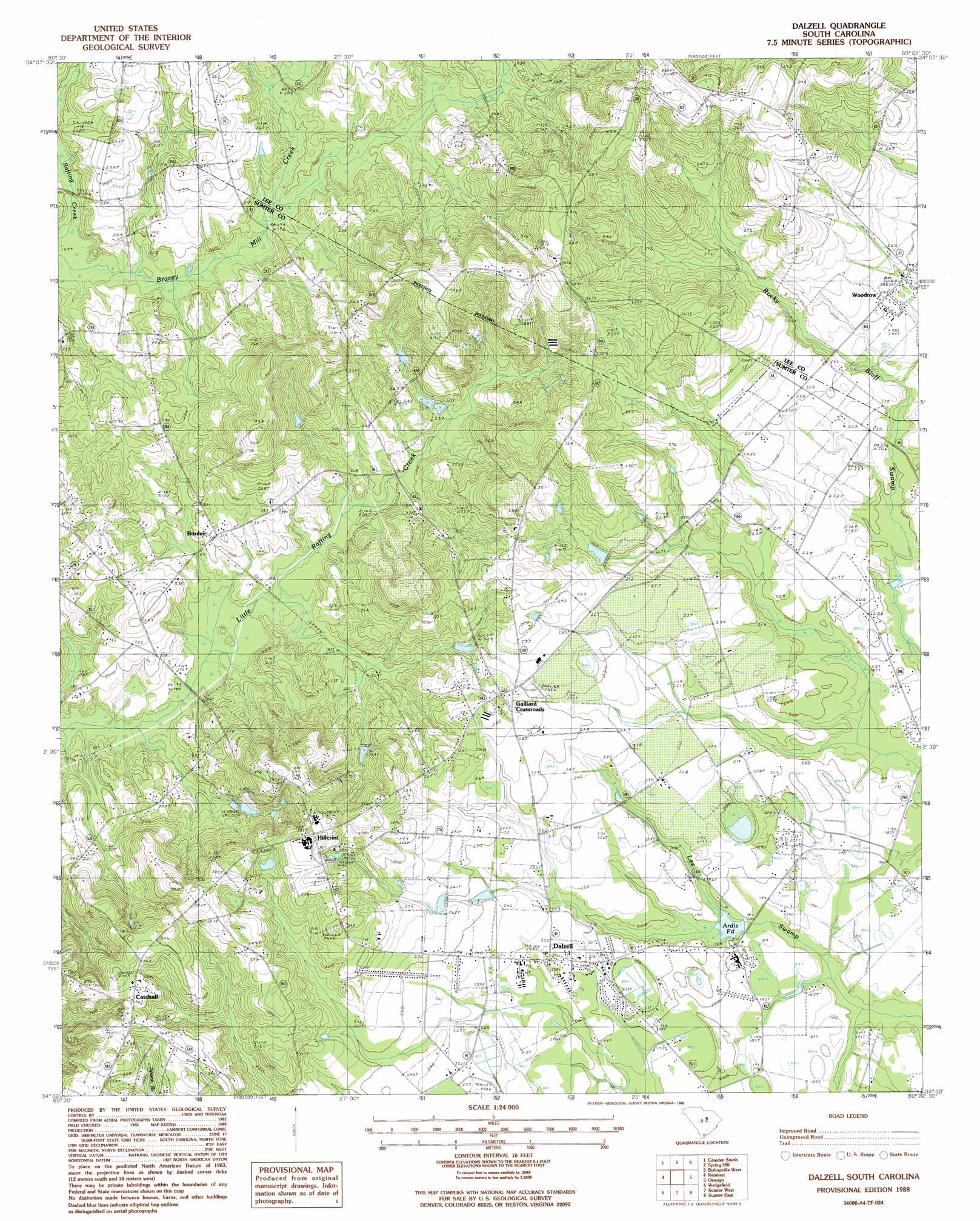
Dalzell Topo Map South Carolina
To zoom in, hover over the map of Dalzell
USGS Topo Quad 34080a4 - 1:24,000 scale
| Topo Map Name: | Dalzell |
| USGS Topo Quad ID: | 34080a4 |
| Print Size: | ca. 21 1/4" wide x 27" high |
| Southeast Coordinates: | 34° N latitude / 80.375° W longitude |
| Map Center Coordinates: | 34.0625° N latitude / 80.4375° W longitude |
| U.S. State: | SC |
| Filename: | o34080a4.jpg |
| Download Map JPG Image: | Dalzell topo map 1:24,000 scale |
| Map Type: | Topographic |
| Topo Series: | 7.5´ |
| Map Scale: | 1:24,000 |
| Source of Map Images: | United States Geological Survey (USGS) |
| Alternate Map Versions: |
Dalzell SC 1988, updated 1988 Download PDF Buy paper map Dalzell SC 2011 Download PDF Buy paper map Dalzell SC 2014 Download PDF Buy paper map |
1:24,000 Topo Quads surrounding Dalzell
Rabon Crossroads |
Camden North |
Cassatt |
Lucknow |
Kellytown |
Lugoff |
Camden South |
Spring Hill |
Bishopville West |
Bishopville East |
Leesburg |
Rembert |
Dalzell |
Oswego |
Elliott |
Eastover |
Wedgefield |
Sumter West |
Sumter East |
Mayesville |
Wateree |
Poinsett State Park |
Privateer |
Brogdon |
Tearcoat Branch |
> Back to 34080a1 at 1:100,000 scale
> Back to 34080a1 at 1:250,000 scale
> Back to U.S. Topo Maps home
Dalzell topo map: Gazetteer
Dalzell: Dams
Ardis Pond Dam D-1979 elevation 71m 232′Barnett Pond Dam D-1976 elevation 74m 242′
Lake View Pond Dam D-1977 elevation 81m 265′
Norsworthy Pond Dam D-1975 elevation 89m 291′
Ross Pond Dam D-1978 elevation 67m 219′
Dalzell: Lakes
Ardis Pond elevation 58m 190′Dalzell: Populated Places
Borden elevation 63m 206′Burrows Crossroads elevation 77m 252′
Catchall elevation 115m 377′
Dalzell elevation 66m 216′
Gaillard Crossroads elevation 85m 278′
Hillcrest elevation 119m 390′
Pecan Acres elevation 79m 259′
Woodrow elevation 74m 242′
Dalzell: Post Offices
Dalzell Post Office elevation 67m 219′Dalzell: Reservoirs
Ardis Pond elevation 71m 232′Barnett Pond elevation 74m 242′
Lake View Pond elevation 81m 265′
Norsworthy Pond elevation 89m 291′
Ross Pond elevation 67m 219′
Dalzell: Streams
Bracey Mill Creek elevation 51m 167′Dalzell digital topo map on disk
Buy this Dalzell topo map showing relief, roads, GPS coordinates and other geographical features, as a high-resolution digital map file on DVD:
South Carolina, Western North Carolina & Northeastern Georgia
Buy digital topo maps: South Carolina, Western North Carolina & Northeastern Georgia