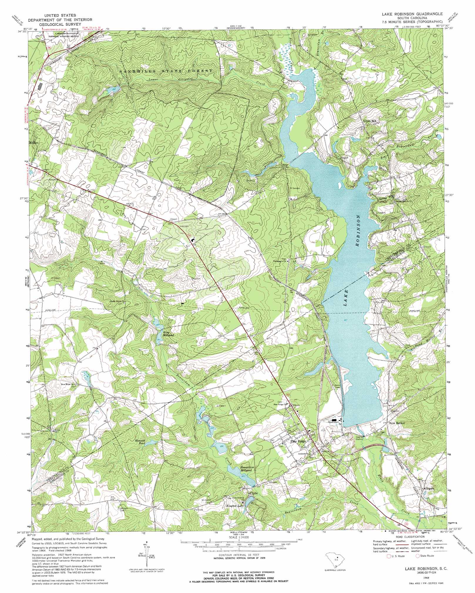
Lake Robinson Topo Map South Carolina
To zoom in, hover over the map of Lake Robinson
USGS Topo Quad 34080d2 - 1:24,000 scale
| Topo Map Name: | Lake Robinson |
| USGS Topo Quad ID: | 34080d2 |
| Print Size: | ca. 21 1/4" wide x 27" high |
| Southeast Coordinates: | 34.375° N latitude / 80.125° W longitude |
| Map Center Coordinates: | 34.4375° N latitude / 80.1875° W longitude |
| U.S. State: | SC |
| Filename: | o34080d2.jpg |
| Download Map JPG Image: | Lake Robinson topo map 1:24,000 scale |
| Map Type: | Topographic |
| Topo Series: | 7.5´ |
| Map Scale: | 1:24,000 |
| Source of Map Images: | United States Geological Survey (USGS) |
| Alternate Map Versions: |
Lake Robinson SC 1968, updated 1971 Download PDF Buy paper map Lake Robinson SC 1968, updated 1991 Download PDF Buy paper map Lake Robinson SC 2011 Download PDF Buy paper map Lake Robinson SC 2014 Download PDF Buy paper map |
1:24,000 Topo Quads surrounding Lake Robinson
Jefferson |
Jefferson Ne |
Ruby |
Chesterfield |
Cheraw |
Mount Pisgah |
Angelus |
Middendorf |
Patrick |
Cash |
Bethune Nw |
Bethune |
Lake Robinson |
Hartsville North |
Dovesville |
Cassatt |
Lucknow |
Kellytown |
Hartsville South |
Darlington West |
Spring Hill |
Bishopville West |
Bishopville East |
Lamar |
Timmonsville |
> Back to 34080a1 at 1:100,000 scale
> Back to 34080a1 at 1:250,000 scale
> Back to U.S. Topo Maps home
Lake Robinson topo map: Gazetteer
Lake Robinson: Dams
C P and L Slag Pond Dam D-3514 elevation 79m 259′Charlie Luthers Pond Dam D-3510 elevation 77m 252′
Harmon Pond Dam D-3201 elevation 91m 298′
Hilton Kings Pond Dam D-3511 elevation 72m 236′
Ington Lake Dam D-3513 elevation 72m 236′
King Millpond Dam D-3202 elevation 84m 275′
South Carolina Noname 16014 D-3512 Dam elevation 67m 219′
South Carolina Noname 16033 Dam elevation 64m 209′
Sowells Pond Dam D-1832 elevation 112m 367′
Lake Robinson: Lakes
Hannah Pond elevation 81m 265′Joe Pond elevation 81m 265′
Lake Robinson: Populated Places
Clyde elevation 78m 255′Green Hill elevation 100m 328′
Ingrams elevation 136m 446′
Leland elevation 92m 301′
New Market elevation 64m 209′
Pine Ridge elevation 80m 262′
Segars elevation 73m 239′
Tabernacle (historical) elevation 86m 282′
Lake Robinson: Reservoirs
Beaverdam Millpond elevation 68m 223′Clyde Millpond elevation 67m 219′
King Millpond elevation 84m 275′
Kington Lake elevation 72m 236′
Lake Robinson elevation 67m 219′
Lake Robinson elevation 64m 209′
Lake Robinson: Streams
Big Beaverdam Creek elevation 68m 223′Little Beaverdam Branch elevation 68m 223′
Lower Alligator Creek elevation 68m 223′
Pond Hollow Branch elevation 67m 219′
Spring Branch elevation 82m 269′
Lake Robinson digital topo map on disk
Buy this Lake Robinson topo map showing relief, roads, GPS coordinates and other geographical features, as a high-resolution digital map file on DVD:
South Carolina, Western North Carolina & Northeastern Georgia
Buy digital topo maps: South Carolina, Western North Carolina & Northeastern Georgia