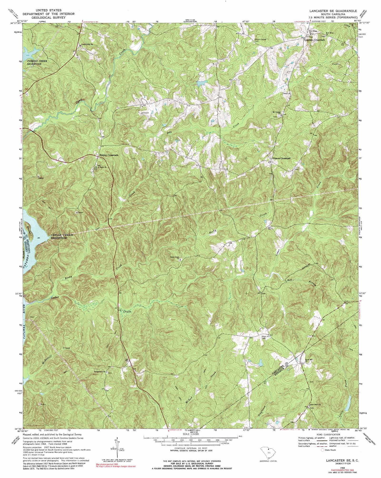
Lancaster Se Topo Map South Carolina
To zoom in, hover over the map of Lancaster Se
USGS Topo Quad 34080e7 - 1:24,000 scale
| Topo Map Name: | Lancaster Se |
| USGS Topo Quad ID: | 34080e7 |
| Print Size: | ca. 21 1/4" wide x 27" high |
| Southeast Coordinates: | 34.5° N latitude / 80.75° W longitude |
| Map Center Coordinates: | 34.5625° N latitude / 80.8125° W longitude |
| U.S. State: | SC |
| Filename: | o34080e7.jpg |
| Download Map JPG Image: | Lancaster Se topo map 1:24,000 scale |
| Map Type: | Topographic |
| Topo Series: | 7.5´ |
| Map Scale: | 1:24,000 |
| Source of Map Images: | United States Geological Survey (USGS) |
| Alternate Map Versions: |
Lancaster SE SC 1968, updated 1971 Download PDF Buy paper map Lancaster SE SC 1968, updated 1992 Download PDF Buy paper map Lancaster SE SC 2011 Download PDF Buy paper map Lancaster SE SC 2014 Download PDF Buy paper map |
1:24,000 Topo Quads surrounding Lancaster Se
Edgemoor |
Catawba |
Van Wyck |
Unity |
Tradesville |
Richburg |
Fort Lawn |
Lancaster |
Antioch |
Taxahaw |
Stover |
Great Falls |
Lancaster Se |
Heath Springs |
Kershaw |
Winnsboro |
Flint Hill |
Liberty Hill |
Whiteoak Creek |
Westville |
Winnsboro Mills |
Ridgeway |
Longtown |
Rabon Crossroads |
Camden North |
> Back to 34080e1 at 1:100,000 scale
> Back to 34080a1 at 1:250,000 scale
> Back to U.S. Topo Maps home
Lancaster Se topo map: Gazetteer
Lancaster Se: Dams
Bowater Camp Creek Pond Dam D-1764 elevation 138m 452′Cedar Creek Dam elevation 80m 262′
Lancaster Se: Islands
Bowden Island elevation 95m 311′Lancaster Se: Populated Places
Blakley Crossroads elevation 151m 495′Cauthens Crossroads elevation 185m 606′
Kingsbury (historical) elevation 70m 229′
Pitmon Crossroad elevation 168m 551′
Warrington elevation 169m 554′
Lancaster Se: Reservoirs
Rock and Cedar Creek Reservoir elevation 80m 262′Lancaster Se: Streams
Bell Branch elevation 100m 328′Cedar Creek elevation 70m 229′
Dry Creek elevation 106m 347′
Gar Creek elevation 76m 249′
McDowell Creek elevation 70m 229′
Rocky Creek elevation 71m 232′
Lancaster Se digital topo map on disk
Buy this Lancaster Se topo map showing relief, roads, GPS coordinates and other geographical features, as a high-resolution digital map file on DVD:
South Carolina, Western North Carolina & Northeastern Georgia
Buy digital topo maps: South Carolina, Western North Carolina & Northeastern Georgia