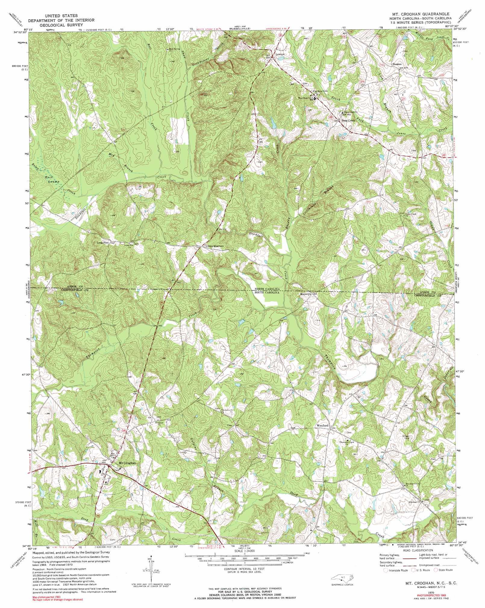
Mount Croghan Topo Map North Carolina
To zoom in, hover over the map of Mount Croghan
USGS Topo Quad 34080g2 - 1:24,000 scale
| Topo Map Name: | Mount Croghan |
| USGS Topo Quad ID: | 34080g2 |
| Print Size: | ca. 21 1/4" wide x 27" high |
| Southeast Coordinates: | 34.75° N latitude / 80.125° W longitude |
| Map Center Coordinates: | 34.8125° N latitude / 80.1875° W longitude |
| U.S. States: | NC, SC |
| Filename: | o34080g2.jpg |
| Download Map JPG Image: | Mount Croghan topo map 1:24,000 scale |
| Map Type: | Topographic |
| Topo Series: | 7.5´ |
| Map Scale: | 1:24,000 |
| Source of Map Images: | United States Geological Survey (USGS) |
| Alternate Map Versions: |
Mt. Croghan SC 1970, updated 1973 Download PDF Buy paper map Mt. Croghan SC 1970, updated 1990 Download PDF Buy paper map Mount Croghan SC 2011 Download PDF Buy paper map Mount Croghan SC 2014 Download PDF Buy paper map |
1:24,000 Topo Quads surrounding Mount Croghan
Watson |
Olive Branch |
Polkton |
Ansonville |
Mangum |
Wingate |
Marshville |
Russellville |
Wadesboro |
Lilesville |
Pageland |
Hornsboro |
Mount Croghan |
Morven West |
Morven East |
Jefferson |
Jefferson Ne |
Ruby |
Chesterfield |
Cheraw |
Mount Pisgah |
Angelus |
Middendorf |
Patrick |
Cash |
> Back to 34080e1 at 1:100,000 scale
> Back to 34080a1 at 1:250,000 scale
> Back to U.S. Topo Maps home
Mount Croghan topo map: Gazetteer
Mount Croghan: Dams
Concordia Farms Lake Dam elevation 115m 377′Mount Croghan: Populated Places
Deep Creek elevation 139m 456′Littles Quarters elevation 104m 341′
Long Pine elevation 135m 442′
Lowrys elevation 151m 495′
Maysville elevation 99m 324′
Mount Croghan elevation 135m 442′
Shoates elevation 144m 472′
Wexford elevation 106m 347′
Mount Croghan: Reservoirs
Concordia Farms Lake elevation 115m 377′Mount Croghan: Streams
Bell Creek elevation 85m 278′Boles Creek elevation 88m 288′
Cedar Creek elevation 57m 187′
Crews Branch elevation 67m 219′
Deadfall Creek elevation 70m 229′
Deadfall Creek elevation 70m 229′
Grindstone Creek elevation 92m 301′
Gulpins Branch elevation 77m 252′
Jenning Branch elevation 90m 295′
Lick Branch elevation 117m 383′
May Branch elevation 86m 282′
Mill Branch elevation 104m 341′
Mill Creek elevation 84m 275′
Muddy Branch elevation 64m 209′
Rhoddy Creek elevation 74m 242′
Shaw Creek elevation 84m 275′
Stillhouse Branch elevation 80m 262′
Talton Branch elevation 67m 219′
Mount Croghan: Swamps
Buck Swamp elevation 93m 305′Mount Croghan digital topo map on disk
Buy this Mount Croghan topo map showing relief, roads, GPS coordinates and other geographical features, as a high-resolution digital map file on DVD:
South Carolina, Western North Carolina & Northeastern Georgia
Buy digital topo maps: South Carolina, Western North Carolina & Northeastern Georgia