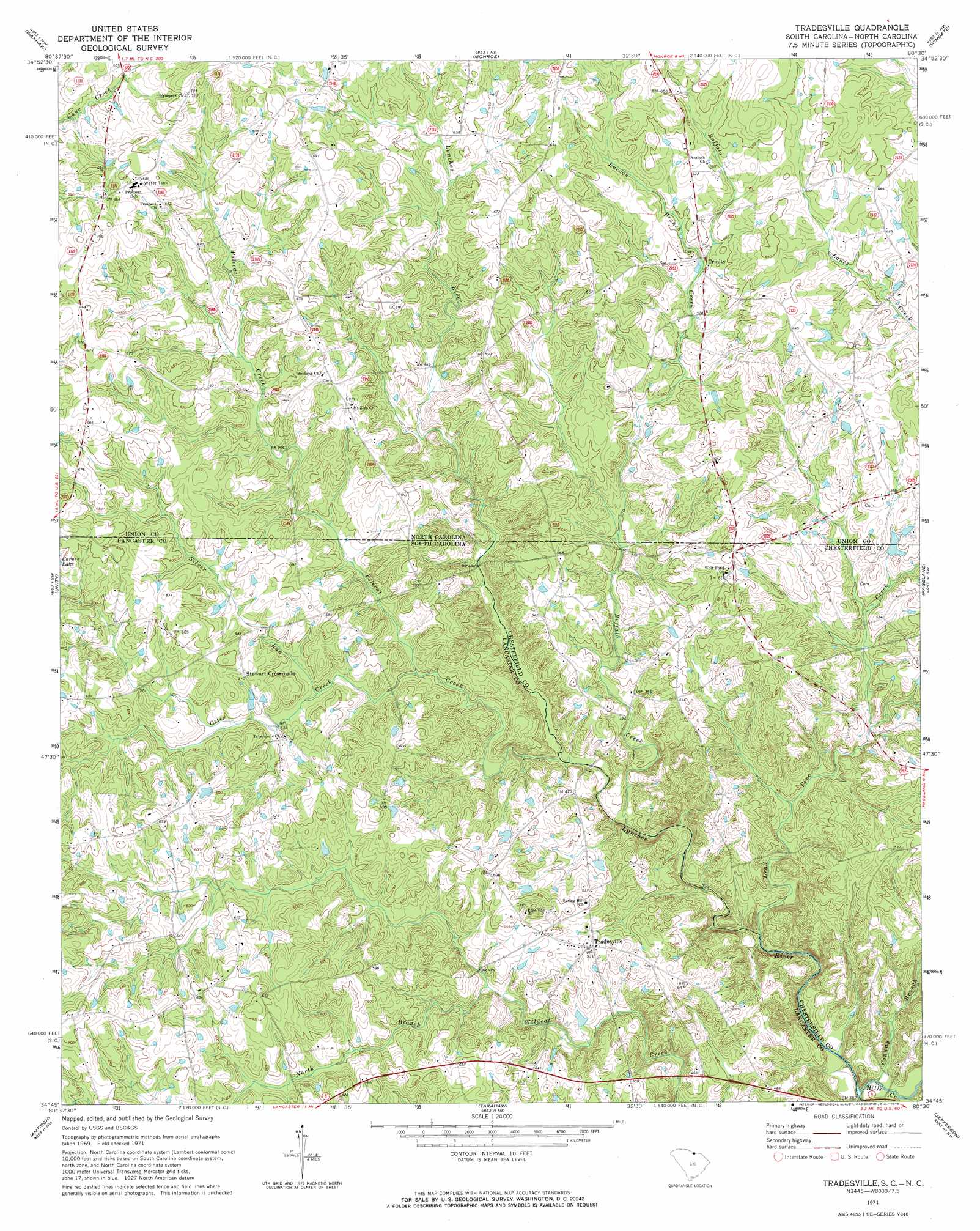
Tradesville Topo Map South Carolina
To zoom in, hover over the map of Tradesville
USGS Topo Quad 34080g5 - 1:24,000 scale
| Topo Map Name: | Tradesville |
| USGS Topo Quad ID: | 34080g5 |
| Print Size: | ca. 21 1/4" wide x 27" high |
| Southeast Coordinates: | 34.75° N latitude / 80.5° W longitude |
| Map Center Coordinates: | 34.8125° N latitude / 80.5625° W longitude |
| U.S. States: | SC, NC |
| Filename: | o34080g5.jpg |
| Download Map JPG Image: | Tradesville topo map 1:24,000 scale |
| Map Type: | Topographic |
| Topo Series: | 7.5´ |
| Map Scale: | 1:24,000 |
| Source of Map Images: | United States Geological Survey (USGS) |
| Alternate Map Versions: |
Tradesville SC 1971, updated 1973 Download PDF Buy paper map Tradesville SC 2011 Download PDF Buy paper map Tradesville SC 2014 Download PDF Buy paper map |
1:24,000 Topo Quads surrounding Tradesville
Weddington |
Matthews |
Bakers |
Watson |
Olive Branch |
Catawba Ne |
Waxhaw |
Monroe |
Wingate |
Marshville |
Van Wyck |
Unity |
Tradesville |
Pageland |
Hornsboro |
Lancaster |
Antioch |
Taxahaw |
Jefferson |
Jefferson Ne |
Lancaster Se |
Heath Springs |
Kershaw |
Mount Pisgah |
Angelus |
> Back to 34080e1 at 1:100,000 scale
> Back to 34080a1 at 1:250,000 scale
> Back to U.S. Topo Maps home
Tradesville topo map: Gazetteer
Tradesville: Crossings
Houghs ford elevation 107m 351′Tradesville: Dams
Perry Lake Dam elevation 190m 623′Tradesville: Populated Places
Stewart Crossroads elevation 176m 577′Tradesville elevation 159m 521′
Trinity elevation 176m 577′
Wolf Pond Cross Roads elevation 183m 600′
Tradesville: Reservoirs
Perry Lake elevation 190m 623′Tradesville: Streams
Buffalo Creek elevation 127m 416′Buffalo Creek elevation 130m 426′
Conway Branch elevation 106m 347′
Dead Pine Creek elevation 120m 393′
Hills Creek elevation 105m 344′
Otter Creek elevation 153m 501′
Polecat Creek elevation 134m 439′
Polecat Creek elevation 133m 436′
Racoon Branch elevation 174m 570′
Silver Run elevation 157m 515′
Tradesville digital topo map on disk
Buy this Tradesville topo map showing relief, roads, GPS coordinates and other geographical features, as a high-resolution digital map file on DVD:
South Carolina, Western North Carolina & Northeastern Georgia
Buy digital topo maps: South Carolina, Western North Carolina & Northeastern Georgia