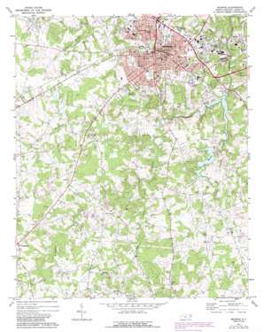
Monroe Topo Map North Carolina
To zoom in, hover over the map of Monroe
USGS Topo Quad 34080h5 - 1:24,000 scale
| Topo Map Name: | Monroe |
| USGS Topo Quad ID: | 34080h5 |
| Print Size: | ca. 21 1/4" wide x 27" high |
| Southeast Coordinates: | 34.875° N latitude / 80.5° W longitude |
| Map Center Coordinates: | 34.9375° N latitude / 80.5625° W longitude |
| U.S. State: | NC |
| Filename: | o34080h5.jpg |
| Download Map JPG Image: | Monroe topo map 1:24,000 scale |
| Map Type: | Topographic |
| Topo Series: | 7.5´ |
| Map Scale: | 1:24,000 |
| Source of Map Images: | United States Geological Survey (USGS) |
| Alternate Map Versions: |
Monroe NC 1971, updated 1973 Download PDF Buy paper map Monroe NC 1971, updated 1989 Download PDF Buy paper map Monroe NC 2010 Download PDF Buy paper map Monroe NC 2013 Download PDF Buy paper map Monroe NC 2016 Download PDF Buy paper map |
1:24,000 Topo Quads surrounding Monroe
> Back to 34080e1 at 1:100,000 scale
> Back to 34080a1 at 1:250,000 scale
> Back to U.S. Topo Maps home
Monroe topo map: Gazetteer
Monroe: Dams
Lake Lee Dam elevation 142m 465′Lake Monroe Dam elevation 167m 547′
Monroe: Parks
Creft Park elevation 174m 570′Dickerson Park elevation 174m 570′
Jaycee Park elevation 169m 554′
Sunset Park elevation 184m 603′
Sutton Park elevation 161m 528′
Walter Bickett Stadium elevation 187m 613′
Winchester Avenue Community Facility Center elevation 185m 606′
Monroe: Populated Places
Alton elevation 220m 721′Benton Heights elevation 187m 613′
Bramblewood elevation 183m 600′
Brookhaven elevation 154m 505′
Carmel Village elevation 191m 626′
Council Oaks elevation 177m 580′
Forest Hills elevation 194m 636′
Franklin Colony elevation 185m 606′
Heil Leah elevation 157m 515′
Hillcrest elevation 175m 574′
Keswick elevation 180m 590′
Kingswood elevation 192m 629′
Knollwood elevation 169m 554′
Lakeview Estates elevation 176m 577′
Lee Wood elevation 179m 587′
Monroe elevation 183m 600′
Northwood elevation 181m 593′
Oakland elevation 186m 610′
Park Place elevation 178m 583′
Ridgewood elevation 173m 567′
Rock Rest elevation 170m 557′
Roland Park elevation 180m 590′
Roughedge elevation 215m 705′
Sherwood Forest elevation 186m 610′
Southgate Estates elevation 187m 613′
Southwood Estates elevation 185m 606′
Stewart Park elevation 192m 629′
Sutton Park elevation 172m 564′
Timber Lake elevation 193m 633′
Welsh Heights elevation 185m 606′
White Oaks elevation 191m 626′
Monroe: Reservoirs
Lake Lee elevation 142m 465′Lake Monroe elevation 167m 547′
Monroe: Streams
Adams Branch elevation 163m 534′Bearskin Creek elevation 141m 462′
Beaverdam Creek elevation 192m 629′
Buck Branch elevation 152m 498′
Camp Branch elevation 176m 577′
Dry Fork elevation 174m 570′
Little Richardson Creek elevation 150m 492′
Monroe digital topo map on disk
Buy this Monroe topo map showing relief, roads, GPS coordinates and other geographical features, as a high-resolution digital map file on DVD:
South Carolina, Western North Carolina & Northeastern Georgia
Buy digital topo maps: South Carolina, Western North Carolina & Northeastern Georgia


