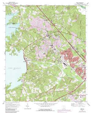
Irmo Topo Map South Carolina
To zoom in, hover over the map of Irmo
USGS Topo Quad 34081a2 - 1:24,000 scale
| Topo Map Name: | Irmo |
| USGS Topo Quad ID: | 34081a2 |
| Print Size: | ca. 21 1/4" wide x 27" high |
| Southeast Coordinates: | 34° N latitude / 81.125° W longitude |
| Map Center Coordinates: | 34.0625° N latitude / 81.1875° W longitude |
| U.S. State: | SC |
| Filename: | o34081a2.jpg |
| Download Map JPG Image: | Irmo topo map 1:24,000 scale |
| Map Type: | Topographic |
| Topo Series: | 7.5´ |
| Map Scale: | 1:24,000 |
| Source of Map Images: | United States Geological Survey (USGS) |
| Alternate Map Versions: |
Irmo SC 1946, updated 1968 Download PDF Buy paper map Irmo SC 1948 Download PDF Buy paper map Irmo SC 1971, updated 1973 Download PDF Buy paper map Irmo SC 1971, updated 1990 Download PDF Buy paper map Irmo SC 1971, updated 1990 Download PDF Buy paper map Irmo SC 2011 Download PDF Buy paper map Irmo SC 2014 Download PDF Buy paper map |
1:24,000 Topo Quads surrounding Irmo
> Back to 34081a1 at 1:100,000 scale
> Back to 34080a1 at 1:250,000 scale
> Back to U.S. Topo Maps home
Irmo topo map: Gazetteer
Irmo: Capes
Rocky Point elevation 113m 370′Irmo: Crossings
Interchange 101 elevation 101m 331′Interchange 102 elevation 91m 298′
Interchange 103 elevation 98m 321′
Interchange 104 elevation 84m 275′
Interchange 61 elevation 113m 370′
Irmo: Dams
Coldstream Pond Dam elevation 88m 288′Harbison New Town Lake A D-0057 Dam elevation 79m 259′
Lake Murray Dam elevation 97m 318′
Lake Quail Valley Dam D-1277 elevation 75m 246′
Saluda Dam elevation 82m 269′
South Carolina Noname 32080 D-0957 Dam elevation 62m 203′
South Carolina Noname 32088 Dam elevation 58m 190′
South Carolina Noname 32095 D-1705 Dam elevation 69m 226′
Whitehall Subdivision Complex Dam elevation 78m 255′
Irmo: Islands
Corley Island elevation 58m 190′Irmo: Parks
Harrison State Forest elevation 94m 308′Irmo: Populated Places
Ballentine elevation 137m 449′Ballentine Landing elevation 109m 357′
Bonnie Forest elevation 94m 308′
Challedon elevation 64m 209′
Challedon West elevation 86m 282′
Coatesworth elevation 102m 334′
Coldstream elevation 91m 298′
Dutch Village elevation 78m 255′
East Lake elevation 115m 377′
East Shore elevation 121m 396′
Friarsgate elevation 104m 341′
Gardendale elevation 57m 187′
Grenadier elevation 73m 239′
Hallmark elevation 60m 196′
Hillcreek elevation 107m 351′
Hollywood Point elevation 117m 383′
Hope Ferry Estates elevation 87m 285′
Irmo elevation 108m 354′
Landmark elevation 92m 301′
Laurel Meadows elevation 99m 324′
Leaphart elevation 57m 187′
Lost Creek elevation 68m 223′
Murray Forest elevation 117m 383′
Oak Creek elevation 83m 272′
Pineglen elevation 56m 183′
Raintree Acres elevation 67m 219′
Saint Andrews elevation 92m 301′
Selwood Shores elevation 120m 393′
Seven Oaks elevation 66m 216′
Shadow Brook elevation 72m 236′
Spring Lake elevation 86m 282′
The Forest elevation 101m 331′
Town and Country elevation 113m 370′
Varnarsdale elevation 111m 364′
Walden elevation 79m 259′
Whitehall elevation 70m 229′
Woodland Hills elevation 79m 259′
Yacht Cove elevation 119m 390′
Irmo: Post Offices
Ballentine Post Office elevation 134m 439′Irmo: Reservoirs
Corley Millpond elevation 62m 203′Lake Murray elevation 97m 318′
Lake Quail Valley elevation 75m 246′
Whitehall Lakes elevation 78m 255′
Irmo: Streams
Drafts Branch elevation 59m 193′Fourteenmile Creek elevation 56m 183′
Kinley Creek elevation 50m 164′
Koon Branch elevation 54m 177′
Lorick Branch elevation 54m 177′
Moccasin Branch elevation 67m 219′
Rawls Creek elevation 54m 177′
Swygert Branch elevation 54m 177′
Twelvemile Creek elevation 55m 180′
Yost Creek elevation 61m 200′
Irmo: Summits
Nursery Hill elevation 87m 285′Irmo digital topo map on disk
Buy this Irmo topo map showing relief, roads, GPS coordinates and other geographical features, as a high-resolution digital map file on DVD:
South Carolina, Western North Carolina & Northeastern Georgia
Buy digital topo maps: South Carolina, Western North Carolina & Northeastern Georgia


