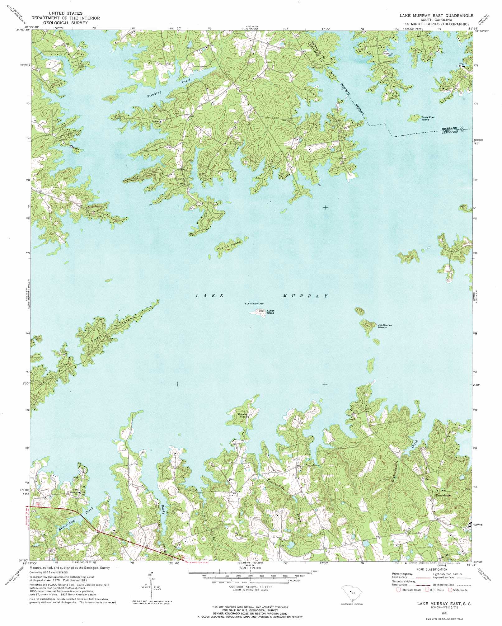
Lake Murray East Topo Map South Carolina
To zoom in, hover over the map of Lake Murray East
USGS Topo Quad 34081a3 - 1:24,000 scale
| Topo Map Name: | Lake Murray East |
| USGS Topo Quad ID: | 34081a3 |
| Print Size: | ca. 21 1/4" wide x 27" high |
| Southeast Coordinates: | 34° N latitude / 81.25° W longitude |
| Map Center Coordinates: | 34.0625° N latitude / 81.3125° W longitude |
| U.S. State: | SC |
| Filename: | o34081a3.jpg |
| Download Map JPG Image: | Lake Murray East topo map 1:24,000 scale |
| Map Type: | Topographic |
| Topo Series: | 7.5´ |
| Map Scale: | 1:24,000 |
| Source of Map Images: | United States Geological Survey (USGS) |
| Alternate Map Versions: |
Lake Murray East SC 1971, updated 1973 Download PDF Buy paper map Lake Murray East SC 2011 Download PDF Buy paper map Lake Murray East SC 2014 Download PDF Buy paper map |
1:24,000 Topo Quads surrounding Lake Murray East
Newberry East |
Pomaria |
Jenkinsville |
Rion |
Winnsboro Mills |
Prosperity |
Little Mountain |
Chapin |
Richtex |
Irmo Ne |
Delmar |
Lake Murray West |
Lake Murray East |
Irmo |
Columbia North |
Batesburg |
Gilbert |
Barr Lake |
Lexington |
Southwest Columbia |
Monetta |
Steedman |
Fairview Crossroads |
Pelion East |
Gaston |
> Back to 34081a1 at 1:100,000 scale
> Back to 34080a1 at 1:250,000 scale
> Back to U.S. Topo Maps home
Lake Murray East topo map: Gazetteer
Lake Murray East: Dams
South Carolina Noname 32087 D-1714 Dam elevation 119m 390′Lake Murray East: Islands
Bundrick Island elevation 118m 387′Counts Island elevation 116m 380′
Jim Spence Islands elevation 121m 396′
Lunch Island elevation 117m 383′
Shull Island elevation 118m 387′
Susie Ebert Island elevation 113m 370′
Lake Murray East: Populated Places
Dutchman Shores elevation 124m 406′Hallmark Shores elevation 128m 419′
Harbor Side elevation 122m 400′
Lake Point elevation 116m 380′
Lands End elevation 123m 403′
Peters elevation 164m 538′
Pine Point elevation 118m 387′
Providence elevation 153m 501′
Rollingwood elevation 161m 528′
Shady Acres elevation 113m 370′
Lake Murray East: Reservoirs
Bickleys Pond elevation 119m 390′Lake Murray East: Streams
Beaverdam Creek elevation 110m 360′Beech Creek elevation 112m 367′
Clemons Branch elevation 111m 364′
Eighteenmile Creek elevation 110m 360′
Rocky Creek elevation 110m 360′
Stinking Creek elevation 110m 360′
Twentymile Creek elevation 112m 367′
Lake Murray East digital topo map on disk
Buy this Lake Murray East topo map showing relief, roads, GPS coordinates and other geographical features, as a high-resolution digital map file on DVD:
South Carolina, Western North Carolina & Northeastern Georgia
Buy digital topo maps: South Carolina, Western North Carolina & Northeastern Georgia