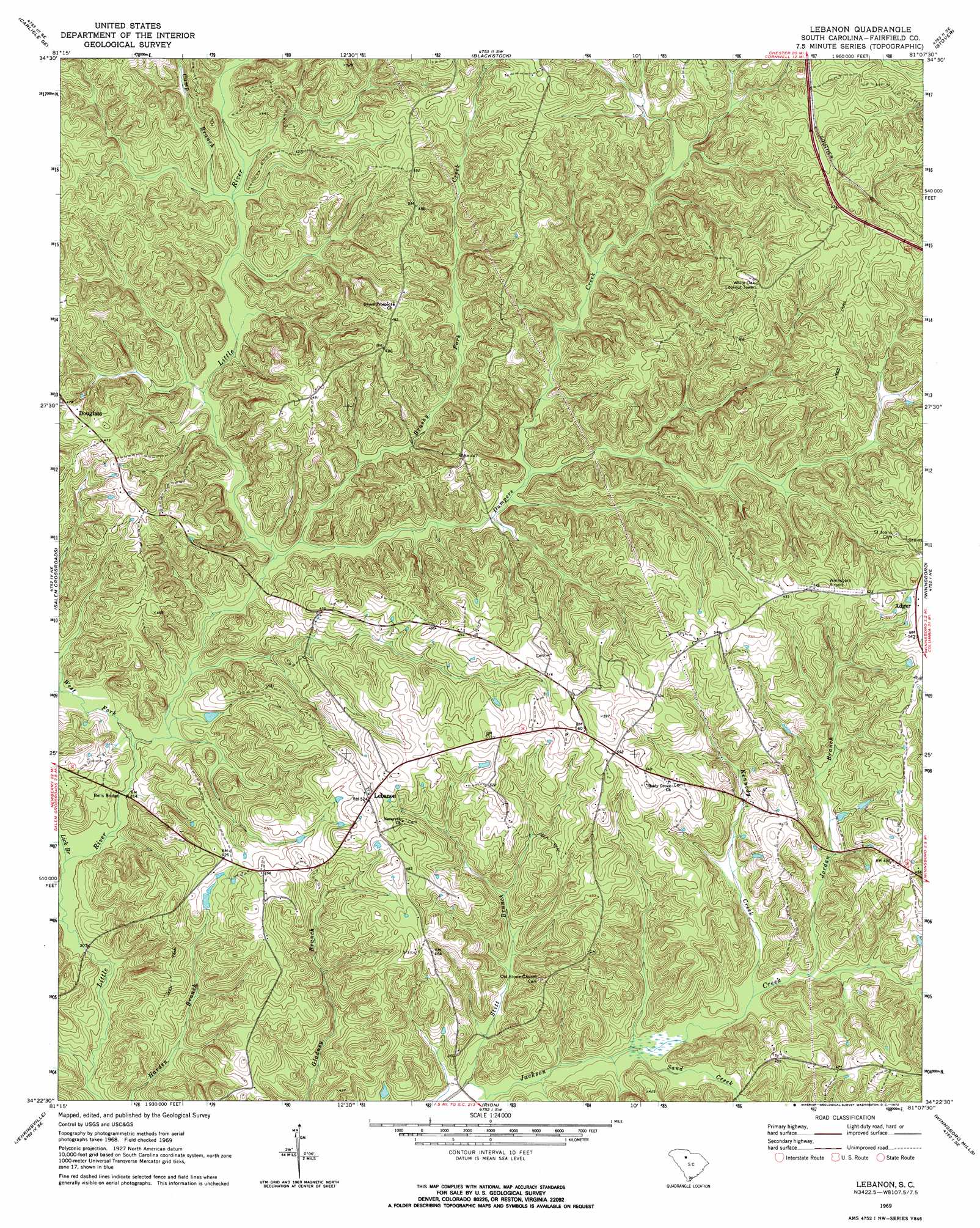
Lebanon Topo Map South Carolina
To zoom in, hover over the map of Lebanon
USGS Topo Quad 34081d2 - 1:24,000 scale
| Topo Map Name: | Lebanon |
| USGS Topo Quad ID: | 34081d2 |
| Print Size: | ca. 21 1/4" wide x 27" high |
| Southeast Coordinates: | 34.375° N latitude / 81.125° W longitude |
| Map Center Coordinates: | 34.4375° N latitude / 81.1875° W longitude |
| U.S. State: | SC |
| Filename: | o34081d2.jpg |
| Download Map JPG Image: | Lebanon topo map 1:24,000 scale |
| Map Type: | Topographic |
| Topo Series: | 7.5´ |
| Map Scale: | 1:24,000 |
| Source of Map Images: | United States Geological Survey (USGS) |
| Alternate Map Versions: |
Lebanon SC 1969, updated 1972 Download PDF Buy paper map Lebanon SC 2011 Download PDF Buy paper map Lebanon SC 2014 Download PDF Buy paper map |
1:24,000 Topo Quads surrounding Lebanon
Leeds |
Baton Rouge |
Chester |
Richburg |
Fort Lawn |
Carlisle |
Carlisle Se |
Blackstock |
Stover |
Great Falls |
Blair |
Salem Crossroads |
Lebanon |
Winnsboro |
Flint Hill |
Pomaria |
Jenkinsville |
Rion |
Winnsboro Mills |
Ridgeway |
Little Mountain |
Chapin |
Richtex |
Irmo Ne |
Blythewood |
> Back to 34081a1 at 1:100,000 scale
> Back to 34080a1 at 1:250,000 scale
> Back to U.S. Topo Maps home
Lebanon topo map: Gazetteer
Lebanon: Bridges
Bells Bridge elevation 91m 298′Lebanon: Dams
South Carolina Noname 20019 D-0520 Dam elevation 133m 436′Lebanon: Populated Places
Adger elevation 159m 521′Douglass elevation 144m 472′
Lebanon elevation 158m 518′
Lebanon: Streams
Brushy Fork Creek elevation 95m 311′Camp Branch elevation 104m 341′
Dumpers Creek elevation 95m 311′
Jordan Branch elevation 103m 337′
Kennedy Creek elevation 102m 334′
Lick Branch elevation 90m 295′
Mobley Creek elevation 104m 341′
Opossum Branch elevation 93m 305′
Sand Creek elevation 97m 318′
Stitt Branch elevation 91m 298′
West Fork Little River elevation 91m 298′
Lebanon digital topo map on disk
Buy this Lebanon topo map showing relief, roads, GPS coordinates and other geographical features, as a high-resolution digital map file on DVD:
South Carolina, Western North Carolina & Northeastern Georgia
Buy digital topo maps: South Carolina, Western North Carolina & Northeastern Georgia