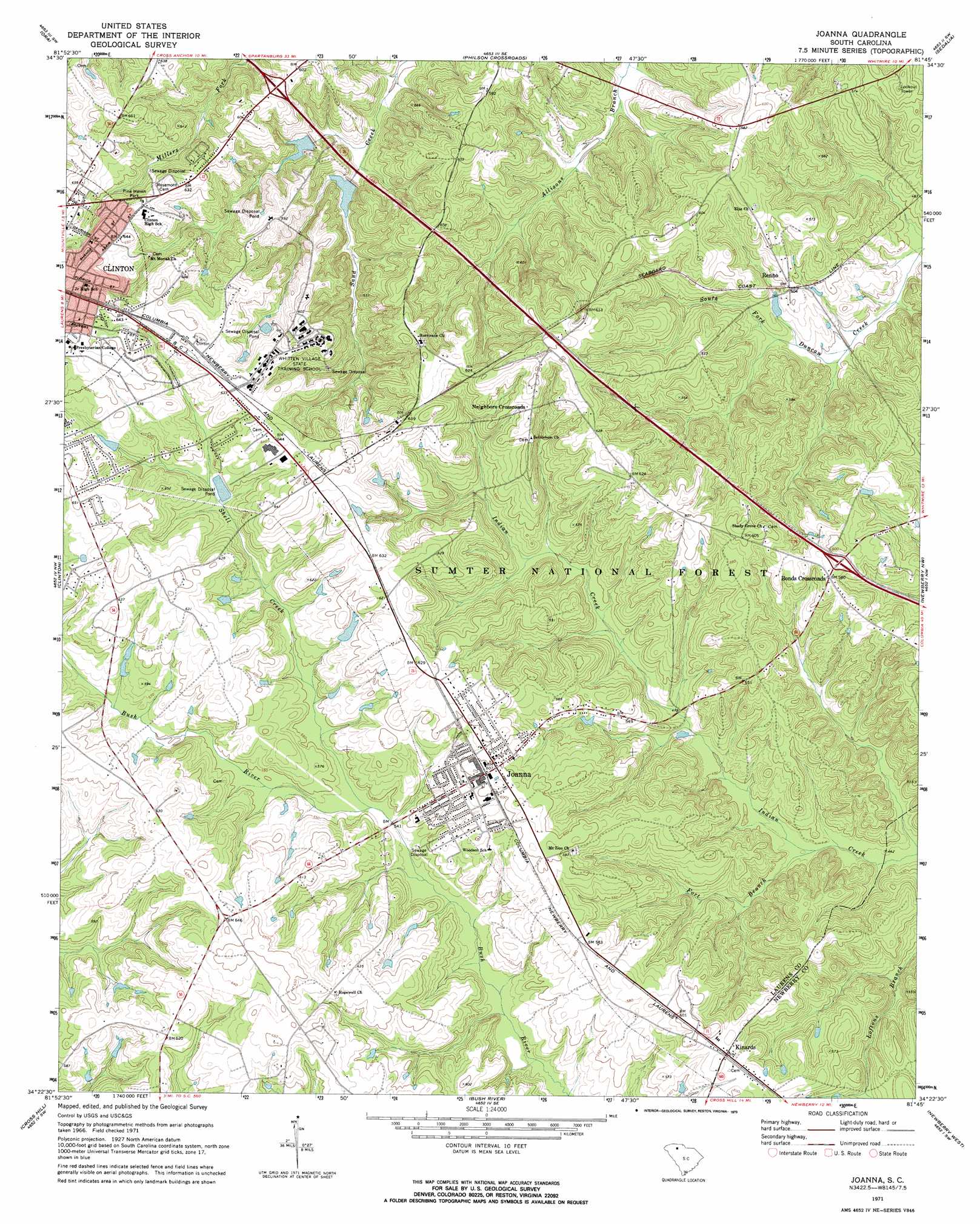
Joanna Topo Map South Carolina
To zoom in, hover over the map of Joanna
USGS Topo Quad 34081d7 - 1:24,000 scale
| Topo Map Name: | Joanna |
| USGS Topo Quad ID: | 34081d7 |
| Print Size: | ca. 21 1/4" wide x 27" high |
| Southeast Coordinates: | 34.375° N latitude / 81.75° W longitude |
| Map Center Coordinates: | 34.4375° N latitude / 81.8125° W longitude |
| U.S. State: | SC |
| Filename: | o34081d7.jpg |
| Download Map JPG Image: | Joanna topo map 1:24,000 scale |
| Map Type: | Topographic |
| Topo Series: | 7.5´ |
| Map Scale: | 1:24,000 |
| Source of Map Images: | United States Geological Survey (USGS) |
| Alternate Map Versions: |
Joanna SC 1971, updated 1973 Download PDF Buy paper map Joanna SC 2011 Download PDF Buy paper map Joanna SC 2014 Download PDF Buy paper map |
| FStopo: | US Forest Service topo Joanna is available: Download FStopo PDF Download FStopo TIF |
1:24,000 Topo Quads surrounding Joanna
Woodruff |
Enoree |
Cross Anchor |
Union West |
Union East |
Laurens North |
Ora |
Philson Crossroads |
Sedalia |
Whitmire North |
Laurens South |
Clinton |
Joanna |
Newberry Nw |
Whitmire South |
Waterloo |
Cross Hill |
Bush River |
Newberry West |
Newberry East |
Ninety Six |
Dyson |
Chappells |
Silverstreet |
Prosperity |
> Back to 34081a1 at 1:100,000 scale
> Back to 34080a1 at 1:250,000 scale
> Back to U.S. Topo Maps home
Joanna topo map: Gazetteer
Joanna: Crossings
Interchange 54 elevation 173m 567′Interchange 60 elevation 177m 580′
Joanna: Dams
Clinton Industrial Park Dam D-3000 elevation 178m 583′Copeland Pond Dam D-3006 elevation 146m 479′
Duncan Creek WCD Dam Number Eight elevation 148m 485′
Duncan Creek WCD Dam Number Seven D-3005 elevation 149m 488′
Heath Copeland Pond Dam D-3001 elevation 187m 613′
Sarah Copeland Pond Dam D-2998 elevation 187m 613′
Joanna: Parks
Pine Haven Park elevation 192m 629′Joanna: Populated Places
Bonds Crossroads elevation 188m 616′Dover (historical) elevation 192m 629′
Joanna elevation 183m 600′
Kinards elevation 180m 590′
Neighbors Crossroads elevation 187m 613′
Renno elevation 153m 501′
Smallwood elevation 201m 659′
Joanna: Reservoirs
Copeland Pond elevation 146m 479′Duncan Creek WCD Lake Number Eight elevation 148m 485′
Duncan Creek WCD Lake Number Seven elevation 149m 488′
Heath Copeland Pond elevation 187m 613′
Industrial Waste Pond elevation 178m 583′
Sarah Copeland Pond elevation 187m 613′
Joanna: Streams
Fort Branch elevation 133m 436′Shell Creek elevation 164m 538′
Stillhouse Branch elevation 145m 475′
Joanna digital topo map on disk
Buy this Joanna topo map showing relief, roads, GPS coordinates and other geographical features, as a high-resolution digital map file on DVD:
South Carolina, Western North Carolina & Northeastern Georgia
Buy digital topo maps: South Carolina, Western North Carolina & Northeastern Georgia