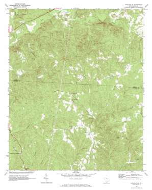
Carlisle Se Topo Map South Carolina
To zoom in, hover over the map of Carlisle Se
USGS Topo Quad 34081e3 - 1:24,000 scale
| Topo Map Name: | Carlisle Se |
| USGS Topo Quad ID: | 34081e3 |
| Print Size: | ca. 21 1/4" wide x 27" high |
| Southeast Coordinates: | 34.5° N latitude / 81.25° W longitude |
| Map Center Coordinates: | 34.5625° N latitude / 81.3125° W longitude |
| U.S. State: | SC |
| Filename: | o34081e3.jpg |
| Download Map JPG Image: | Carlisle Se topo map 1:24,000 scale |
| Map Type: | Topographic |
| Topo Series: | 7.5´ |
| Map Scale: | 1:24,000 |
| Source of Map Images: | United States Geological Survey (USGS) |
| Alternate Map Versions: |
Carlisle SE SC 1969, updated 1973 Download PDF Buy paper map Carlisle SE SC 2011 Download PDF Buy paper map Carlisle SE SC 2014 Download PDF Buy paper map |
| FStopo: | US Forest Service topo Carlisle SE is available: Download FStopo PDF Download FStopo TIF |
1:24,000 Topo Quads surrounding Carlisle Se
> Back to 34081e1 at 1:100,000 scale
> Back to 34080a1 at 1:250,000 scale
> Back to U.S. Topo Maps home
Carlisle Se topo map: Gazetteer
Carlisle Se: Parks
Featerville Academy Historic District elevation 144m 472′Carlisle Se: Populated Places
Feasterville elevation 145m 475′Carlisle Se: Streams
Coon Creek elevation 99m 324′Little Sandy River elevation 97m 318′
Mobley Creek elevation 112m 367′
Spring Branch elevation 133m 436′
Weir Creek elevation 124m 406′
Carlisle Se digital topo map on disk
Buy this Carlisle Se topo map showing relief, roads, GPS coordinates and other geographical features, as a high-resolution digital map file on DVD:
South Carolina, Western North Carolina & Northeastern Georgia
Buy digital topo maps: South Carolina, Western North Carolina & Northeastern Georgia


