Cross Anchor Topo Map South Carolina
To zoom in, hover over the map of Cross Anchor
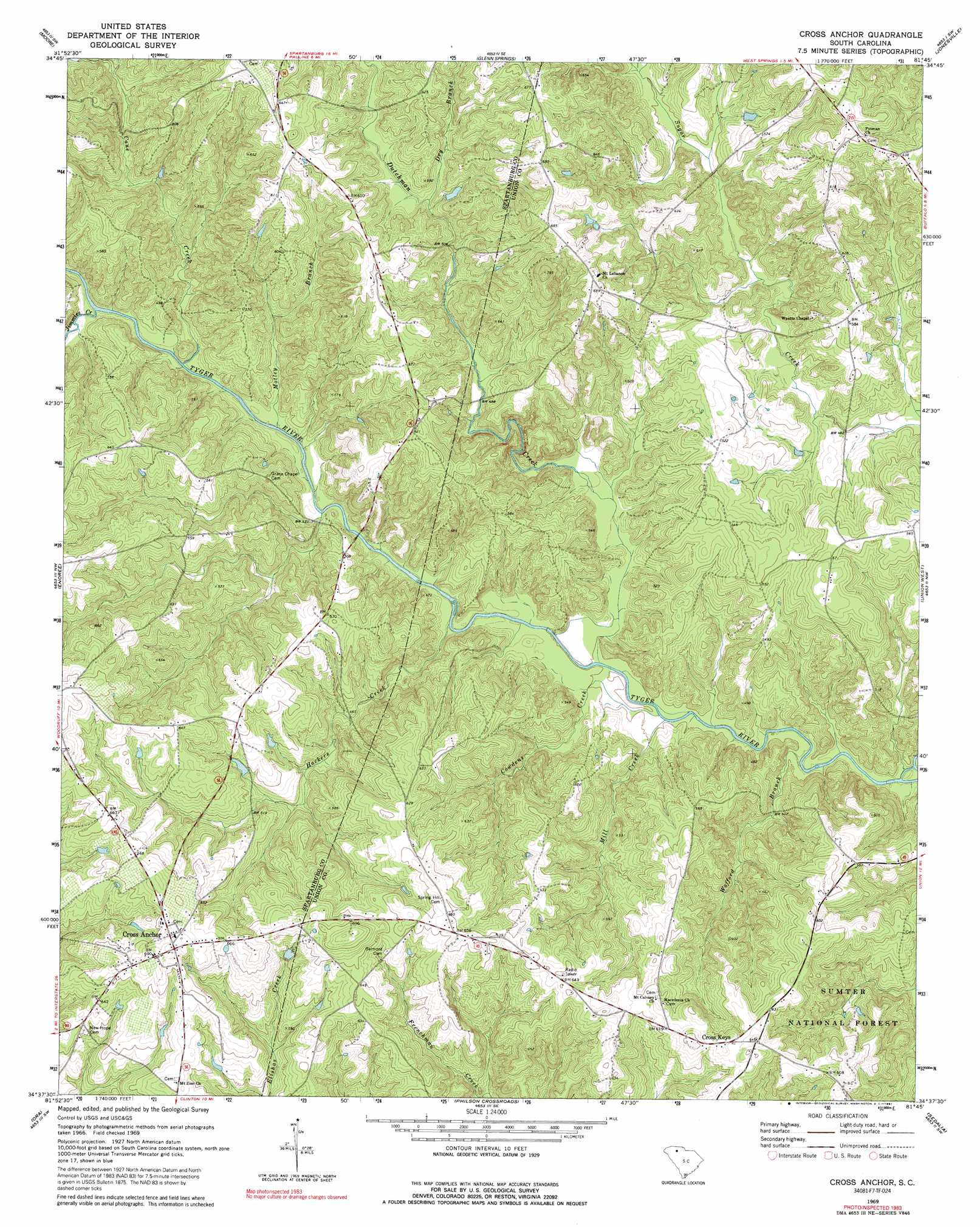
USGS Topo Quad 34081f7 - 1:24,000 scale
| Topo Map Name: | Cross Anchor |
| USGS Topo Quad ID: | 34081f7 |
| Print Size: | ca. 21 1/4" wide x 27" high |
| Southeast Coordinates: | 34.625° N latitude / 81.75° W longitude |
| Map Center Coordinates: | 34.6875° N latitude / 81.8125° W longitude |
| U.S. State: | SC |
| Filename: | o34081f7.jpg |
| Download Map JPG Image: | Cross Anchor topo map 1:24,000 scale |
| Map Type: | Topographic |
| Topo Series: | 7.5´ |
| Map Scale: | 1:24,000 |
| Source of Map Images: | United States Geological Survey (USGS) |
| Alternate Map Versions: |
Cross Anchor SC 1969, updated 1972 Download PDF Buy paper map Cross Anchor SC 1969, updated 1973 Download PDF Buy paper map Cross Anchor SC 1969, updated 1991 Download PDF Buy paper map Cross Anchor SC 2011 Download PDF Buy paper map Cross Anchor SC 2014 Download PDF Buy paper map |
| FStopo: | US Forest Service topo Cross Anchor is available: Download FStopo PDF Download FStopo TIF |
1:24,000 Topo Quads surrounding Cross Anchor
Wellford |
Spartanburg |
Pacolet |
Pacolet Mills |
Wilkinsville |
Reidville |
Moore |
Glenn Springs |
Jonesville |
Kelton |
Woodruff |
Enoree |
Cross Anchor |
Union West |
Union East |
Laurens North |
Ora |
Philson Crossroads |
Sedalia |
Whitmire North |
Laurens South |
Clinton |
Joanna |
Newberry Nw |
Whitmire South |
> Back to 34081e1 at 1:100,000 scale
> Back to 34080a1 at 1:250,000 scale
> Back to U.S. Topo Maps home
Cross Anchor topo map: Gazetteer
Cross Anchor: Areas
Meadow Woods elevation 166m 544′Cross Anchor: Bridges
Burnt Factory Bridge elevation 126m 413′Vernon Bridge elevation 146m 479′
Cross Anchor: Crossings
Blackstocks Ford elevation 122m 400′Cross Anchor: Dams
D Correctional Pond Dam D-3391 elevation 130m 426′G H Southerland Pond Dam D-3392 elevation 182m 597′
Cross Anchor: Populated Places
Black Jack Valley (historical) elevation 152m 498′Colerain elevation 203m 666′
Cross Anchor elevation 204m 669′
Cross Keys elevation 192m 629′
Dutchman elevation 197m 646′
Wildcat (historical) elevation 197m 646′
Cross Anchor: Streams
Cane Creek elevation 129m 423′Cowdens Creek elevation 120m 393′
Dry Branch elevation 154m 505′
Dutchman Creek elevation 121m 396′
Hackers Creek elevation 123m 403′
Jimmies Creek elevation 129m 423′
Mill Creek elevation 120m 393′
Motley Branch elevation 126m 413′
Trail Branch elevation 151m 495′
Wofford Branch elevation 118m 387′
Cross Anchor: Summits
Beddington Mountain elevation 242m 793′Cross Anchor digital topo map on disk
Buy this Cross Anchor topo map showing relief, roads, GPS coordinates and other geographical features, as a high-resolution digital map file on DVD:
South Carolina, Western North Carolina & Northeastern Georgia
Buy digital topo maps: South Carolina, Western North Carolina & Northeastern Georgia