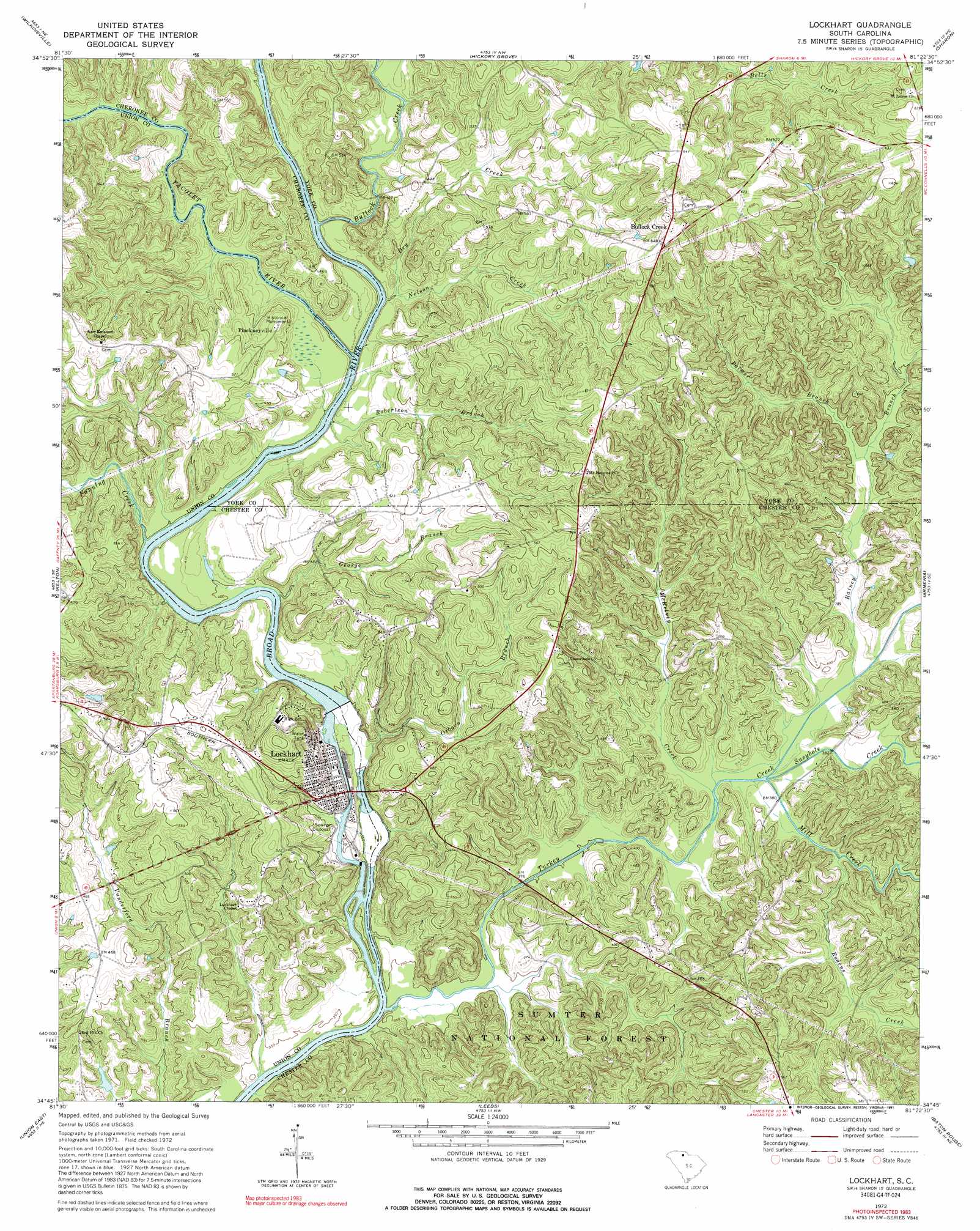
Lockhart Topo Map South Carolina
To zoom in, hover over the map of Lockhart
USGS Topo Quad 34081g4 - 1:24,000 scale
| Topo Map Name: | Lockhart |
| USGS Topo Quad ID: | 34081g4 |
| Print Size: | ca. 21 1/4" wide x 27" high |
| Southeast Coordinates: | 34.75° N latitude / 81.375° W longitude |
| Map Center Coordinates: | 34.8125° N latitude / 81.4375° W longitude |
| U.S. State: | SC |
| Filename: | o34081g4.jpg |
| Download Map JPG Image: | Lockhart topo map 1:24,000 scale |
| Map Type: | Topographic |
| Topo Series: | 7.5´ |
| Map Scale: | 1:24,000 |
| Source of Map Images: | United States Geological Survey (USGS) |
| Alternate Map Versions: |
Lockhart SC 1972, updated 1975 Download PDF Buy paper map Lockhart SC 1972, updated 1991 Download PDF Buy paper map Lockhart SC 2011 Download PDF Buy paper map Lockhart SC 2014 Download PDF Buy paper map |
| FStopo: | US Forest Service topo Lockhart is available: Download FStopo PDF Download FStopo TIF |
1:24,000 Topo Quads surrounding Lockhart
Gaffney |
Blacksburg South |
Kings Creek |
Filbert |
Clover |
Pacolet Mills |
Wilkinsville |
Hickory Grove |
Sharon |
Tirzah |
Jonesville |
Kelton |
Lockhart |
Armenia |
Lowrys |
Union West |
Union East |
Leeds |
Baton Rouge |
Chester |
Sedalia |
Whitmire North |
Carlisle |
Carlisle Se |
Blackstock |
> Back to 34081e1 at 1:100,000 scale
> Back to 34080a1 at 1:250,000 scale
> Back to U.S. Topo Maps home
Lockhart topo map: Gazetteer
Lockhart: Bars
Lockhart Lower Shoals elevation 101m 331′Lockharts Upper Shoals elevation 120m 393′
Lockhart: Canals
Lockharts Canala elevation 119m 390′Lockhart: Crossings
Loves Ford elevation 102m 334′Pinckney Ferry (historical) elevation 120m 393′
Thompson Ferry (historical) elevation 120m 393′
Lockhart: Dams
Cudds Pond Dam D-2158 elevation 115m 377′Lockhart Dam elevation 119m 390′
Lockhart: Islands
Goods Island (historical) elevation 120m 393′Lockhart: Populated Places
Bullock Creek elevation 204m 669′Cabal elevation 163m 534′
Cotton (historical) elevation 179m 587′
Gould (historical) elevation 146m 479′
Lockhart elevation 138m 452′
No Mans Land (historical) elevation 159m 521′
Pinckney elevation 175m 574′
Pinckneyville elevation 150m 492′
Red Hill elevation 135m 442′
Lockhart: Reservoirs
Cudds Pond elevation 115m 377′Lockhart Reservoir elevation 119m 390′
Lockhart: Streams
Bullock Creek elevation 121m 396′Dry Creek elevation 123m 403′
Fanning Creek elevation 120m 393′
George Branch elevation 120m 393′
McKelvey Creek elevation 110m 360′
Mill Creek elevation 111m 364′
Nelson Creek elevation 123m 403′
Osborn Branch elevation 110m 360′
Pacolet River elevation 120m 393′
Palmer Branch elevation 119m 390′
Rainey Branch elevation 112m 367′
Robertson Branch elevation 120m 393′
Rodens Creek elevation 116m 380′
Susybole Creek elevation 111m 364′
Turkey Creek elevation 102m 334′
Lockhart digital topo map on disk
Buy this Lockhart topo map showing relief, roads, GPS coordinates and other geographical features, as a high-resolution digital map file on DVD:
South Carolina, Western North Carolina & Northeastern Georgia
Buy digital topo maps: South Carolina, Western North Carolina & Northeastern Georgia