Kelton Topo Map South Carolina
To zoom in, hover over the map of Kelton
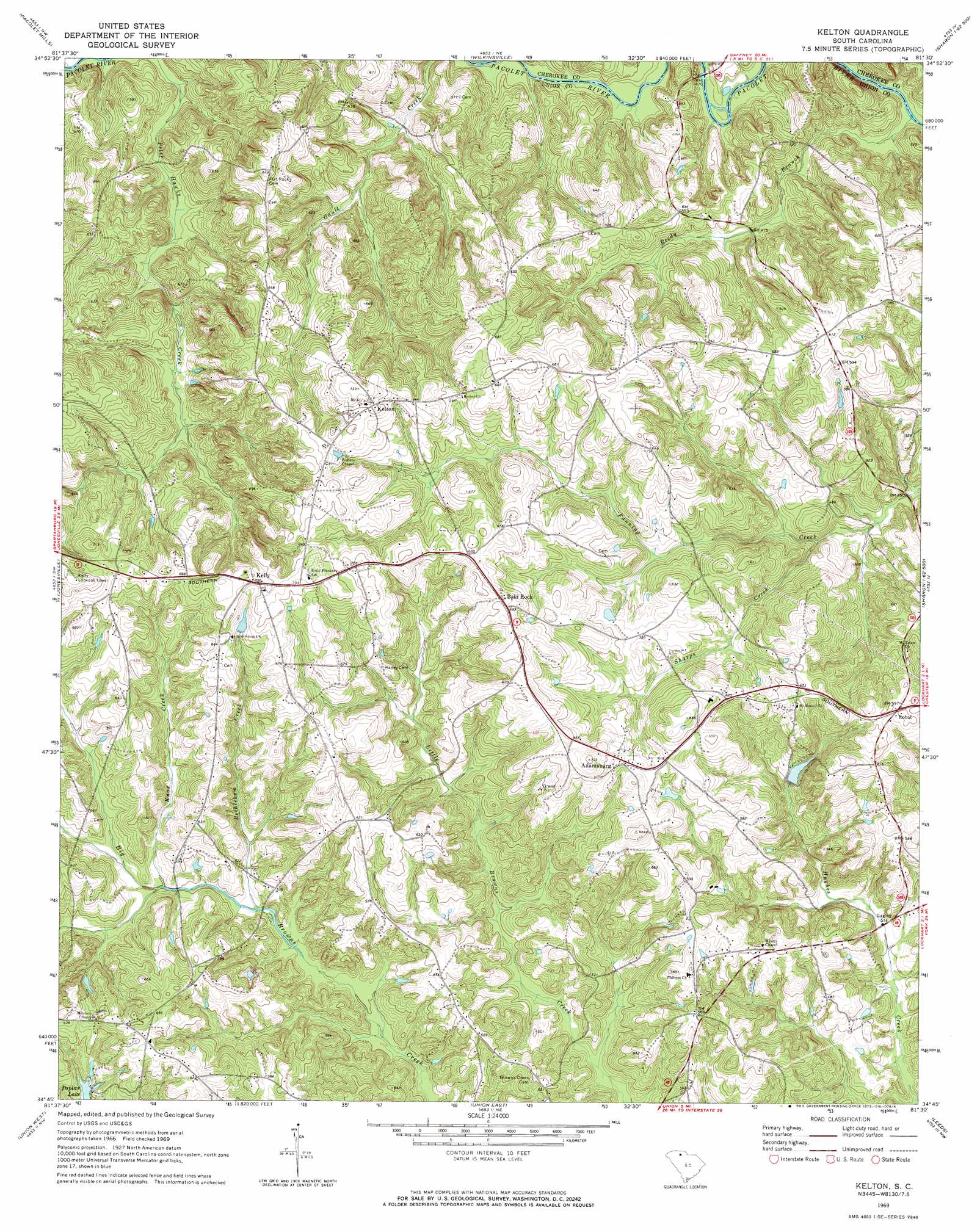
USGS Topo Quad 34081g5 - 1:24,000 scale
| Topo Map Name: | Kelton |
| USGS Topo Quad ID: | 34081g5 |
| Print Size: | ca. 21 1/4" wide x 27" high |
| Southeast Coordinates: | 34.75° N latitude / 81.5° W longitude |
| Map Center Coordinates: | 34.8125° N latitude / 81.5625° W longitude |
| U.S. State: | SC |
| Filename: | o34081g5.jpg |
| Download Map JPG Image: | Kelton topo map 1:24,000 scale |
| Map Type: | Topographic |
| Topo Series: | 7.5´ |
| Map Scale: | 1:24,000 |
| Source of Map Images: | United States Geological Survey (USGS) |
| Alternate Map Versions: |
Kelton SC 1969, updated 1973 Download PDF Buy paper map Kelton SC 2011 Download PDF Buy paper map Kelton SC 2014 Download PDF Buy paper map |
1:24,000 Topo Quads surrounding Kelton
Cowpens |
Gaffney |
Blacksburg South |
Kings Creek |
Filbert |
Pacolet |
Pacolet Mills |
Wilkinsville |
Hickory Grove |
Sharon |
Glenn Springs |
Jonesville |
Kelton |
Lockhart |
Armenia |
Cross Anchor |
Union West |
Union East |
Leeds |
Baton Rouge |
Philson Crossroads |
Sedalia |
Whitmire North |
Carlisle |
Carlisle Se |
> Back to 34081e1 at 1:100,000 scale
> Back to 34080a1 at 1:250,000 scale
> Back to U.S. Topo Maps home
Kelton topo map: Gazetteer
Kelton: Bars
Skull Shoals elevation 132m 433′Kelton: Dams
Adams Lake Dam D-2153 elevation 155m 508′Browns Creek Watershed Number Two D-2163 Dam elevation 135m 442′
Lake John D Long Dam D-2162 elevation 125m 410′
Poplar Lake Dam D-2152 elevation 166m 544′
Kelton: Populated Places
Adamsburg elevation 190m 623′Bailey Town (historical) elevation 178m 583′
Flat Rock (historical) elevation 205m 672′
Humphriesville (historical) elevation 196m 643′
Kelly elevation 214m 702′
Kelton elevation 215m 705′
Pine Tree (historical) elevation 189m 620′
Robat elevation 182m 597′
Simmon Tree (historical) elevation 177m 580′
Kelton: Reservoirs
Adams Lake elevation 155m 508′Lake John D Long elevation 125m 410′
Poplar Lake elevation 164m 538′
Kelton: Streams
Addis Branch elevation 157m 515′Bethlehem Creek elevation 146m 479′
Knox Creek elevation 152m 498′
Reedy Branch elevation 126m 413′
Sharps Creek elevation 137m 449′
Kelton digital topo map on disk
Buy this Kelton topo map showing relief, roads, GPS coordinates and other geographical features, as a high-resolution digital map file on DVD:
South Carolina, Western North Carolina & Northeastern Georgia
Buy digital topo maps: South Carolina, Western North Carolina & Northeastern Georgia