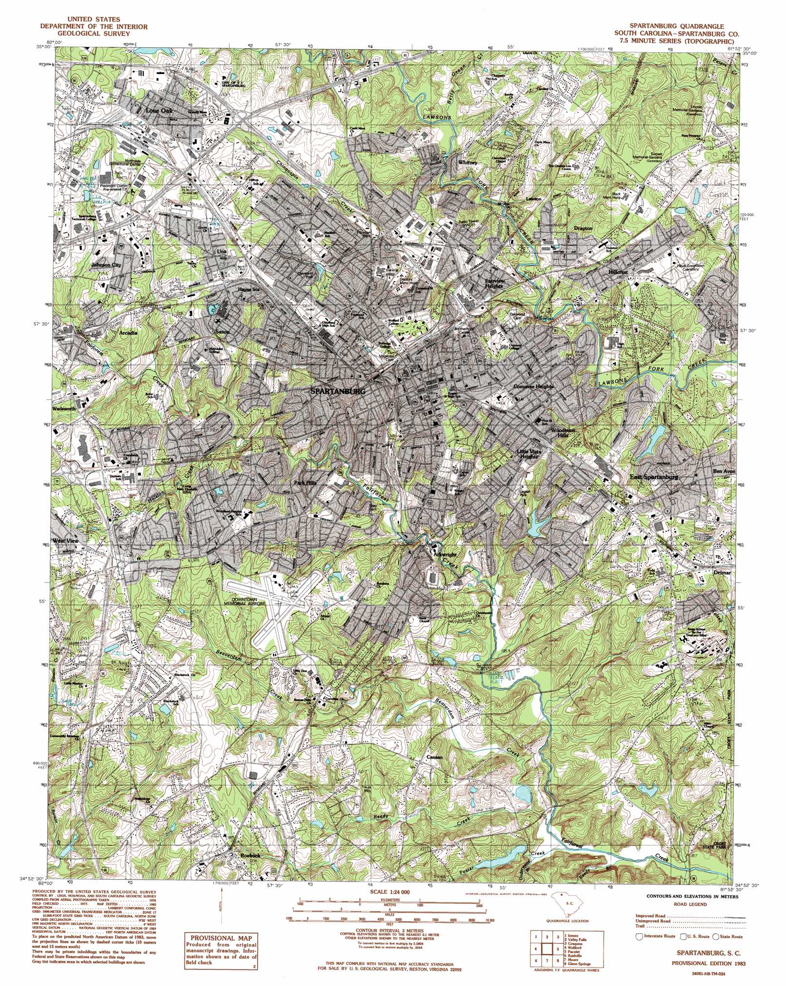
Spartanburg Topo Map South Carolina
To zoom in, hover over the map of Spartanburg
USGS Topo Quad 34081h8 - 1:24,000 scale
| Topo Map Name: | Spartanburg |
| USGS Topo Quad ID: | 34081h8 |
| Print Size: | ca. 21 1/4" wide x 27" high |
| Southeast Coordinates: | 34.875° N latitude / 81.875° W longitude |
| Map Center Coordinates: | 34.9375° N latitude / 81.9375° W longitude |
| U.S. State: | SC |
| Filename: | o34081h8.jpg |
| Download Map JPG Image: | Spartanburg topo map 1:24,000 scale |
| Map Type: | Topographic |
| Topo Series: | 7.5´ |
| Map Scale: | 1:24,000 |
| Source of Map Images: | United States Geological Survey (USGS) |
| Alternate Map Versions: |
Spartanburg SC 1949 Download PDF Buy paper map Spartanburg SC 1949 Download PDF Buy paper map Spartanburg SC 1949, updated 1977 Download PDF Buy paper map Spartanburg SC 1983, updated 1983 Download PDF Buy paper map Spartanburg SC 2011 Download PDF Buy paper map Spartanburg SC 2014 Download PDF Buy paper map |
1:24,000 Topo Quads surrounding Spartanburg
Landrum |
Fingerville West |
Fingerville East |
Chesnee |
Boiling Springs South |
Campobello |
Inman |
Valley Falls |
Cowpens |
Gaffney |
Greer |
Wellford |
Spartanburg |
Pacolet |
Pacolet Mills |
Pelham |
Reidville |
Moore |
Glenn Springs |
Jonesville |
Fountain Inn |
Woodruff |
Enoree |
Cross Anchor |
Union West |
> Back to 34081e1 at 1:100,000 scale
> Back to 34080a1 at 1:250,000 scale
> Back to U.S. Topo Maps home
Spartanburg topo map: Gazetteer
Spartanburg: Airports
Milliken and Company Heliport elevation 256m 839′Spartanburg Downtown Memorial Airport elevation 241m 790′
Spartanburg: Crossings
Interchange 21 elevation 253m 830′Interchange 22 elevation 253m 830′
Interchange 22 elevation 255m 836′
Interchange 23 elevation 266m 872′
Interchange 24 elevation 239m 784′
Interchange 25 elevation 225m 738′
Interchange 71 elevation 255m 836′
Interchange 72 elevation 272m 892′
Interchange 73 elevation 275m 902′
Interchange 75 elevation 238m 780′
Spartanburg: Dams
Cleveland Park Lake Dam D-3352 elevation 236m 774′J H Page Lake Dam D-2760 elevation 195m 639′
L Cornwell Pond Dam D-3362 elevation 221m 725′
Park Lake Dam D-3361 elevation 230m 754′
South Carolina Noname 42014 D-3356 Dam elevation 187m 613′
South Carolina Noname 42018 D-3355 Dam elevation 196m 643′
South Carolina Noname 42022 D-3366 Dam elevation 193m 633′
South Carolina Noname 42028 Dam elevation 211m 692′
Spartanburg: Parks
Carlisle Park elevation 229m 751′Cleveland Park elevation 239m 784′
Converse College Historic District elevation 238m 780′
Duncan Park elevation 222m 728′
Fairfield Park elevation 247m 810′
Hampton Heights Historic District elevation 233m 764′
Legion Park elevation 227m 744′
Montgomery Park elevation 218m 715′
Northwest Recreation Center elevation 241m 790′
Snyder Athletic Field elevation 234m 767′
Spartanburg Historic District elevation 237m 777′
Wofford College Historic District elevation 242m 793′
Spartanburg: Populated Places
Allen Acres elevation 225m 738′Anchor Mobile Home Park elevation 269m 882′
Andrews Farms elevation 225m 738′
Anglewood elevation 246m 807′
Arcadia elevation 242m 793′
Arcadia Heights elevation 245m 803′
Arkwright elevation 206m 675′
Belvedere elevation 254m 833′
Ben Avon elevation 223m 731′
Branyon Heights elevation 211m 692′
Byron Terrace elevation 243m 797′
Camelot elevation 240m 787′
Canaan elevation 218m 715′
Carlton Court elevation 218m 715′
Chelsea Mobile Home Park elevation 240m 787′
Converse Heights elevation 241m 790′
Countryside Mobile Home Park elevation 238m 780′
Delmar elevation 228m 748′
Drayton elevation 222m 728′
East Spartanburg elevation 233m 764′
Evans Acres elevation 225m 738′
Fairview Heights elevation 232m 761′
Farmfields elevation 249m 816′
Fernwood Farms elevation 225m 738′
Frady's Mobile Home Park elevation 258m 846′
Glenwood (historical) elevation 264m 866′
Hartwell Courts elevation 214m 702′
Hayne Station elevation 255m 836′
Heatherwood Mobile Home Park elevation 212m 695′
Hidden Hills elevation 239m 784′
Hillbrook Forest elevation 227m 744′
Hillcrest elevation 239m 784′
Hilltop elevation 250m 820′
Hub City Courts elevation 241m 790′
Johnson City elevation 261m 856′
Kenwood elevation 233m 764′
Lakeview Mobile Home Park elevation 269m 882′
Lakewood Mobile Home Park elevation 243m 797′
Lanier Heights elevation 257m 843′
Lawson elevation 225m 738′
Little Vista Heights elevation 233m 764′
Lone Oak elevation 262m 859′
Montgomery Acres elevation 214m 702′
Oak Forest elevation 238m 780′
Oak Hurst elevation 230m 754′
Oasis Trailer Park elevation 210m 688′
Park Hills elevation 221m 725′
Pebblebrook elevation 226m 741′
Phyllis Goins Court elevation 209m 685′
Pinedale Acres elevation 208m 682′
Pinewood South elevation 226m 741′
Raintree elevation 253m 830′
Raynell elevation 203m 666′
Ridgewood Heights elevation 264m 866′
Roebuck elevation 229m 751′
Salem Estates elevation 242m 793′
Saxon elevation 262m 859′
Shannon Forest elevation 245m 803′
Sheffield elevation 248m 813′
Sherwood Acres elevation 226m 741′
South Meadows Farms elevation 230m 754′
Southern Shops elevation 269m 882′
Southport Estates elevation 238m 780′
Spartanburg elevation 246m 807′
Springdale elevation 203m 666′
Stone Haven Mobile Home Park elevation 218m 715′
Summerhill elevation 230m 754′
Una elevation 271m 889′
Vanderbilt Hills elevation 229m 751′
Wadsworth elevation 248m 813′
Washington Heights elevation 218m 715′
West View elevation 259m 849′
Whitney elevation 228m 748′
Whitney Heights elevation 228m 748′
Windsor Forest elevation 224m 734′
Woodburn Hills elevation 226m 741′
Woodland Heights elevation 247m 810′
Woodwind elevation 225m 738′
Spartanburg: Reservoirs
Cleveland Park Lake elevation 236m 774′Duncan Park Lake elevation 211m 692′
G Johnson Lake elevation 187m 613′
L Cornwell Pond elevation 221m 725′
Lyles Brothers Lake elevation 193m 633′
Park Lake elevation 230m 754′
V Taylor Pond elevation 196m 643′
Spartanburg: Streams
Beaverdam Creek elevation 178m 583′Betty Green Creek elevation 215m 705′
Buffalo Creek elevation 179m 587′
Chinquapin Creek elevation 208m 682′
Foster Creek elevation 180m 590′
Reedy Branch elevation 179m 587′
Reedy Creek elevation 180m 590′
Underwood Branch elevation 180m 590′
Spartanburg digital topo map on disk
Buy this Spartanburg topo map showing relief, roads, GPS coordinates and other geographical features, as a high-resolution digital map file on DVD:
South Carolina, Western North Carolina & Northeastern Georgia
Buy digital topo maps: South Carolina, Western North Carolina & Northeastern Georgia