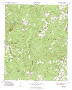
Verdery Topo Map South Carolina
To zoom in, hover over the map of Verdery
USGS Topo Quad 34082a3 - 1:24,000 scale
| Topo Map Name: | Verdery |
| USGS Topo Quad ID: | 34082a3 |
| Print Size: | ca. 21 1/4" wide x 27" high |
| Southeast Coordinates: | 34° N latitude / 82.25° W longitude |
| Map Center Coordinates: | 34.0625° N latitude / 82.3125° W longitude |
| U.S. State: | SC |
| Filename: | o34082a3.jpg |
| Download Map JPG Image: | Verdery topo map 1:24,000 scale |
| Map Type: | Topographic |
| Topo Series: | 7.5´ |
| Map Scale: | 1:24,000 |
| Source of Map Images: | United States Geological Survey (USGS) |
| Alternate Map Versions: |
Verdery SC 1948, updated 1974 Download PDF Buy paper map Verdery SC 1950 Download PDF Buy paper map Verdery SC 2011 Download PDF Buy paper map Verdery SC 2014 Download PDF Buy paper map |
| FStopo: | US Forest Service topo Verdery is available: Download FStopo PDF Download FStopo TIF |
1:24,000 Topo Quads surrounding Verdery
> Back to 34082a1 at 1:100,000 scale
> Back to 34082a1 at 1:250,000 scale
> Back to U.S. Topo Maps home
Verdery topo map: Gazetteer
Verdery: Bends
Big Bottom elevation 104m 341′Verdery: Bridges
Bradley Bridge elevation 103m 337′Verdery: Dams
Four H Club Dam D-3040 elevation 155m 508′South Carolina Noname 01001 D-3039 Dam elevation 134m 439′
South Carolina Noname 24006 D-1262 Dam elevation 156m 511′
Verdery: Forests
Sumter National Forest elevation 165m 541′Verdery: Parks
Cedar Springs Historic District elevation 154m 505′Long Cane Scenic Area elevation 135m 442′
Verdery: Populated Places
Bradley Corner elevation 144m 472′Cedar Springs elevation 154m 505′
Clatworthy Crossroads elevation 172m 564′
Verdery: Reservoirs
A M Tucks Pond elevation 156m 511′Four H Club Lake elevation 155m 508′
Parson Mountain Lake elevation 134m 439′
Parsons Mountain Lake elevation 134m 439′
Verdery: Streams
Big Curltail Creek elevation 113m 370′Candy Branch elevation 110m 360′
Chapel Branch elevation 107m 351′
Church Branch elevation 112m 367′
Cow Branch elevation 103m 337′
Edwards Branch elevation 125m 410′
Fell Branch elevation 130m 426′
Flat Branch elevation 104m 341′
George Devlin Branch elevation 119m 390′
Horeb Branch elevation 119m 390′
Little Muckaway Creek elevation 119m 390′
Little Persimmon Branch elevation 119m 390′
McGill Branch elevation 118m 387′
Mountain Creek elevation 111m 364′
Persimmon Branch elevation 115m 377′
Puckett Branch elevation 126m 413′
Reedy Branch elevation 103m 337′
Richie Branch elevation 118m 387′
Rocky Branch elevation 106m 347′
South Fork elevation 115m 377′
Stillhouse Branch elevation 113m 370′
Wharton Branch elevation 130m 426′
Verdery: Summits
Laurel Hill elevation 134m 439′Parsons Mountain elevation 249m 816′
Verdery digital topo map on disk
Buy this Verdery topo map showing relief, roads, GPS coordinates and other geographical features, as a high-resolution digital map file on DVD:
South Carolina, Western North Carolina & Northeastern Georgia
Buy digital topo maps: South Carolina, Western North Carolina & Northeastern Georgia


