Lowndesville Topo Map South Carolina
To zoom in, hover over the map of Lowndesville
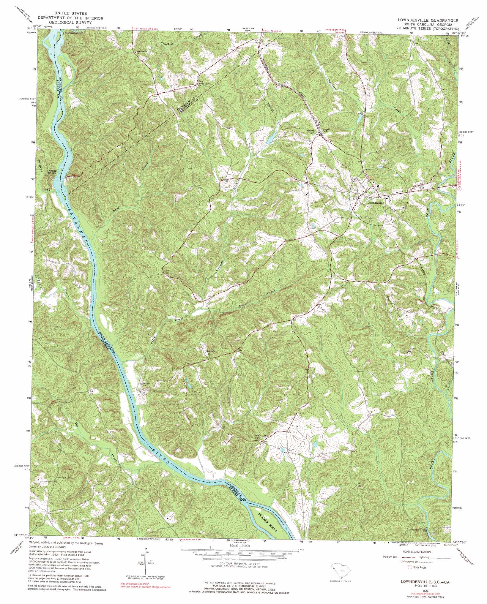
USGS Topo Quad 34082b6 - 1:24,000 scale
| Topo Map Name: | Lowndesville |
| USGS Topo Quad ID: | 34082b6 |
| Print Size: | ca. 21 1/4" wide x 27" high |
| Southeast Coordinates: | 34.125° N latitude / 82.625° W longitude |
| Map Center Coordinates: | 34.1875° N latitude / 82.6875° W longitude |
| U.S. States: | SC, GA |
| Filename: | o34082b6.jpg |
| Download Map JPG Image: | Lowndesville topo map 1:24,000 scale |
| Map Type: | Topographic |
| Topo Series: | 7.5´ |
| Map Scale: | 1:24,000 |
| Source of Map Images: | United States Geological Survey (USGS) |
| Alternate Map Versions: |
Lowndesville SC 1964, updated 1965 Download PDF Buy paper map Lowndesville SC 1964, updated 1980 Download PDF Buy paper map Lowndesville SC 1964, updated 1989 Download PDF Buy paper map Lowndesville SC 2011 Download PDF Buy paper map Lowndesville SC 2014 Download PDF Buy paper map |
1:24,000 Topo Quads surrounding Lowndesville
Reed Creek |
Hartwell Ne |
Anderson South |
Saylors Crossroads |
Honea Path |
Hartwell |
Hartwell Dam |
Iva |
Antreville |
Due West |
Dewy Rose |
Rock Branch |
Lowndesville |
Latimer |
Abbeville West |
Elberton West |
Elberton East |
Heardmont |
Calhoun Falls |
Calhoun Creek |
Vesta |
Jacksons Crossroads |
Broad |
Chennault |
Willington |
> Back to 34082a1 at 1:100,000 scale
> Back to 34082a1 at 1:250,000 scale
> Back to U.S. Topo Maps home
Lowndesville topo map: Gazetteer
Lowndesville: Bars
Gregg Shoals elevation 128m 419′Lowndesville: Crossings
Bowman Ferry (historical) elevation 124m 406′Bowman Ferry (historical) elevation 124m 406′
Crafts Ferry (historical) elevation 132m 433′
Crafts Ferry (historical) elevation 132m 433′
Harpers Ferry (historical) elevation 123m 403′
Harpers Ferry (historical) elevation 123m 403′
Lowndesville: Dams
B B Dunn Pond Dam D-3027 elevation 163m 534′Paradise Valley Lake Dam D-3029 elevation 155m 508′
Lowndesville: Islands
McCalla Island elevation 127m 416′Lowndesville: Parks
Richard B Russell State Park elevation 172m 564′Lowndesville: Populated Places
Diamond Hill Spring (historical) elevation 156m 511′Duke (historical) elevation 189m 620′
Edinburg (historical) elevation 149m 488′
Lowndesville elevation 185m 606′
Rocky River (historical) elevation 140m 459′
Lowndesville: Post Offices
Lowndesville Post Office elevation 177m 580′Lowndesville: Springs
Diamond Spring elevation 146m 479′Lowndesville: Streams
Allen Creek elevation 124m 406′Bond Creek elevation 126m 413′
Bowman Branch elevation 136m 446′
Charlies Creek elevation 137m 449′
Coldwater Creek elevation 125m 410′
Deal Creek elevation 134m 439′
Little Generostee Creek elevation 133m 436′
Long Branch elevation 140m 459′
Pickens Creek elevation 128m 419′
Van Creek elevation 123m 403′
Lowndesville digital topo map on disk
Buy this Lowndesville topo map showing relief, roads, GPS coordinates and other geographical features, as a high-resolution digital map file on DVD:
South Carolina, Western North Carolina & Northeastern Georgia
Buy digital topo maps: South Carolina, Western North Carolina & Northeastern Georgia