Belton East Topo Map South Carolina
To zoom in, hover over the map of Belton East
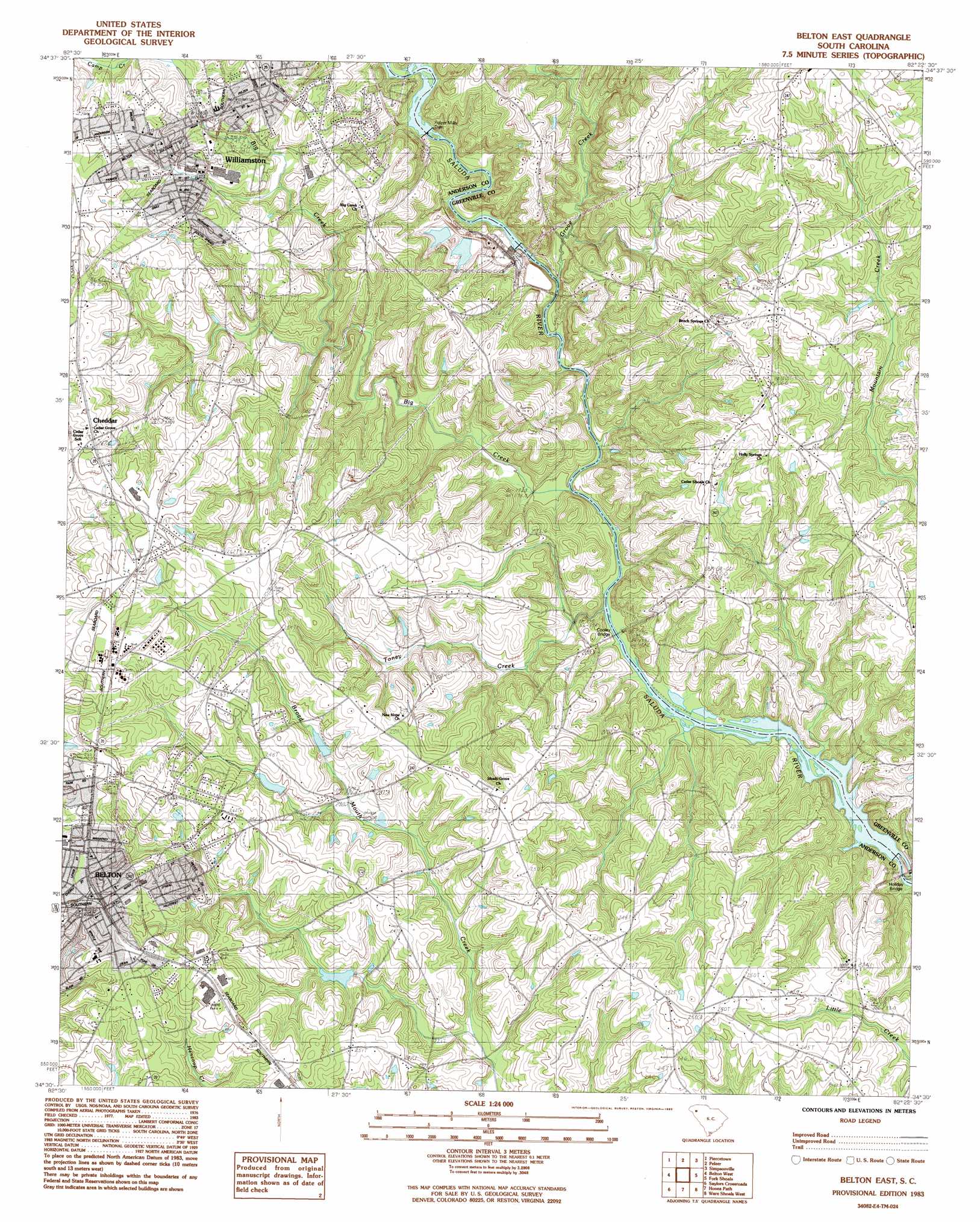
USGS Topo Quad 34082e4 - 1:24,000 scale
| Topo Map Name: | Belton East |
| USGS Topo Quad ID: | 34082e4 |
| Print Size: | ca. 21 1/4" wide x 27" high |
| Southeast Coordinates: | 34.5° N latitude / 82.375° W longitude |
| Map Center Coordinates: | 34.5625° N latitude / 82.4375° W longitude |
| U.S. State: | SC |
| Filename: | o34082e4.jpg |
| Download Map JPG Image: | Belton East topo map 1:24,000 scale |
| Map Type: | Topographic |
| Topo Series: | 7.5´ |
| Map Scale: | 1:24,000 |
| Source of Map Images: | United States Geological Survey (USGS) |
| Alternate Map Versions: |
Belton East SC 1983, updated 1983 Download PDF Buy paper map Belton East SC 2011 Download PDF Buy paper map Belton East SC 2014 Download PDF Buy paper map |
1:24,000 Topo Quads surrounding Belton East
Liberty |
Easley |
Greenville |
Mauldin |
Pelham |
Five Forks |
Piercetown |
Pelzer |
Simpsonville |
Fountain Inn |
Anderson North |
Belton West |
Belton East |
Fork Shoals |
Hickory Tavern |
Anderson South |
Saylors Crossroads |
Honea Path |
Ware Shoals West |
Ware Shoals East |
Iva |
Antreville |
Due West |
Shoals Junction |
Cokesbury |
> Back to 34082e1 at 1:100,000 scale
> Back to 34082a1 at 1:250,000 scale
> Back to U.S. Topo Maps home
Belton East topo map: Gazetteer
Belton East: Airports
Moores Field elevation 264m 866′Belton East: Bridges
Cooley Bridge elevation 189m 620′Belton East: Crossings
Clarks Ferry (historical) elevation 188m 616′Hollands Ford elevation 195m 639′
Pierces Ford elevation 189m 620′
Belton East: Dams
Assembly Acres Camp Lake Dam D-2881 elevation 197m 646′August Pond Dam D-2861 elevation 248m 813′
G Stevens Pond Dam D-3147 elevation 241m 790′
Holidays Bridge Dam elevation 242m 793′
Pelzer Mills Dam elevation 207m 679′
Pelzer Mills Dam D-2848 elevation 203m 666′
Rice Mills Pond Dam D-3145 elevation 237m 777′
South Carolina Noname 04010 D-3146 Dam elevation 240m 787′
South Carolina Noname 04012 D-3143 Dam elevation 234m 767′
South Carolina Noname 04013 D-3142 Dam elevation 259m 849′
South Carolina Noname 04028 D-3144 Dam elevation 265m 869′
Belton East: Populated Places
Belton elevation 275m 902′Cheddar elevation 268m 879′
Toney Creek elevation 209m 685′
Williamston elevation 248m 813′
Belton East: Post Offices
Belton Post Office elevation 277m 908′Tony Creek Post Office (historical) elevation 198m 649′
Belton East: Reservoirs
Assembly Acres Camp Lake elevation 197m 646′August Pond elevation 248m 813′
Broadmouth Creek Watershed Eight Lake elevation 234m 767′
Broadmouth Creek Watershed Nine Lake elevation 259m 849′
Broadmouth Creek Watershed Two Lake elevation 240m 787′
Cox Ponds elevation 245m 803′
Belton East: Streams
Big Creek elevation 189m 620′East Prong Broadmouth Creek elevation 232m 761′
Grove Creek elevation 193m 633′
Toney Creek elevation 191m 626′
West Prong Broadmouth Creek elevation 232m 761′
Belton East digital topo map on disk
Buy this Belton East topo map showing relief, roads, GPS coordinates and other geographical features, as a high-resolution digital map file on DVD:
South Carolina, Western North Carolina & Northeastern Georgia
Buy digital topo maps: South Carolina, Western North Carolina & Northeastern Georgia