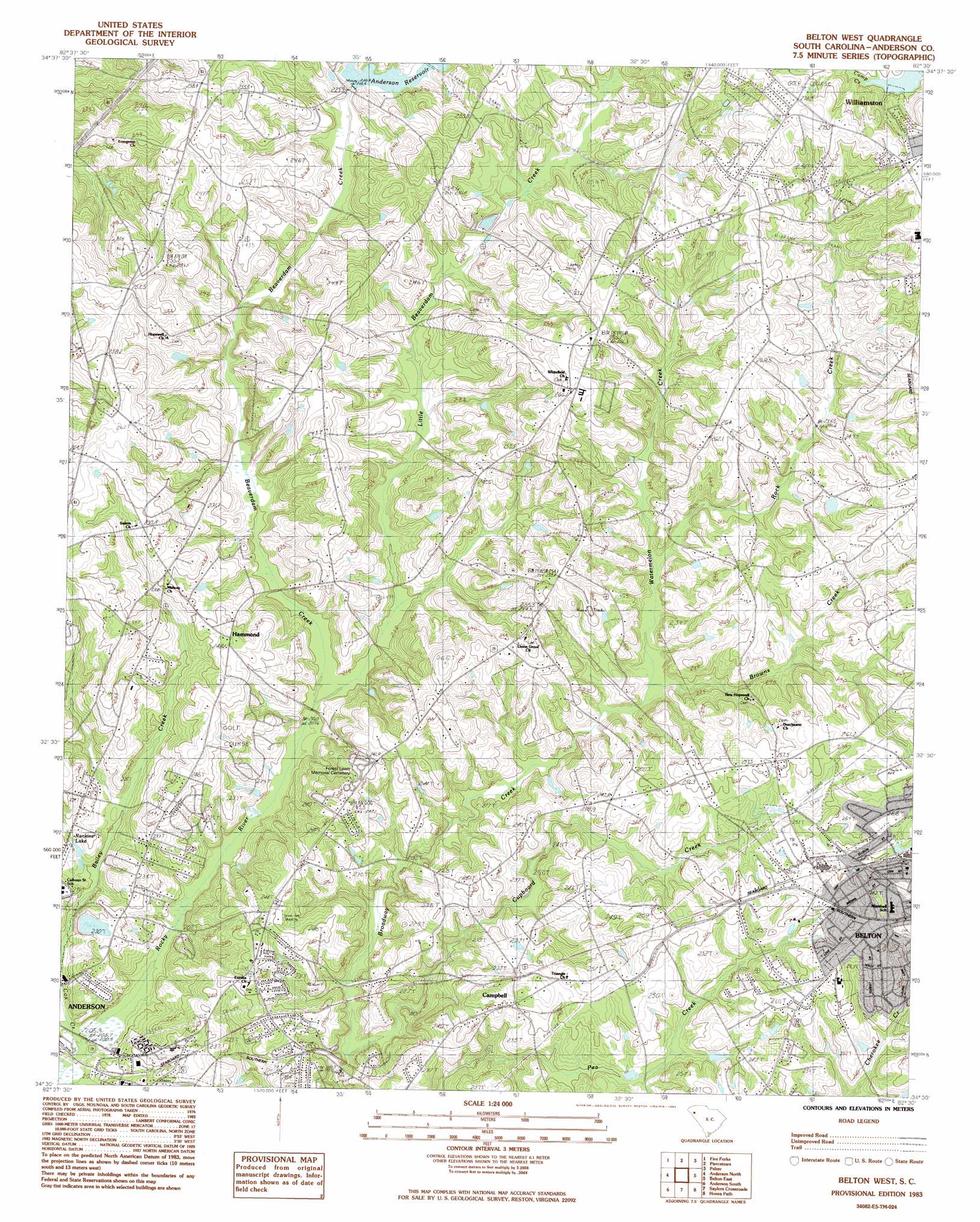
Belton West Topo Map South Carolina
To zoom in, hover over the map of Belton West
USGS Topo Quad 34082e5 - 1:24,000 scale
| Topo Map Name: | Belton West |
| USGS Topo Quad ID: | 34082e5 |
| Print Size: | ca. 21 1/4" wide x 27" high |
| Southeast Coordinates: | 34.5° N latitude / 82.5° W longitude |
| Map Center Coordinates: | 34.5625° N latitude / 82.5625° W longitude |
| U.S. State: | SC |
| Filename: | o34082e5.jpg |
| Download Map JPG Image: | Belton West topo map 1:24,000 scale |
| Map Type: | Topographic |
| Topo Series: | 7.5´ |
| Map Scale: | 1:24,000 |
| Source of Map Images: | United States Geological Survey (USGS) |
| Alternate Map Versions: |
Belton West SC 1983, updated 1983 Download PDF Buy paper map Belton West SC 1983, updated 1983 Download PDF Buy paper map Belton West SC 2011 Download PDF Buy paper map Belton West SC 2014 Download PDF Buy paper map |
1:24,000 Topo Quads surrounding Belton West
Six Mile |
Liberty |
Easley |
Greenville |
Mauldin |
Clemson |
Five Forks |
Piercetown |
Pelzer |
Simpsonville |
La France |
Anderson North |
Belton West |
Belton East |
Fork Shoals |
Hartwell Ne |
Anderson South |
Saylors Crossroads |
Honea Path |
Ware Shoals West |
Hartwell Dam |
Iva |
Antreville |
Due West |
Shoals Junction |
> Back to 34082e1 at 1:100,000 scale
> Back to 34082a1 at 1:250,000 scale
> Back to U.S. Topo Maps home
Belton West topo map: Gazetteer
Belton West: Dams
Bailey Creek Reservoir Dam D-3125 elevation 219m 718′Haven of Rest Pond Dam D-3133 elevation 239m 784′
Lollis Pond Dam D-3140 elevation 253m 830′
Parkwood Lake Dam D-3115 elevation 224m 734′
Belton West: Populated Places
Beaver Creek elevation 248m 813′Briarcliff elevation 227m 744′
Campbell elevation 244m 800′
Cedar Acres elevation 240m 787′
Cobbs Glen elevation 233m 764′
Country Acres elevation 248m 813′
Country Estates elevation 234m 767′
Country Place elevation 257m 843′
Creekwood Hills elevation 222m 728′
Devonshire elevation 262m 859′
Dobbins Estates elevation 236m 774′
Erskine Estates elevation 238m 780′
Fox Valley elevation 232m 761′
Hammond elevation 259m 849′
Hampton Acres elevation 255m 836′
Heather Heights elevation 235m 770′
Highland Acres elevation 233m 764′
Keystone Acres elevation 230m 754′
Long Meadows elevation 242m 793′
Marilyn Acres elevation 250m 820′
Pinecrest elevation 253m 830′
White Oaks elevation 256m 839′
Windward Trail elevation 256m 839′
Belton West: Post Offices
Aaron Post Office (historical) elevation 270m 885′Belton West: Reservoirs
Anderson Reservoir elevation 230m 754′Bailey Creek Reservoir elevation 219m 718′
Ivester Lake elevation 251m 823′
Morrisons Lake elevation 229m 751′
Belton West: Streams
Beaverdam Creek elevation 217m 711′Browns Creek elevation 225m 738′
Cox Creek elevation 208m 682′
Cupboard Creek elevation 215m 705′
Little Beaverdam Creek elevation 227m 744′
Rock Creek elevation 237m 777′
Watermelon Creek elevation 226m 741′
Belton West digital topo map on disk
Buy this Belton West topo map showing relief, roads, GPS coordinates and other geographical features, as a high-resolution digital map file on DVD:
South Carolina, Western North Carolina & Northeastern Georgia
Buy digital topo maps: South Carolina, Western North Carolina & Northeastern Georgia