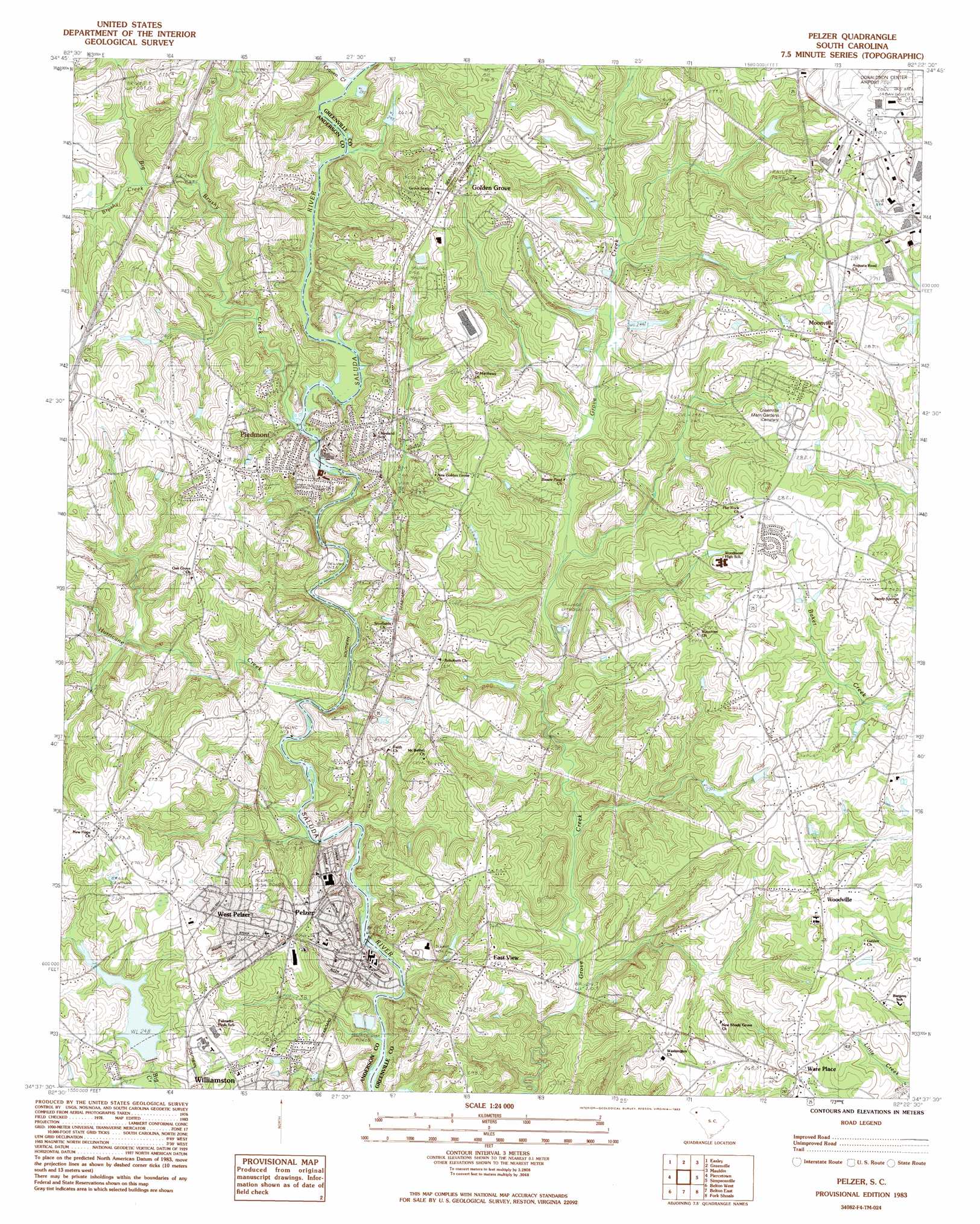
Pelzer Topo Map South Carolina
To zoom in, hover over the map of Pelzer
USGS Topo Quad 34082f4 - 1:24,000 scale
| Topo Map Name: | Pelzer |
| USGS Topo Quad ID: | 34082f4 |
| Print Size: | ca. 21 1/4" wide x 27" high |
| Southeast Coordinates: | 34.625° N latitude / 82.375° W longitude |
| Map Center Coordinates: | 34.6875° N latitude / 82.4375° W longitude |
| U.S. State: | SC |
| Filename: | o34082f4.jpg |
| Download Map JPG Image: | Pelzer topo map 1:24,000 scale |
| Map Type: | Topographic |
| Topo Series: | 7.5´ |
| Map Scale: | 1:24,000 |
| Source of Map Images: | United States Geological Survey (USGS) |
| Alternate Map Versions: |
Pelzer SC 1983, updated 1983 Download PDF Buy paper map Pelzer SC 1983, updated 1983 Download PDF Buy paper map Pelzer SC 2011 Download PDF Buy paper map Pelzer SC 2014 Download PDF Buy paper map |
1:24,000 Topo Quads surrounding Pelzer
Pickens |
Dacusville |
Paris Mountain |
Taylors |
Greer |
Liberty |
Easley |
Greenville |
Mauldin |
Pelham |
Five Forks |
Piercetown |
Pelzer |
Simpsonville |
Fountain Inn |
Anderson North |
Belton West |
Belton East |
Fork Shoals |
Hickory Tavern |
Anderson South |
Saylors Crossroads |
Honea Path |
Ware Shoals West |
Ware Shoals East |
> Back to 34082e1 at 1:100,000 scale
> Back to 34082a1 at 1:250,000 scale
> Back to U.S. Topo Maps home
Pelzer topo map: Gazetteer
Pelzer: Crossings
Martin Ford elevation 227m 744′Wilsons Ferry (historical) elevation 222m 728′
Pelzer: Dams
Browns Pond Dam D-2858 elevation 274m 898′Davis Pond Dam D-2846 elevation 255m 836′
Freemans Lake Dam D-2843 elevation 247m 810′
Garrison Pond Dam D-2844 elevation 248m 813′
Garrison Pond Number One Dam D-2845 elevation 259m 849′
Lake Eljama Dam D-2860 elevation 245m 803′
Piedmont Dam elevation 245m 803′
Prince Lake Dam D-2859 elevation 247m 810′
South Carolina Noname 04008 Dam elevation 251m 823′
South Carolina Noname 04009 Dam elevation 247m 810′
Stewarts Pond Dam D-2847 elevation 242m 793′
Pelzer: Populated Places
Belle Terre Acres elevation 250m 820′Canterbury elevation 278m 912′
Chesterfield Estates elevation 263m 862′
East View elevation 240m 787′
Golden Grove elevation 267m 875′
Moonville elevation 282m 925′
Pelzer elevation 229m 751′
Piedmont elevation 240m 787′
Ware Place elevation 268m 879′
West Pelzer elevation 259m 849′
Woodville elevation 271m 889′
Pelzer: Rapids
Allen Shoals elevation 228m 748′Pelzer: Reservoirs
Big Creek Watershed One Reservoir elevation 251m 823′Big Creek Watershed Two Reservoir elevation 247m 810′
Browns Pond elevation 274m 898′
Davis Pond elevation 255m 836′
Freemans Lake elevation 247m 810′
Lake Eljama elevation 245m 803′
Piedmont Reservoir elevation 245m 803′
Prince Lake elevation 247m 810′
Stewarts Pond elevation 242m 793′
Pelzer: Streams
Big Brushy Creek elevation 234m 767′Camp Creek elevation 244m 800′
Craven Creek elevation 240m 787′
Hurricane Creek elevation 230m 754′
Little Brushy Creek elevation 249m 816′
Little Grove Creek elevation 248m 813′
Mill Creek elevation 248m 813′
Pelzer digital topo map on disk
Buy this Pelzer topo map showing relief, roads, GPS coordinates and other geographical features, as a high-resolution digital map file on DVD:
South Carolina, Western North Carolina & Northeastern Georgia
Buy digital topo maps: South Carolina, Western North Carolina & Northeastern Georgia