Greenville Topo Map South Carolina
To zoom in, hover over the map of Greenville
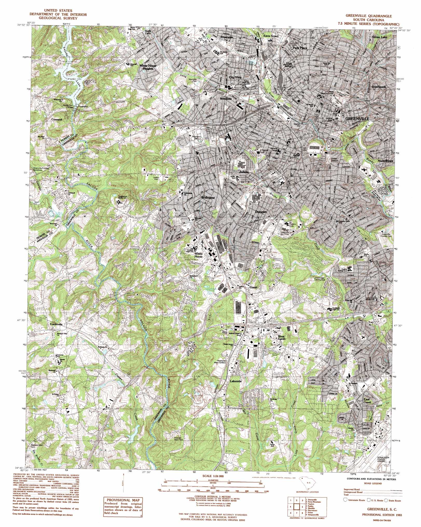
USGS Topo Quad 34082g4 - 1:24,000 scale
| Topo Map Name: | Greenville |
| USGS Topo Quad ID: | 34082g4 |
| Print Size: | ca. 21 1/4" wide x 27" high |
| Southeast Coordinates: | 34.75° N latitude / 82.375° W longitude |
| Map Center Coordinates: | 34.8125° N latitude / 82.4375° W longitude |
| U.S. State: | SC |
| Filename: | o34082g4.jpg |
| Download Map JPG Image: | Greenville topo map 1:24,000 scale |
| Map Type: | Topographic |
| Topo Series: | 7.5´ |
| Map Scale: | 1:24,000 |
| Source of Map Images: | United States Geological Survey (USGS) |
| Alternate Map Versions: |
Greenville SC 1957, updated 1958 Download PDF Buy paper map Greenville SC 1957, updated 1977 Download PDF Buy paper map Greenville SC 1983, updated 1983 Download PDF Buy paper map Greenville SC 1983, updated 1983 Download PDF Buy paper map Greenville SC 2011 Download PDF Buy paper map Greenville SC 2014 Download PDF Buy paper map |
1:24,000 Topo Quads surrounding Greenville
Table Rock |
Cleveland |
Slater |
Tigerville |
Campobello |
Pickens |
Dacusville |
Paris Mountain |
Taylors |
Greer |
Liberty |
Easley |
Greenville |
Mauldin |
Pelham |
Five Forks |
Piercetown |
Pelzer |
Simpsonville |
Fountain Inn |
Anderson North |
Belton West |
Belton East |
Fork Shoals |
Hickory Tavern |
> Back to 34082e1 at 1:100,000 scale
> Back to 34082a1 at 1:250,000 scale
> Back to U.S. Topo Maps home
Greenville topo map: Gazetteer
Greenville: Airports
Donaldson Center Airport elevation 286m 938′Palmetto Heliport elevation 270m 885′
Greenville: Bridges
Dunham Bridge elevation 247m 810′Easley Bridge elevation 245m 803′
Saluda Dam Bridge elevation 255m 836′
Greenville: Crossings
Interchange 1 elevation 304m 997′Interchange 2 elevation 276m 905′
Interchange 39 elevation 291m 954′
Interchange 40 elevation 275m 902′
Interchange 42 elevation 272m 892′
Interchange 42 elevation 273m 895′
Interchange 43 elevation 308m 1010′
Interchange 44 elevation 307m 1007′
Interchange 45 elevation 253m 830′
Greenville: Dams
Saluda Dam elevation 258m 846′South Carolina Noname 04003 D-3141 Dam elevation 254m 833′
Greenville: Mines
Lakeside Quarry elevation 251m 823′Greenville: Parks
Arthur Black Park elevation 289m 948′Augusta Road Park elevation 303m 994′
Catlin Park elevation 283m 928′
Cleveland Park elevation 264m 866′
Colonel Elias Earle Historic District elevation 310m 1017′
Dunean Park elevation 298m 977′
Green Forest Park elevation 272m 892′
Hampton-Pinckney Historic District elevation 307m 1007′
Heritage Green elevation 306m 1003′
Lakeside Park elevation 292m 958′
McPherson Park elevation 284m 931′
Meadowbrook Park elevation 291m 954′
Pettigru Street Historic District elevation 303m 994′
Piazza Bergamo elevation 307m 1007′
Poe Mill Park elevation 300m 984′
Reedy River Falls Park elevation 278m 912′
Rockwood Park elevation 280m 918′
Sirrine Stadium elevation 272m 892′
Watts Park elevation 287m 941′
Westside Park elevation 303m 994′
Woodside Cotton Mill Village Historic District elevation 296m 971′
Greenville: Populated Places
Alta Vista elevation 290m 951′Athelone Heights elevation 292m 958′
Belaire Estates elevation 283m 928′
Belle Meade elevation 274m 898′
Biltmore elevation 284m 931′
Boyce Lawn elevation 303m 994′
Brandon elevation 305m 1000′
Brookforest Estates elevation 272m 892′
Carolina Heights elevation 275m 902′
Carver Park elevation 307m 1007′
Chanticleer elevation 284m 931′
Chestnut Hills elevation 291m 954′
City View elevation 302m 990′
Cleveland Forest elevation 268m 879′
Club Forest elevation 280m 918′
Crosswell elevation 290m 951′
Cutler Ridge elevation 290m 951′
Dreher Colony elevation 271m 889′
Dunean elevation 304m 997′
East Gantt elevation 286m 938′
Elizabeth Heights elevation 279m 915′
Enchanted Forest elevation 307m 1007′
Fairfield Acres elevation 290m 951′
Farmington Acres elevation 310m 1017′
Gantt elevation 299m 980′
Glendale elevation 288m 944′
Greenville elevation 307m 1007′
Holly Springs elevation 285m 935′
Hughes Heights elevation 316m 1036′
Judson elevation 298m 977′
Knollwood elevation 279m 915′
Lakeside elevation 290m 951′
Lockwood Heights elevation 318m 1043′
Mansfield Park elevation 307m 1007′
Monaghan elevation 298m 977′
Mountain View Homes elevation 305m 1000′
North Hills elevation 283m 928′
Oak Crest elevation 297m 974′
Overbrook elevation 296m 971′
Oxford Acres elevation 281m 921′
Palmetto Terrace elevation 273m 895′
Park Lane Terrace elevation 284m 931′
Park Place elevation 311m 1020′
Parker elevation 309m 1013′
Pecan Terrace elevation 273m 895′
Pine Hill Village elevation 289m 948′
Plainview Heights elevation 297m 974′
Pleasant Valley elevation 273m 895′
Poinsett elevation 306m 1003′
Powderville elevation 296m 971′
Quail Haven elevation 261m 856′
Riley Estates elevation 298m 977′
Riverside elevation 308m 1010′
Rockvale elevation 285m 935′
Roosevelt Heights elevation 279m 915′
Roseman Heights elevation 287m 941′
Royal Oaks elevation 276m 905′
Sampson elevation 305m 1000′
Smith Heights elevation 288m 944′
South Forest Estates elevation 276m 905′
Spring Brook Terrace elevation 289m 948′
Staunton Heights elevation 295m 967′
Stone Lake elevation 288m 944′
Sunny Acres elevation 310m 1017′
Supreme Forest elevation 295m 967′
Tanglewood elevation 300m 984′
The Highlands elevation 271m 889′
Traxler Park elevation 281m 921′
University Ridge Homes elevation 264m 866′
View Point Place elevation 307m 1007′
Welcome elevation 300m 984′
Welcome Acres elevation 298m 977′
West Gantt elevation 296m 971′
West Greenville elevation 299m 980′
Westcliffe elevation 309m 1013′
Westville elevation 315m 1033′
White Horse elevation 297m 974′
White Horse Heights elevation 315m 1033′
White Oak Hills elevation 323m 1059′
Woodbriar elevation 300m 984′
Woodfield Heights elevation 271m 889′
Woodfields elevation 269m 882′
Woodside elevation 293m 961′
Greenville: Post Offices
Greenville Post Office elevation 305m 1000′Greenville: Reservoirs
Huffs Lake elevation 304m 997′Lakeside Lake elevation 251m 823′
Saluda Lake elevation 258m 846′
Woodson Pond elevation 254m 833′
Greenville: Ridges
University Ridge elevation 304m 997′Greenville: Streams
Georges Creek elevation 241m 790′Long Branch elevation 284m 931′
Richland Creek elevation 258m 846′
Greenville digital topo map on disk
Buy this Greenville topo map showing relief, roads, GPS coordinates and other geographical features, as a high-resolution digital map file on DVD:
South Carolina, Western North Carolina & Northeastern Georgia
Buy digital topo maps: South Carolina, Western North Carolina & Northeastern Georgia